
Powys is a county and preserved county in Wales. It is named after the Kingdom of Powys which was a Welsh successor state, petty kingdom and principality that emerged during the Middle Ages following the end of Roman rule in Britain.
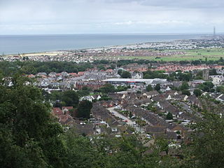
Abergele is a market town and community, situated on the north coast of Wales between the holiday resorts of Colwyn Bay and Rhyl, in Conwy County Borough and in the historic county of Denbighshire. Its northern suburb of Pensarn lies on the Irish Sea coast. Abergele and Pensarn railway station serves both resorts. Abergele is often overlooked due to the popularity of towns in nearby Rhyl, Prestatyn, Colwyn Bay, Llandudno and Conwy. Only 46.5% of the population was born in Wales as of the 2011 census.

Moel Hebog is a mountain in Snowdonia, north Wales which dominates the view west from the village of Beddgelert. It gives name to a whole range of peaks in the north-western corner of Snowdonia, which include the Nantlle Ridge and Mynydd Mawr.

Dan yr Ogof, at the National Showcaves Centre for Wales, is a 17-kilometre (11 mi) long cave system in south Wales, about 5 miles (8 km) north of Ystradgynlais and 15 miles (24 km) southwest of Brecon, in the Brecon Beacons National Park. It is the main feature of a show cave complex, which is claimed to be the largest in the UK and is a tourist attraction in Wales. The first section of the cave system is open to the public, but the extensive cave system beyond is scheduled as a national nature reserve and is open only to bona fide cavers.

The Minera Limeworks were extensive lime quarries and kilns at Minera in Wrexham, Wales. It was located at grid reference SJ253520, near the villages of Gwynfryn, Minera, and Coedpoeth and was locally referred to as The Calch.

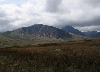
Pen Llithrig y Wrach is a mountain peak in Snowdonia, Wales. It is one of the four Marilyns that make up the Carneddau range. To the east is Creigiau Gleision, another Marilyn, while to the west is Pen yr Helgi Du and Carnedd Llewelyn. Craig Eigiau and Llyn Eigiau can be seen to the north, while Gallt yr Ogof, Glyder Fach and Tryfan can be viewed to the south.
The Swansea Valley is one of the South Wales Valleys. It is the valley from the Brecon Beacons National Park to the sea at Swansea of the River Tawe in Wales. Administration of the area is divided between the City and County of Swansea, Neath Port Talbot County Borough, and Powys. A distinction may be drawn between the Lower Swansea valley and the Upper Swansea valley; the former was more heavily industrialised during the 19th and 20th centuries.
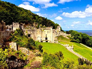
Gwrych Castle is a Grade I listed 19th-century country house near Abergele in Conwy County Borough, Wales. The castle and 236 acre estate are owned by a charity, and a portion of the land is leased to Natural Resources Wales for a 999-year term.

Llanddulas is a village in Conwy county borough, Wales, midway between Old Colwyn and Abergele and next to the North Wales Expressway in the community of Llanddulas and Rhyd-y-Foel. The village lies beneath the limestone hill of Cefn-yr-Ogof (670 ft). This hill has large caves, and quarrying of limestone was formerly the main industry of the village, with crushed stone being exported from the 200 m long jetty.

Cefn yr Ystrad is a mountain in the Brecon Beacons National Park in Wales. It is an outlier of the Central Beacons group.
Gallt yr Ogof is a mountain in Snowdonia, North Wales. It is a subsidiary top of Glyder Fawr, and is the most easterly point in the Glyderau mountain range, not including the hill Cefn y Capel. Gallt yr Ogof is 763 metres high.

Long Mountain is a hill straddling the boundary between Powys (Wales) and Shropshire (England) to the east of Welshpool though the summit at 408 metres at Beacon Ring is within Wales. Long Mountain is a Marilyn, having a prominence of 305 metres.
Esclusham Mountain is an area in Wrexham County Borough, Wales, United Kingdom, and is part of the Ruabon Moors. It rises to a height of 460 m, with the nearby spur of Cyrn-y-Brain, to the west, reaching 473 m. It lies mostly within the community of Esclusham. A smaller spur to the north, known as Minera Mountain, is within the neighbouring community of Minera.

Llanddulas Limestone and Gwrych Castle Wood is a Site of Special Scientific Interest in the preserved county of Clwyd, north Wales. The designated area lies in the communities of Betws yn Rhos, Llanddulas and Rhyd-y-foel and Llysfaen. The hills of Cefn-yr-Ogof and Craig y Forwyn feature. Gwrych Castle Wood is part of Gwrych Castle, a privately owned estate.

Tawe-Uchaf is a community in Powys, Wales. Situated north-east of Ystradgynlais in the upper valley of the River Tawe, it includes the villages of Caehopkin, Coelbren, Glyntawe, Pen-y-cae, Penwyllt and Ynyswen. It had a population in 2001 of 1,516, increasing at the 2011 Census to 1,562.
Llanddulas and Rhyd-y-foel is a community in Conwy County Borough, in Wales. It is located on the coast of Liverpool Bay, at the mouth of the Afon Dulas, 2.7 miles (4.3 km) west of Abergele, 3.6 miles (5.8 km) east of Colwyn Bay and 9.0 miles (14.5 km) east of Conwy. As the name suggests, it consists of the villages of Llanddulas and Rhyd-y-foel. At the 2001 census the community had a population of 1,572, reducing slightly to 1,542 at the 2011 census.
This article describes the geology of the Brecon Beacons National Park in mid/south Wales. The area gained national park status in 1957 with the designated area of 1,344 km2 (519 sq mi) including mountain massifs to both the east and west of the Brecon Beacons proper. The geology of the national park consists of a thick succession of sedimentary rocks laid down from the late Ordovician through the Silurian and Devonian to the late Carboniferous period. The rock sequence most closely associated with the park is the Old Red Sandstone from which most of its mountains are formed. The older parts of the succession, in the northwest, were folded and faulted during the Caledonian orogeny. Further faulting and folding, particularly in the south of the park is associated with the Variscan orogeny.

