
Interstate 49 (I-49) is a north–south Interstate Highway with multiple segments. The original portion is entirely within Louisiana with an additional signed portion extending from I-220 in Shreveport to the Arkansas state line, three newer sections are in Arkansas, and one section in Missouri. Its southern terminus is in Lafayette, Louisiana, at I-10 while its northern terminus is in Kansas City, Missouri, at I-435 and I-470. Future plans include portions of the remaining roadway in Louisiana, Arkansas, and Texas, to link Kansas City, Missouri with New Orleans.

The Kansas Turnpike is a 236-mile (380 km) controlled-access toll road that lies entirely within the US state of Kansas. It runs in a general southwest–northeast direction from the Oklahoma border to Kansas City. It passes through several major Kansas cities, including Wichita, Topeka, and Lawrence. The turnpike is owned and maintained by the Kansas Turnpike Authority (KTA), which is headquartered in Wichita.

Fort Leavenworth is a United States Army installation located in Leavenworth County, Kansas, in the city of Leavenworth. Built in 1827, it is the second oldest active United States Army post west of Washington, D.C., and the oldest permanent settlement in Kansas. Fort Leavenworth has been historically known as the "Intellectual Center of the Army."
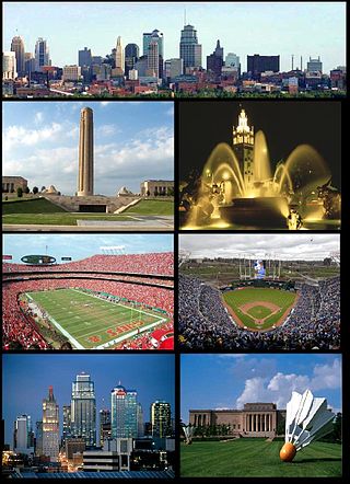
The Kansas City metropolitan area is a bi-state metropolitan area anchored by Kansas City, Missouri. Its 14 counties straddle the border between the U.S. states of Missouri and Kansas. With 8,472 square miles (21,940 km2) and a population of more than 2.2 million people, it is the second-largest metropolitan area centered in Missouri and is the largest metropolitan area in Kansas, though Wichita is the largest metropolitan area centered in Kansas. Alongside Kansas City, Missouri, these are the suburbs with populations above 100,000: Overland Park, Kansas; Kansas City, Kansas; Olathe, Kansas; Independence, Missouri; and Lee's Summit, Missouri.
Route 45 is a highway in northwest Missouri, US in Buchanan County and Platte County which is largely in the bottom land alongside the Missouri River.
Route 152 is a state highway in the northern Kansas City metropolitan area. It begins at Interstate 435 south of the Kansas City International Airport and ends at Route 291 in Liberty. The route is a limited access highway between its two junctions with I-435. It crosses I-29 five miles (8.0 km) south of the airport in Platte County and US 169 in Clay County.

Interstate 635 (I-635) is a connector highway between I-35 in Overland Park, Kansas, and I-29 in Kansas City, Missouri, Not to be Confused with Interstate 635 in texas approximately 12 miles (19 km) long. It is mostly in the US state of Kansas, servicing the city of Kansas City, Kansas, but extends into Kansas City, Missouri, as well. The freeway's southern terminus is at a stack interchange with I-35. South of this, the mainline becomes an expressway carrying U.S. Route 69 (US 69).

Forgottonia, also spelled Forgotonia, is the name given to a 16-county region in Western Illinois in the late 1960s and early 1970s. This geographic region forms the distinctive western bulge of Illinois that is roughly equivalent to "The Tract", the Illinois portion of the Military Tract of 1812, along and west of the Fourth Principal Meridian. Since this wedge-shaped region lies between the Illinois and Mississippi rivers, it has historically been isolated from the eastern portion of Central Illinois.
Louisiana Highway 10 (LA 10) is a state highway located in southern Louisiana. It runs 255.51 miles (411.20 km) in an east–west direction from U.S. Highway 171 (US 171) south of Leesville to the Mississippi state line east of Bogalusa.

The Fairfax Bridge and Platte Purchase Bridge were a pair of twin truss bridges over the Missouri River that handled traffic on U.S. Route 69 (US 69), connecting Interstate 635 (I-635) in Riverside, Missouri with the Seventh Street Trafficway in Fairfax, Kansas. The southbound span was built by the Kansas City Bridge Company, and was 2,486.5 feet (757.9 m) long and had 13 spans on 15 piers. The northbound spans biggest span was 465.96 feet and it is 2552.19 feet long and had a deck width of 28.31 feet and vertical clearance of 15.02 feet.

The Platte Purchase Bridge was a continuous truss bridge over the Missouri River that handled northbound U.S. Route 69, connecting the Seventh Street Trafficway in Fairfax, Kansas with Interstate 635 (Kansas–Missouri) in Riverside, Missouri. Its biggest span was 465.96 feet and it is 2552.19 feet long and had a deck width of 28.31 feet and vertical clearance of 15.02 feet. The bridge was named for the Platte Purchase.

Interstate 70 (I-70) is a mainline route of the Interstate Highway System in the United States connecting Cove Fort, Utah, to Baltimore, Maryland. In the US state of Kansas, I-70 extends just over 424 miles (682 km) from the Colorado border near the town of Kanorado to the Missouri border in Kansas City. I-70 in Kansas contains the first segment in the country to start being paved and to be completed in the Interstate Highway System. The route passes through several of the state's principal cities in the process, including Kansas City, Topeka, and Salina. The route also passes through the cities of Lawrence, Junction City, and Abilene.

Six special routes of U.S. Route 169 exist, one each in Oklahoma, Kansas, Missouri, and Iowa, and two in Minnesota.
Interstate 49 (I-49) is an Interstate Highway in the US state of Missouri that was designated on December 12, 2012. It overlaps U.S. Route 71 (US 71) in the western part of the state, beginning at the Arkansas state line, and ending at I-435 and I-470 on the southeast side of Kansas City.
The US 69 Missouri River Bridge is a girder bridge carrying U.S. Route 69 (US 69) over the Missouri River. It connects Interstate 635 (I-635) in Riverside, Missouri with the 7th Street Trafficway and Fairfax District in Kansas City, Kansas. Construction began in the fall of 2014. The bridge opened to automobile traffic in October 2016 and was formally opened to all traffic on March 16, 2017. In addition to automobiles, the bridge also carries bicycle and pedestrian traffic. It replaced the now-demolished Fairfax and Platte Purchase bridges. The bridge was constructed by the Missouri Department of Transportation at cost of $79 million. Construction costs were split with the Kansas Department of Transportation.
K-92 is an approximately 44-mile-long (71 km) state highway in the U.S. state of Kansas. K-92's western terminus is at K-4 south of the community of Rock Creek, and the eastern terminus is a continuation as Missouri State Route 92 at the Missouri border by the City of Leavenworth. K-92 is co-designated as U.S. Route 59 (US-59) in Oskaloosa, K-16 from Oskaloosa to McLouth, and K-7 and US-73 in Leavenworth. The majority of the route passes through rural farmland and is almost entirely a two-lane roadway, except for the overlap with K-7 and US-73 and a portion of the US-59 overlap, which are four-lane.

The Champ Clark Bridge was a five-span truss bridge over the Mississippi River connecting Louisiana, Missouri with the state of Illinois via US 54. It opened in 1928. In 2019, the bridge was replaced by a new bridge of the same name.

The Kansas and Missouri Bridge was an iron truss bridge across the Missouri River at Fort Leavenworth. The bridge opened in 1872 and closed permanently in 1955.

The Terminal Bridge was a pontoon bridge and then a through-truss swing bridge at Leavenworth, Kansas. The pontoon bridge opened in 1889. The steel truss bridge opened on January 2, 1894, and was demolished in 1987.

