Related Research Articles

Remote sensing is the acquisition of information about an object or phenomenon without making physical contact with the object, in contrast to in situ or on-site observation. The term is applied especially to acquiring information about Earth and other planets. Remote sensing is used in numerous fields, including geophysics, geography, land surveying and most Earth science disciplines. It also has military, intelligence, commercial, economic, planning, and humanitarian applications, among others.

The Landsat program is the longest-running enterprise for acquisition of satellite imagery of Earth. It is a joint NASA / USGS program. On 23 July 1972, the Earth Resources Technology Satellite was launched. This was eventually renamed to Landsat 1 in 1975. The most recent, Landsat 9, was launched on 27 September 2021.
DigitalGlobe was an American commercial vendor of space imagery and geospatial content, and operator of civilian remote sensing spacecraft. The company went public on the New York Stock Exchange on 14 May 2009, selling 14.7 million shares at US$19.00 each to raise US$279 million in capital. On 5 October 2017, Maxar Technologies completed its acquisition of DigitalGlobe.

Within the atmospheric sciences, atmospheric physics is the application of physics to the study of the atmosphere. Atmospheric physicists attempt to model Earth's atmosphere and the atmospheres of the other planets using fluid flow equations, radiation budget, and energy transfer processes in the atmosphere. In order to model weather systems, atmospheric physicists employ elements of scattering theory, wave propagation models, cloud physics, statistical mechanics and spatial statistics which are highly mathematical and related to physics. It has close links to meteorology and climatology and also covers the design and construction of instruments for studying the atmosphere and the interpretation of the data they provide, including remote sensing instruments. At the dawn of the space age and the introduction of sounding rockets, aeronomy became a subdiscipline concerning the upper layers of the atmosphere, where dissociation and ionization are important.
The Gravity Recovery and Climate Experiment (GRACE) was a joint mission of NASA and the German Aerospace Center (DLR). Twin satellites took detailed measurements of Earth's gravity field anomalies from its launch in March 2002 to the end of its science mission in October 2017. The two satellites were sometimes called Tom and Jerry, a nod to the famous cartoon. The GRACE Follow-On (GRACE-FO) is a continuation of the mission on near-identical hardware, launched in May 2018. On March 19, 2024, NASA announced that the successor to GRACE-FO would be Gravity Recovery and Climate Experiment-Continuity (GRACE-C), to be launched in or after 2028.
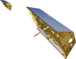
The Badr-B was the second spacecraft and the first Earth observation satellite launched into Sun-synchronous orbit on 10 December 2001 at 09:15 by SUPARCO — Pakistan's national space agency. Badr-B was a microsatellite, weighing approximately 70 kg, and contained a computerized system to conduct studies on gravity gradients. Badr-B was a research satellite to explore the upper atmosphere and the near space, carrying a large array of instruments for geophysical research.
Computational geophysics is the field of study that uses any type of numerical computations to generate and analyze models of complex geophysical systems. It can be considered an extension, or sub-field, of both computational physics and geophysics. In recent years, computational power, data availability, and modelling capabilities have all improved exponentially, making computational geophysics a more populated discipline. Due to the large computational size of many geophysical problems, high-performance computing can be required to handle analysis. Modeling applications of computational geophysics include atmospheric modelling, oceanic modelling, general circulation models, and geological modelling. In addition to modelling, some problems in remote sensing fall within the scope of computational geophysics such as tomography, inverse problems, and 3D reconstruction.

The Surface Water and Ocean Topography (SWOT) mission is a satellite altimeter jointly developed and operated by NASA and CNES, the French space agency, in partnership with the Canadian Space Agency (CSA) and UK Space Agency (UKSA). The objectives of the mission are to make the first global survey of the Earth's surface water, to observe the fine details of the ocean surface topography, and to measure how terrestrial surface water bodies change over time.

Soil Moisture Active Passive (SMAP) is a NASA environmental monitoring satellite that measures soil moisture across the planet. It is designed to collect a global 'snapshot' of soil moisture every 2 to 3 days. With this frequency, changes from specific storms can be measured while also assessing impacts across seasons of the year. SMAP was launched on 31 January 2015. It was one of the first Earth observation satellites developed by NASA in response to the National Research Council's Decadal Survey.
The University Nanosat Program is a satellite design and fabrication competition for universities. It is jointly administered by the Air Force Office of Scientific Research (AFOSR), the Air Force Research Laboratory (AFRL), the American Institute of Aeronautics and Astronautics (AIAA), the Space Development and Test Wing and the AFRL Space Vehicles Directorate's Spacecraft Technology division. NASA's Goddard Space Flight Center was involved from the program inception through Nanosat-3.

Goddard Space Flight Center (GSFC) is NASA's first, and oldest, space center. It is named after Robert H. Goddard, the father of modern rocketry. Throughout its history, the center has managed, developed, and operated many notable missions, including the Cosmic Background Explorer, the Hubble Space Telescope, the Tracking and Data Relay Satellite System (TDRSS), the Lunar Reconnaissance Orbiter, and the Solar Dynamics Observatory.
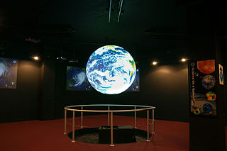
Science On a Sphere (SOS) is a spherical projection system created by the United States National Oceanic and Atmospheric Administration (NOAA). It displays high-resolution video on a suspended globe with the aim of better representing global phenomena. Animated images of atmospheric storms, climate change, and ocean temperature can be displayed on the sphere to display environmental processes. SOS systems are most frequently installed in science museums, universities, zoos, and research institutions.

Since its establishment in 1958, NASA has conducted research on a range of topics. Because of its unique structure, work happens at various field centers and different research areas are concentrated in those centers. Depending on the technology, hardware and expertise needed, research may be conducted across a range of centers.
The University of Georgia Computer Science Major is part of the UGA School of Computing, formerly known as the Computer Science Department. It operates under the joint administration of the Franklin College of Arts and Sciences and the University of Georgia College of Engineering. This restructuring occurred due to the rapid growth in the computer science major at the University of Georgia. While the original Computer Science department was established in 1984, the School of Computing was established on July 1, 2022.
The University of Georgia Small Satellite Research Laboratory (SSRL) is a research laboratory which builds CubeSats for Earth observation.

Claire Lucille Parkinson is an American Earth scientist and climatologist at NASA's Goddard Space Flight Center.
The history of space in Africa is the history of space activity by or sent from Africa.
Nadine Therese Laporte is a researcher and academic in the fields of forestry and remote sensing.
References
- 1 2 3 "History of the UGA Center Geospatial Research". Archived from the original on 2016-09-20. Retrieved 2016-09-17.
- 1 2 "Faculty of the UGA Center Geospatial Research". Archived from the original on 2016-09-20. Retrieved 2016-09-17.
- ↑ "Satellite Team Students attend Small Satellite Conference and have Program Management Review with the Air Force". Archived from the original on 2016-09-20. Retrieved 2016-09-17.
- ↑ "Millions projected to be at risk from sea-level rise in the continental United States". Nature. Retrieved 15 February 2016.
- ↑ "NASA Selects Proposals for Student Flight Research Opportunities". NASA. Retrieved 5 May 2016.
- ↑ "UGA team selected by NASA, Air Force to build and launch two cube satellites". UGA. Retrieved 8 May 2016.
- ↑ "NASA DEVELOP at UGA". Archived from the original on 2016-09-20. Retrieved 2016-09-17.
- ↑ "Identifying Key Urban Areas to Reduce Stormwater Runoff and Maximize Conservation Efforts in Metropolitan Atlanta". NASA. Retrieved 17 September 2016.
- ↑ "Using Satellite Observations for Conservation" (PDF). NASA. Retrieved 17 September 2016.
- ↑ "MOCI and SfM". Archived from the original on 2016-09-20. Retrieved 2016-09-17.
- ↑ MOCI and the UGA SSRL