Center of the World, Ohio

Last updated

Center of the World, Ohio
Center of the World, Ohio (42739979325).jpg
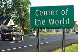
Sign at entrance of community
USA Ohio relief location map.svg
Red pog.svg
Center of the World, Ohio
Location in Ohio
Coordinates: 41°13′42″N80°54′35″W / 41.22833°N 80.90972°W / 41.22833; -80.90972
Country United States
State Ohio
County Trumbull
Time zone UTC-5 (Eastern (EST))
  Summer (DST) UTC-4 (EDT)

Center of the World is an unincorporated community in far eastern Braceville Township, Trumbull County, Ohio, United States. [1] [2] It consists of several houses and a few retail establishments centered at the crossroads where State Routes 82 and 5 diverge.

The community was founded by Randall Wilmot, an eccentric investor who had plans to make his new community a major economic center in northeast Ohio. When the railroads used the nearby city of Warren as the regional hub, Center of the World fell into decline both in terms of population and industry. [3]

Center of the World is part of the YoungstownWarrenBoardman, Ohio-Pennsylvania Metropolitan Statistical Area.

Related Research Articles

<span class="mw-page-title-main">Boardman Township, Ohio</span> Township in Mahoning County, Ohio, United States

Boardman Township is one of the fourteen townships of Mahoning County, Ohio, United States. The population was 40,213 at the 2020 census. A suburb directly south of Youngstown, it is the second largest municipality in the Youngstown–Warren metropolitan area and is a major retail hub for the region.

<span class="mw-page-title-main">Mason, Ohio</span> City in Ohio, United States

Mason is a city in southwestern Warren County, Ohio, United States, approximately 22 miles (35 km) north of downtown Cincinnati. As of the 2020 census, Mason's population was 34,792. It is home to Kings Island amusement park and one of the largest tennis stadiums in the world, the Lindner Family Tennis Center, home of the Western & Southern Open, one of the world's top tennis tournaments for both men and women.

<span class="mw-page-title-main">Fort Ancient (Lebanon, Ohio)</span> United States historic place

<span class="mw-page-title-main">Hillcrest, Ohio</span>

Hillcrest is an unincorporated place in central Warren County, Ohio, United States on U.S. Route 42 about halfway between Mason, 4 miles to the southwest, and Lebanon, 3 mi (5 km) to the northeast. The community straddles the township line between Turtlecreek and Union Townships. The former Cincinnati, Lebanon and Northern Railway runs just east of the community and once had a stop here called "Turtlecreek". It is in the Lebanon City School District and is served by the Lebanon telephone exchange and post office.

<span class="mw-page-title-main">Roundhead, Ohio</span>

Roundhead is an unincorporated community in southeastern Roundhead Township, Hardin County, Ohio, United States. It has a post office with the ZIP code 43346.

<span class="mw-page-title-main">Damascus, Ohio</span> Census-designated place in Ohio, United States

Damascus is an unincorporated community and census-designated place in southern Mahoning and northern Columbiana counties in the U.S. state of Ohio. As of the 2020 census, it had a population of 418. The community lies at the intersection of U.S. Route 62 and State Routes 173 and 534.

<span class="mw-page-title-main">Piney Fork, Ohio</span>

Piney Fork is an unincorporated community in central Smithfield Township, Jefferson County, Ohio, United States. The stream of Piney Fork flows southeast past the community; it meets Short Creek in far western Warren Township, and Short Creek in turn meets the Ohio River at Rayland.

<span class="mw-page-title-main">Watertown, Ohio</span> United States historic place

Watertown is an unincorporated community in southwestern Watertown Township, Washington County, Ohio, United States. It has a post office with the ZIP code 45787. It lies near the intersection of State Routes 339 and 676 near Wolf Creek, which meets the Muskingum River at Waterford to the north.

<span class="mw-page-title-main">Vincent, Ohio</span> Census-designated place in Ohio, US

Vincent is a census-designated place in southern Barlow Township, Washington County, Ohio, United States. It has a post office with the ZIP code 45784. It lies along State Route 339 near Tupper Creek, a subsidiary of the Little Hocking River, which in turn meets the Ohio River at Little Hocking to the south. The population was 329 at the 2020 census.

<span class="mw-page-title-main">Cutler, Ohio</span>

Cutler is an unincorporated community in southwestern Fairfield Township, Washington County, Ohio, United States. It has a post office with the ZIP code 45724. It lies at the intersection of State Route 555 and County Road 59 near Gilbert Run, a subsidiary of the Little Hocking River, which meets the Ohio River at Little Hocking to the southeast.

<span class="mw-page-title-main">Coal Run, Ohio</span> United States historic place

Coal Run is an unincorporated community in northeastern Waterford Township, Washington County, Ohio, United States. It has a post office with the ZIP code 45721. It is located along State Route 60 between the villages of Beverly and Lowell. The Muskingum River flows past the community.

<span class="mw-page-title-main">Salt Fork State Park</span> State park in Ohio, United States

Salt Fork State Park is a public recreation area located six miles (9.7 km) north of Lore City in Guernsey County, Ohio. It is the largest state park in Ohio, encompassing 17,229 acres (6,972 ha) of land and 2,952 acres (1,195 ha) of water. The grounds include the Kennedy Stone House, which is listed on the National Register of Historic Places. The park is managed by the Ohio Department of Natural Resources Division of Parks and Watercraft.

<span class="mw-page-title-main">Pyrmont, Ohio</span>

Pyrmont is an unincorporated community in northwestern Perry Township, Montgomery County, Ohio, United States. It centers at the intersection of Brookville–Pyrmont Pike and Sulphur Springs Road, extending to the intersection of Brookville–Pyrmont Pike and Providence Pike. Located in the far west of the county, it lies several miles from the city of Dayton; the nearest city is Brookville, three miles to the northeast. Pyrmont is a part of the Brookville Local School District. Pyrmont, which was on a stagecoach route, was a busy town before Interstate 70 was built near Brookville.

<span class="mw-page-title-main">Williams Center, Ohio</span>

Williams Center is an unincorporated community in southeastern Center Township, Williams County, Ohio, United States. It lies at the intersection of State Routes 2 and 576. The headwaters of the Little Lick Creek, a subsidiary of the Maumee River through Lick Creek and the Tiffin River, are located around Williams Center. It is located 4¼ miles southwest of Bryan, the county seat of Williams County.

<span class="mw-page-title-main">Marshall, Ohio</span>

Marshall is an unincorporated community in central Marshall Township, Highland County, Ohio, United States. It lies at the intersection of State Routes 124 and 506. Rocky Fork Lake, the site of Rocky Fork State Park, is located 2 miles (3 km) to the north. It lies 7 miles (11 km) east-southeast of the city of Hillsboro, the county seat of Highland County. An early variant name was West Liberty.

<span class="mw-page-title-main">Welshfield, Ohio</span> Unincorporated community in Ohio, United States

Welshfield is an unincorporated community in central Troy Township, Geauga County, Ohio, United States.

Millwood is an unincorporated community in northwestern Jackson County, West Virginia, United States, along the Ohio River at the mouth of Mill Creek. It lies along West Virginia Routes 2 and 62 northwest of the city of Ripley, the county seat of Jackson County. Its elevation is 577 feet (176 m). Although Millwood is unincorporated, it has a post office, with the ZIP code of 25262.

<span class="mw-page-title-main">U.S. Route 231 in Kentucky</span> Section of U.S. Highway in Kentucky

U.S. Route 231 in Kentucky runs 86.465 miles (139.152 km) from the Tennessee state line near Adolphus to the William H. Natcher Bridge on the Ohio River near Rockport, Indiana. It crosses the state mainly in the west-central region, traversing Allen, Warren, Butler, Ohio, and Daviess Counties.

<span class="mw-page-title-main">Montra, Ohio</span>

Montra is an unincorporated community in Jackson Township, Shelby County, Ohio, United States. Established in the middle of the nineteenth century, the small community is prominent because of a landmark church, Emanuel Lutheran Church of Montra.

<span class="mw-page-title-main">Cassella, Ohio</span>

Cassella is an unincorporated community in Marion Township, Mercer County, Ohio, United States. Located at 40°24′22″N84°33′8″W, it lies at an elevation of 955 feet (291 m). Situated at the intersection of State Route 119 and Cassella-Montezuma Road in western Marion Township, it lies in the headwaters of Beaver Creek to the south of the city of Celina, the county seat of Mercer County. Other nearby communities include Maria Stein, 3 miles (4.8 km) to the east, Carthagena, 2 miles (3.2 km) to the north, and St. Henry, 4 miles (6.4 km) to the west.

References

  1. U.S. Geological Survey Geographic Names Information System: Center World ("Center of the World" listed as variant name)
  2. DeLorme. Ohio Atlas & Gazetteer. 7th ed. Yarmouth: DeLorme, 2004, p. 43. ISBN   0-89933-281-1.
  3. Zito, Salena (September 24, 2017). "Lessons from the Center of the World". The Washington Examiner . Retrieved March 4, 2018.