Central Assam division

Last updated

Hills and Central Assam division
Divisions of Assam.svg
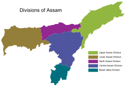
The five divisions of Assam
CountryFlag of India.svg  India
State Assam
Capital Nagaon
Largest City Nagaon
Area
  Total21,001 km2 (8,109 sq mi)
Population
 (2011 census)
  Total4,949,646
  Density240/km2 (610/sq mi)

Hills and Central Assam division is an administrative division of Assam under the jurisdiction of a Division Commissioner, who is officially stationed at Nagaon. It consists of the following districts: Dima Hasao, Karbi Anglong, West Karbi Anglong, Hojai, Nagaon and Marigaon.

Related Research Articles

<span class="mw-page-title-main">Karbi Anglong district</span> District of Assam in India

Karbi Anglong district is one of the 34 administrative districts of Assam in India. Diphu is the administrative headquarter of the district. The district is administered by Karbi Anglong Autonomous Council according to the Sixth Schedule of the Constitution of India.

<span class="mw-page-title-main">Dima Hasao district</span> District of Assam in India

Dima Hasao district, is an administrative district in the state of Assam, India. As of 2011, it is the least populous district of Assam.

<span class="mw-page-title-main">Nagaon district</span> District of Assam in India

Nagaon district is an administrative district in the Indian state of Assam. At the time of the 2011 census it was the most populous district in Assam, before Hojai district was split from it in 2016.

<span class="mw-page-title-main">Karbi people</span> Ethnic group in north-east India

The Karbis or Mikir are one of the major ethnic community in Northeast India. They are mostly concentrated in the hill districts of Karbi Anglong and West Karbi Anglong of Assam.

<span class="mw-page-title-main">Nagaon</span> Town in Assam, India

Nagaon is a town and a municipal board in Nagaon district in the Indian state of Assam. It is situated 122.6 kilometres (76 mi) east of Guwahati.

<span class="mw-page-title-main">Physical geography of Assam</span>

This article discusses the geological origin, geomorphic characteristics, and climate of the northeastern Indian state of Assam. Extending from 89° 42′ E to 96° E longitude and 24° 8′ N to 28° 2′ N latitude, it has an area of 78,438 km2, similar to that of Ireland or Austria.

Kaliabor, a sub-division town in Nagaon district of Assam situated at a distance of 48 km east of Nagaon town. It was the headquarters of Borphukans during the Ahom era. Kaliabor lies in the middle of assam and surrounded in the north by the Brahmaputra, in the south by the hills of Karbi Anglong district, in the east by Kaziranga National Park under Golaghat district and in the west by Samaguri under Nagaon Sadar Sub-Division.

<span class="mw-page-title-main">Karbi Longri North Cachar Hills Liberation Front</span>

Karbi Longri N.C. Hills Liberation Front was a militant group operating in Karbi Anglong district and Dima Hasao district of Assam, India. Thong Teron was the general secretary of KLNLF. Karbi Anglong NC Hills People's Resistance was the armed wing of the organization. KLNLF emerged from the United People's Democratic Solidarity, being against the peace talks between the UDPS and the government. After the split, there has been turf wars between the two groups.

<span class="mw-page-title-main">Karbi language</span> South Asian language

The Karbi language is spoken by the Karbi people of Northeastern India.

<span class="mw-page-title-main">Dimaraji</span> Proposed state in India

Some Dimasa-Cachar people of northeast India have been demanding a separate state called Dimaraji or "Dimaland" for several decades. It would comprise the Dimasa-inhabited areas, namely Dima Hasao district, parts of Cachar district, parts of Nagaon district, Hojai district and Karbi Anglong district in Assam together with part of Dimapur district in Nagaland.

<span class="mw-page-title-main">Kopili River</span> River in India

Kopili River is an interstate river in Northeast India that flows through the states of Meghalaya and Assam and is the largest south bank tributary of the Brahmaputra in Assam.

All Tai Ahom Students Union (ATASU) or Chom Hom Lik Hen Tai Ahom Tang Mung in Ahom language is a students' union in Assam, India.

Assam – 16th largest, 15th most populous and 26th most literate state of the 28 states of the democratic Republic of India. Assam is at 14th position in life expectancy and 8th in female-to-male sex ratio. Assam is the 21st most media exposed states in India. The Economy of Assam is largely agriculture based with 69% of the population engaged in it. Growth rate of Assam's income has not kept pace with that of India's during the Post-British Era; differences increased rapidly since the 1970s. While the Indian economy grew at 6 percent per annum over the period of 1981 to 2000, the same of Assam's grew only by 3.3 percent.

<span class="mw-page-title-main">West Karbi Anglong district</span> District of Assam, India

The West Karbi Anglong district is a district formed out of the existing Donka circle of Karbi Anglong district of Assam in 2016. Hamren is the headquarter of the newly formed district. The district is part of Karbi Anglong Autonomous Council and administered according to the provisions of Sixth Scheduled of the Indian Constitution.

<span class="mw-page-title-main">Baithalangso Assembly constituency</span> Constituency of the Assam legislative assembly in India

Baithalangso Assembly constituency is one of the 126 constituencies of the Assam Legislative Assembly in India. Baithalangso is in West Karbi Anglong district of Assam and forms a part of the Autonomous District Lok Sabha constituency. This seat is reserved for the Scheduled Tribes (ST).

<span class="mw-page-title-main">Karbi Anglong Autonomous Council</span> An autonomous district council in Assam, India

Karbi Anglong Autonomous Council (KAAC) is an autonomous district council in the state of Assam, India for development and protection of tribals living in area namely Karbi Anglong and West Karbi Anglong district. The council is constituted under the Sixth Schedule of the Constitution of India and administratively functions under the Government of Assam. It was formed with the name Karbi Anglong District Council on 17 November 1951. Later changed to Karbi Anglong Autonomous Council on 23 June 1952, which is now celebrated as its foundation day. After Signing of M.O.U. between Government of India, Government of Assam and United People's Democratic Solidarity, it was renamed to Karbi Anglong Autonomous Territorial Council. It has administrative functions over two district, Karbi Anglong district and West Karbi Anglong district. Its headquarters is in Diphu, Karbi Anglong district. The total area of the Karbi Anglong Autonomous Council is 10,434 sq. km having a population of 961,275 as of 2011.

The Diju River is a sub- tributary of the Brahmaputra River in the Indian state of Assam.

Komorakata is a village situated in Hojai district state of Assam, India. According to the 2011 Census of India, it has a population of 3,357. Komorakata village, most of the village population is from Schedule Tribe (ST). It is 6 km away from West Karbi Anglong district. Its PIN code is 782435.

On 22 April 2021, an underage housemaid, Sumila Ronghangpi was found charred to death in her employer's house in Raha, Assam. She was resident of West Karbi Anglong district.

References