Nevada City is the county seat of Nevada County, California, United States, 60 miles (97 km) northeast of Sacramento, 84 miles (135 km) southwest of Reno and 147 miles (237 km) northeast of San Francisco. The population was 3,068 as of the 2010 Census.

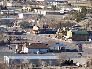
Beatty is an unincorporated town along the Amargosa River in Nye County in the U.S. state of Nevada. U.S. Route 95 runs through the town, which lies between Tonopah, about 90 miles (140 km) to the north and Las Vegas, about 120 miles (190 km) to the southeast. State Route 374 connects Beatty to Death Valley National Park, about 8 miles (13 km) to the west.

Tonopah is an unincorporated town in, and the county seat of, Nye County, Nevada, United States. It is located at the junction of U.S. Routes 6 and 95, approximately midway between Las Vegas and Reno. In the 2010 census, the population was 2,478. The census-designated place (CDP) of Tonopah has a total area of 16.2 square miles (42 km2), all land.

Goldfield is an unincorporated small desert city and the county seat of Esmeralda County, Nevada.

The Tonopah Test Range is a highly classified, restricted military installation of the United States Department of Defense, and United States Department of Energy located about 30 miles (48 km) southeast of Tonopah, Nevada. It is part of the northern fringe of the Nellis Range, measuring 625 sq mi (1,620 km2). Tonopah Test Range is located about 70 miles (110 km) northwest of Groom Lake, the home of the Area 51 facility.

Rhyolite is a ghost town in Nye County, in the U.S. state of Nevada. It is in the Bullfrog Hills, about 120 miles (190 km) northwest of Las Vegas, near the eastern boundary of Death Valley National Park. The town began in early 1905 as one of several mining camps that sprang up after a prospecting discovery in the surrounding hills. During an ensuing gold rush, thousands of gold-seekers, developers, miners and service providers flocked to the Bullfrog Mining District. Many settled in Rhyolite, which lay in a sheltered desert basin near the region's biggest producer, the Montgomery Shoshone Mine.

The Virginia and Truckee Railroad is a privately owned heritage railroad, headquartered in Virginia City, Nevada. Its private and publicly owned route is 14 miles (23 km) long. When first constructed in the 19th century, it was a commercial freight railroad which was originally built to serve the Comstock Lode mining communities of northwestern Nevada.

The Arizona Historical Society (AHS) is a non-profit organization whose mission is to connect people through the power of Arizona's history. It does this through four regional divisions. Each division has a representative museum. The statewide divisions are as follows: Southern Arizona Division in Tucson, the Central Arizona Division in Tempe, the Northern Arizona Division in Flagstaff, and the Rio Colorado Division in Yuma. It was founded in 1884.

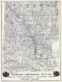
The Tonopah and Tidewater Railroad was a former class II railroad that served eastern California and southwestern Nevada.

Manhattan is an unincorporated town in Nye County, Nevada, located at the end of Nevada State Route 377, about 50 miles (80 km) north of Tonopah, the county seat.
Kašperské Hory is a town in Klatovy District in the Plzeň Region of the Czech Republic. It has about 1,400 inhabitants. It lies in the Bohemian Forest Range, some 65 km (40 mi) south of the region's capital of Plzeň. It is known as a ski resort. The town centre is well preserved and is protected by law as an urban monument zone.

Gold Center was a mining town in Nye County, Nevada. Located in the Bullfrog Mining District south of Tonopah, Gold Center was established in December 1904 with a United States Post Office being authorized on January 21, 1905. The town began publishing its own newspaper in 1907. The location of the town was ideal as it was on the stagecoach route to Rhyolite and Beatty. It was also near the Amargosa River, allowing sufficient water for drinking and for two mills and an ice house. Gold Center also sold water to Rhyolite and Carrara. The Tonopah and Tidewater Railroad, the Las Vegas & Tonopah Railroad and the Bullfrog Goldfield Railroad all ran through Gold Center. Gold Center also had the first brewery in the area which was built underground to maintain a cool temperature.
Blair, Nevada is a mining ghost town in Esmeralda County, Nevada.

The Nevada Test and Training Range (NTTR) is one of two military training areas at the Nellis Air Force Base Complex in Nevada and used by the United States Air Force Warfare Center at Nellis Air Force Base. The NTTR land area includes a "simulated Integrated Air Defense System", several individual ranges with 1200 targets, and 4 remote communication sites. The current NTTR area and the range's former areas have been used for aerial gunnery and bombing, for nuclear tests, as a proving ground and flight test area, for aircraft control and warning, and for Blue Flag, Green Flag, and Red Flag exercises.

The History of Nevada as a state began when it became the 36th state on October 31, 1864, after telegraphing the Constitution of Nevada to the Congress days before the November 8 presidential election. Statehood was rushed to help ensure three electoral votes for Abraham Lincoln's reelection and add to the Republican congressional majorities.

Nevada during World War II was a time of great change that began immediately after the Japanese attack on Pearl Harbor, Hawaii, in December 1941. The population of Nevada grew significantly, largely due to an influx of service men who were stationed at several newly built military bases. The economy also improved as the number of workers steadily increased and new jobs became available.

The Nellis Air Force Base Complex is the southern Nevada military region of federal facilities and lands, e.g., currently and formerly used for military and associated testing and training such as Atomic Energy Commission atmospheric nuclear detonations of the Cold War. The largest land area of the complex is the Nevada Test and Training Range, and numerous Formerly Used Defense Sites remain federal lands of the complex. Most of the facilities are controlled by the United States Air Force and/or the Bureau of Land Management, and many of the controlling units are based at Creech and Nellis Air Force Bases. Initiated by a 1939 military reconnaissance for a bombing range, federal acquisition began in 1940, and McCarran Field became the World War II training area's 1st of 3 Nevada World War II Army Airfields and 10 auxiliary fields. The area's first military unit was initially headquartered in the Las Vegas Federal Building while the WWII Las Vegas Army Airfield buildings were constructed.

The Cave Creek Museum is a 501(c)(3) non-profit entity at the base of the Black Mountains in the town of Cave Creek in Maricopa County, Arizona, United States. The museum preserves artifacts of the prehistory and objects related to the culture of the Cave Creek/Carefree foothills area. The museum consists of various exhibits, indoor and outdoor. Among the outdoor exhibits are the first church of Cave Creek and the last tubercular cabin in the state of Arizona.

Beatty Museum, also known as Beatty Museum and Historical Society, is a volunteer-run local history museum in Beatty, Nevada that showcases the history of the Bullfrog mining district, including its townspeople and their way of life. The museum was founded in 1995 and has experienced several changes in location since its founding.

The Tonopah Historic Mining Park is a defunct mining area in Tonopah, Nevada, that now serves as a museum and historical site. The site covers 113-acre of land. It is currently operated by the non-profit foundation named after the park.


