Related Research Articles

Inverell is a large town in northern New South Wales, Australia, situated on the Macintyre River, close to the Queensland border. It is also the centre of Inverell Shire. Inverell is located on the Gwydir Highway on the western slopes of the Northern Tablelands. It has a temperate climate. In the 2021 census, the population of Inverell was 12,057 and the Inverell Shire population was 17,853.
Scottsdale, formerly known as Ellesmere, is a town in the north-east of Tasmania, Australia. It lies on the Tasman Highway, around 63 kilometres (39 mi) north-east of Launceston and 22 km (14 mi) south-east of the coastal town of Bridport. It is part of the Dorset Council.
Laverton, originally known as British Flag, is a town in the Goldfields region of Western Australia, and the centre of administration for the Shire of Laverton. The town of Laverton is located at the western edge of the Great Victoria Desert, 957 kilometres (595 mi) north-northeast of the state capital, Perth, and 124 kilometres (77 mi) east-northeast of the town of Leonora, with an elevation of 461 metres (1,512 ft).

Salmon Gums is a small town in Western Australia located 106 km north of Esperance on the Coolgardie-Esperance Highway. The name is derived from a prominent stretch of Eucalyptus salmonophloia trees which formed a landmark in the town's early days. The town is part of the Shire of Esperance. At the 2016 census, Salmon Gums had a population of 191.

Onslow is a coastal town in the Pilbara region of Western Australia, 1,386 kilometres (861 mi) north of Perth. It has a population of 848 people and is located within the Shire of Ashburton local government area.

Australia's climate is governed mostly by its size and by the hot, sinking air of the subtropical high pressure belt. This moves north-west and north-east with the seasons. The climate is variable, with frequent droughts lasting several seasons, thought to be caused in part by the El Niño-Southern Oscillation. Australia has a wide variety of climates due to its large geographical size. The largest part of Australia is desert or semi-arid. Only the south-east and south-west corners have a temperate climate and moderately fertile soil. The northern part of the country has a tropical climate, varying between grasslands and desert. Australia holds many heat-related records: the continent has the hottest extended region year-round, the areas with the hottest summer climate, and the highest sunshine duration.
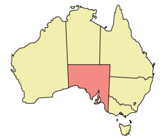
The geography of South Australia incorporates the south central part of the continent of Australia. It is one of the six states of Australia. South Australia is bordered on the west by Western Australia, to the north by the Northern Territory, Queensland to the northeast, and both New South Wales and Victoria to the east. South Australia's south coast is flanked by the Great Australian Bight and the Southern Ocean.
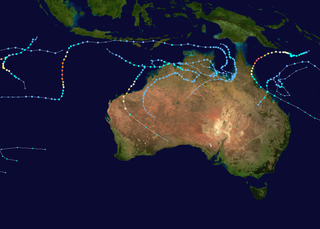
An Australian region tropical cyclone is a non-frontal, low-pressure system that has developed within an environment of warm sea surface temperatures and little vertical wind shear aloft in either the Southern Indian Ocean or the South Pacific Ocean. Within the Southern Hemisphere there are officially three areas where tropical cyclones develop on a regular basis: the South-West Indian Ocean between Africa and 90°E, the Australian region between 90°E and 160°E, and the South Pacific basin between 160°E and 120°W. The Australian region between 90°E and 160°E is officially monitored by the Australian Bureau of Meteorology, the Indonesian Meteorology, Climatology, and Geophysical Agency, and the Papua New Guinea National Weather Service, while others like the Fiji Meteorological Service and the United States National Oceanic and Atmospheric Administration also monitor the basin. Each tropical cyclone year within this basin starts on 1 July and runs throughout the year, encompassing the tropical cyclone season, which runs from 1 November and lasts until 30 April each season. Within the basin, most tropical cyclones have their origins within the South Pacific convergence zone or within the Northern Australian monsoon trough, both of which form an extensive area of cloudiness and are dominant features of the season. Within this region a tropical disturbance is classified as a tropical cyclone when it has 10-minute sustained wind speeds of at least 65 km/h (40 mph) that wrap halfway around the low level circulation centre, while a severe tropical cyclone is classified when the maximum 10-minute sustained wind speeds are greater than 120 km/h (75 mph).

Tasmania has a cool temperate climate with four distinct seasons. The highest recorded maximum temperature in Tasmania is 42.2 °C (108.0 °F) at Scamander on 30 January 2009, during the 2009 southeastern Australia heat wave. Tasmania's lowest recorded minimum temperature is −14.2 °C (6.4 °F) on 7 August 2020, at Central Plateau.

The 1996–97 Australian region cyclone season was an above average tropical cyclone season. It ran from 1 November 1996 to 30 April 1997. The regional tropical cyclone operational plan also defines a tropical cyclone year separately from a tropical cyclone season, and the "tropical cyclone year" ran from 1 July 1996 to 30 June 1997.

The geography of Queensland in the north-east of Australia, is varied. It includes tropical islands, sandy beaches, flat river plains that flood after monsoon rains, tracts of rough, elevated terrain, dry deserts, rich agricultural belts and densely populated urban areas.

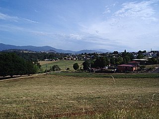
Liawenee is a small town in Tasmania, Australia built near Great Lake and the River Ouse, and was established on 11 June 1920. The town is an ex-Hydro village and now a residence for Inland Fisheries Services (IFS) and a Tasmania Police station. It is known for its exceptional fishing at nearby Great Lake and hosts several trout fishing events.
The 2013–14 Australian region cyclone season was a slightly below-average tropical cyclone season, with 10 tropical cyclones occurring within the Australian region. It officially started on 1 November 2013, and ended on 30 April 2014. The regional tropical cyclone operational plan defines a "tropical cyclone year" separately from a "tropical cyclone season"; the "tropical cyclone year" began on 1 July 2013 and ended on 30 June 2014.
Perth, the capital city of the state of Western Australia, has a Mediterranean climate, with hot, dry summers and mild, wet winters. February is the hottest month of the year, with an average high of 31.6 °C (88.9 °F), and July is the coldest month of the year, with an average low of 7.9 °C (46.2 °F). 77% of rain in Perth falls between May and September. Perth has an average of 8.8 hours of sunshine per day, which equates to around 3,200 hours of annual sunshine, and 138.7 clear days annually, making it the sunniest capital city in Australia.

Brisbane has a humid subtropical climate with year-round period with warm to hot temperatures. Brisbane generally experiences 3 months of mild cool winter from June to August.
References
- ↑ "Archived copy" (PDF). Archived from the original (PDF) on 20 March 2011. Retrieved 27 February 2011.
{{cite web}}: CS1 maint: archived copy as title (link) - ↑ "Centre Island". Climate statistics for Australian locations. Bureau of Meteorology. December 2013. Retrieved 4 December 2013.
- ↑ "Climate statistics for Australian locations- CENTRE ISLAND". 7 April 2024.
15°41′S136°47′E / 15.683°S 136.783°E
Islands of the Northern Territory | |
|---|---|
| | This Northern Territory geography article is a stub. You can help Wikipedia by expanding it. |