This article describes the history of the Australian colony and state of Victoria.

Allan Cunningham was an English botanist and explorer, primarily known for his travels in Australia to collect plants.

John Septimus Roe was the first Surveyor-General of Western Australia. He was a renowned explorer, a member of Western Australia's legislative and executive councils for nearly 40 years.

Melville Island is an island in the eastern Timor Sea, off the coast of the Northern Territory, Australia. Along with Bathurst Island and nine smaller uninhabited islands, it forms part of the group known as the Tiwi Islands, which are under the jurisdiction of the Northern Territory in association with the Tiwi Land Council as the regional authority.

Admiral Phillip Parker King, FRS, RN was an early explorer of the Australian and Patagonian coasts.

Port Essington is an inlet and historic site located on the Cobourg Peninsula in the Garig Gunak Barlu National Park in Australia's Northern Territory. It was the site of an early attempt at British settlement, but now exists only as a remote series of ruins.
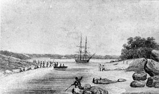
Phillip Parker King's first exploring and surveying expedition departed Sydney on 22 December 1817 on board the cutter HMS Mermaid. On board were King, his two master's mates Frederick Bedwell and John Septimus Roe, the botanist Allan Cunningham, 12 seamen, 2 boys and the native Boongaree. The purpose of the voyage was to explore and make a rough survey of the northern and north-west coasts of Australia.

The Austronesian Makassar people from the region of Sulawesi began visiting the coast of northern Australia sometime around the early to middle 1700s, first in the Kimberley region, and some decades later in Arnhem Land.
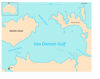
Van Diemen Gulf is a gulf in the Northern Territory of Australia. It connects to the Timor Sea in the north via Dundas Strait. Most of its area is also gazetted as a locality with the name Van Diemen Gulf.

John Clements Wickham was a Scottish explorer, naval officer, magistrate and administrator. He was first officer on HMS Beagle during its second survey mission, 1831–1836, under captain Robert FitzRoy. The young naturalist and geologist Charles Darwin was a supernumerary on the ship, and his journal was published as The Voyage of the Beagle. After that expedition, Wickham was promoted to Commander and made captain of the Beagle on its third voyage, from 1837 and conducted various maritime expeditions and hydrographic surveys along the Australian coastline.
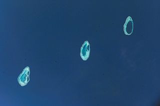
The Rowley Shoals is a group of three atoll-like coral reefs south of the Timor Sea, about 260 km (160 mi) west of Broome on the northwestern Australian coast, centered on 17°20′S119°20′E, on the edge of one of the widest continental shelves in the world. Each atoll covers an area of around 80 to 90 km2 within the rim of the reef, including the lagoons, while the land areas are negligible. They belong to Western Australia. They all rise steeply from the surrounding ocean floor. To the northeast lie the Scott and Seringapatam Reefs which are located on the same undersea platform.

Broughton Island is an island 14 km north-east of Port Stephens, New South Wales, Australia. It is part of the Myall Lakes National Park.(map)

Camden Sound is a relatively wide body of water in the Indian Ocean located in the Kimberley region of Western Australia. The Sound is bounded by the Bonaparte Archipelago to the north-east, the Buccaneer Archipelago to the south-west, and Montgomery Reef to the south.

A number of states and polities formerly claimed colonies and territories in Canada prior to the evolution of the current provinces and territories under the federal system. North America prior to colonization was occupied by a variety of indigenous groups consisting of band societies typical of the sparsely populated North, to loose confederacies made up of numerous hunting bands from a variety of ethnic groups, to more structured confederacies of sedentary farming villages, to stratified hereditary structures centred on a fishing economy. The colonization of Canada by Europeans began in the 10th century, when Norsemen explored and, ultimately unsuccessfully, attempted to settle areas of the northeastern fringes of North America. Early permanent European settlements in what is now Canada included the late 16th and 17th century French colonies of Acadia and Canada, the English colonies of Newfoundland (island) and Rupert's Land, the Scottish colonies of Nova Scotia and Port Royal.

Raffles Bay is a bay on the northern coast of the Cobourg Peninsula of the Top End of the Northern Territory of Australia. It was named in 1818 by explorer Phillip Parker King after Sir Thomas Stamford Raffles, the founder of Singapore. It is about 10 km long north to south, 5 km wide at its mouth and 3 km wide at its inland end. It lies about 210 km north-east of Darwin and opens on to the northern end of Bowen Strait, between the Cobourg Peninsula and Croker Island, and the Arafura Sea. It was the site of an abortive attempt to establish the British military outpost and settlement of Fort Wellington, which lasted only two years, from 1827 to 1829. The surrounds of the bay are largely uninhabited; it now lies within the Garig Gunak Barlu National Park.
The Makassar or Makassarese people are an ethnic group that inhabits the southern part of the South Peninsula, Sulawesi in Indonesia. They live around Makassar, the capital city of the province of South Sulawesi, as well as the Konjo highlands, the coastal areas, and the Selayar and Spermonde islands. They speak Makassarese, which is closely related to Buginese and also a Malay creole called Makassar Malay.

The European exploration of Australia first began in February 1606, when Dutch navigator Willem Janszoon landed in Cape York Peninsula and on October that year when Spanish explorer Luís Vaz de Torres sailed through, and navigated, Torres Strait islands. Twenty-nine other Dutch navigators explored the western and southern coasts in the 17th century, and dubbed the continent New Holland.
Vernon Islands is a locality in the Northern Territory of Australia located over land and water in the Clarence Strait including the Vernon Islands and which is located about 55 kilometres (34 mi) north-east of the territory capital of Darwin.
Bynoe Harbour is a locality in the Northern Territory of Australia located about 41 kilometres (25 mi) south-west of the territory capital of Darwin.

Vernon Islands, also known as the Potinga Islands, is an island group in the Northern Territory of Australia located in the Clarence Strait about 55 kilometres (34 mi) north-east of the territory capital of Darwin. The group consists of three islands which were first sighted in 1818 by Europeans on a British navy ship under the command of Phillip Parker King. The group were part of the subject of a successful aboriginal land claim which was resolved after 40 years in 2018 when the Tiwi people received title. All three islands host navigation aids which assist vessels passing through the Clarence Strait. It and some adjoining seabed have had protected area status since 1974 and which has been known as the Vernon Islands Conservation Reserve since 1979. Since 2007, the island group have been located in the locality of Vernon Islands.
