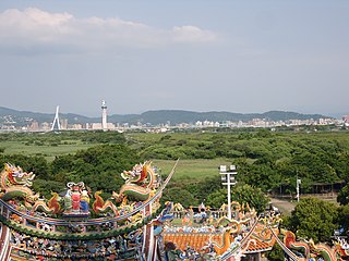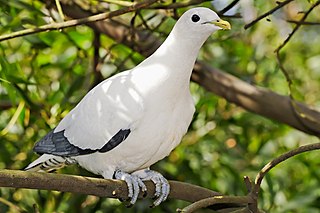
The Brook Islands National Park is a national park in Cassowary Coast Region, Queensland, Australia, 1246 km northwest of Brisbane, with an area of 0.9 km2. It was established in 1994 and comprises three islands - North, Tween and Middle - which lie off the coast 7 km north-east of Cape Richards on Hinchinbrook Island and 30 km east of the nearest mainland town of Cardwell. The fourth island of the Brooks group, South Island, is not part of the national park but is protected by the Great Barrier Reef Marine Park Authority. Public access to the three islands in the national park is prohibited in order to protect breeding birds, especially the Torresian imperial-pigeon. The islands have no roads, walking tracks or other facilities. Popular activities in the waters around the islands are boating, snorkelling and fishing. The islands are managed by the Queensland Parks and Wildlife Service. The Park's IUCN category is II.

Goold Island is a national park in Queensland, Australia, 1,250 km (780 mi) northwest of Brisbane. The island is close to the northern tip of Hinchinbrook Island off the coast from Cardwell in Rockingham Bay and is part of the Great Barrier Reef World Heritage Area.

Swain Reefs is a national park in North Queensland, Australia, 703 km north of Brisbane. It was established in 1995 and covers an area of 0.58 km2. It is managed by the Queensland Parks and Wildlife Service.

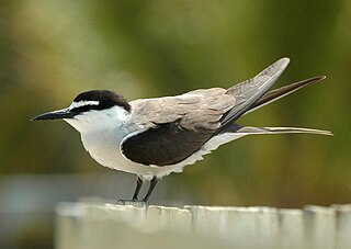
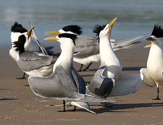
The roseate tern is a tern in the family Laridae. The genus name Sterna is derived from Old English "stearn", "tern", and the specific dougallii refers to Scottish physician and collector Dr Peter McDougall (1777–1814). "Roseate" refers to the bird's pink breast in breeding plumage.

Bremer Island, or Dhambaliya in the local language is an island in the Arafura Sea, in the northwest of the Gulf of Carpentaria, 3.4 km off the northeast corner of Arnhem Land, Northern Territory, Australia.
Blue Mud Bay is a large, shallow, partly enclosed bay on the eastern coast of Arnhem Land, in the Northern Territory of Australia, facing Groote Eylandt on the western side of the Gulf of Carpentaria. It lies 580 km east-south-east of Darwin in the Arnhem Coast bioregion. Its name was given to a landmark court ruling affirming that the Aboriginal traditional owners of much of the Northern Territory's coastline have exclusive rights over commercial and recreational fishing in tidal waters overlying their land.

The Cape York to Cape Grenville Islands comprise ten small islands or island groups, with a total land area of just 210 ha, scattered along the Great Barrier Reef on the eastern side of the northern end of the Cape York Peninsula between Capes York and Grenville, in Queensland, Australia. They are classified by BirdLife International as an Important Bird Area because they support over 1% of the breeding populations of the pied imperial-pigeon, bridled tern, roseate tern and lesser crested tern. Up to 1150 individuals of the migratory wader the grey-tailed tattler have also been recorded.

Haul Round Island is a 6 ha island in the Arafura Sea, lying close to the north central coast of Arnhem Land, in the Northern Territory of Australia. It consists mainly of sand with a few rocks and nearby patches of mangroves. It is close to the town of Maningrida. It has been identified by BirdLife International as an Important Bird Area (IBA) because it has one of the largest seabird colonies in the Northern Territory.

The Islands North of Port Stewart Important Bird Area comprises ten small islands, with a combined area of 137 ha, on the Great Barrier Reef, off the north-eastern coast of the Cape York Peninsula, Queensland, Australia.
The Islet off NE Groote Eylandt Important Bird Area comprises a small (10 ha), unnamed, sand and rock island off the north-eastern coast of Groote Eylandt in the Gulf of Carpentaria, northern Australia. It lies halfway between the north-eastern tip of Groote Eylandt and the North East Islands and is traditionally owned Aboriginal land. It has been identified by BirdLife International as an Important Bird Area (IBA) because it supports over 1% of the world population of roseate terns, with reported numbers of from 2000 to 5500 individual birds present. Up to 500 bridled terns have been recorded nesting there, as well as up to 20 black-naped terns. Marine turtles also nest on the island.

Limmen Bight is a bight, or large, open bay, at the western end of the Gulf of Carpentaria, northern Australia, about 360 km east of the town of Katherine. It is part of the traditional lands and waters of the Marra people. It was named in April 1644 by Abel Tasman for one of his ships on his voyage of exploration along the northern Australian coast. It contains the second largest area of tidal flats in the Northern Territory.
The Low Rocks and Sterna Island Important Bird Area comprises two islets lying about 14 km apart and with a collective area of 14 ha, in the Montesquieu group of islands, in the mouth of Admiralty Gulf in the Kimberley region of Western Australia.

The Lowendal Islands comprise an archipelago, with a total area of about 160 ha of land lying off the coast of Western Australia. It is important for breeding seabirds.
The Pearce, Urquhart and Hervey Islands Important Bird Area consists of three small adjacent islands, with a collective area of 9 ha, in the western Gulf of Carpentaria’s Sir Edward Pellew Group of Islands, in the Northern Territory of Australia. They lie to the north-east of the group's North Island.
The Sandy Island and Low Rock Important Bird Area comprises two small islands with a collective area of 9 ha lying at the western end of the Gulf of Carpentaria in the Northern Territory of Australia. They lie south-west of Groote Eylandt off the coast of Arnhem Land, with the nearest settlement there the Numbulwar community. They are important as breeding sites for terns.
Seagull Island is a 58 ha linear sand island, about 2.5 km long, lying 4 km off Cape Van Diemen on the north-west coast of Melville Island, in the Tiwi Island group, in the Northern Territory of Australia. It is an important breeding site for seabirds.

The South Barnard Islands Important Bird Area comprises a group of two small islands and a sand islet, with a combined area of 15 ha, on the inner Great Barrier Reef, Far North Queensland, Australia. The group lies about 6 km off the coast and 26 km south-east of Innisfail and is protected within the Barnard Island Group National Park. It is an important breeding site for terns.
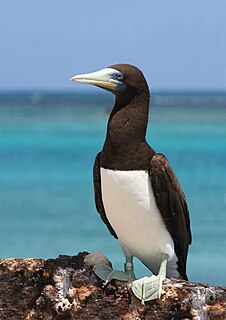
Stapleton Island is a small (4 ha) island on the northern Great Barrier Reef of Far North Queensland, Australia. It lies about 40 km off Cape Melville on the east coast of the Cape York Peninsula. It is important as a nesting site for boobies and terns.

The Three Hummocks Islands are a group of small granite islands, with a collective area of 190 ha, lying off the east coast of Arnhem Land’s Gove Peninsula in the north-western Gulf of Carpentaria, in the Northern Territory of Australia. They are important as a nesting site for terns.
The Anson Bay, Daly and Reynolds River Floodplains comprise some 2,656 square kilometres (1,025 sq mi) of seasonally inundated floodplains around Anson Bay, and the lower reaches of the Daly, Reynolds and Docherty Rivers entering the bay, on the west coast of the Top End of the Northern Territory of Australia. Anson's Bay lies about 120 kilometres (75 mi) south-west of Darwin, on the eastern side of the Joseph Bonaparte Gulf, opening on to the Timor Sea. The site is important for large numbers, and a wide variety, of waterbirds.