
The Northern Mariana Islands, officially the Commonwealth of the Northern Mariana Islands, is an unincorporated territory and commonwealth of the United States consisting of 14 islands in the northwestern Pacific Ocean. The CNMI includes the 14 northernmost islands in the Mariana Archipelago; the southernmost island, Guam, is a separate U.S. territory. The Northern Marianas Islands are listed by the United Nations as one of 17 non-self governing territories.

The Virgin Islands are an archipelago in the Caribbean Sea. They are geologically and biogeographically the easternmost part of the Greater Antilles, the northern islands belonging to the Puerto Rico Trench and St. Croix being a displaced part of the same geologic structure. Politically, the British Virgin Islands have been governed as the western island group of the Leeward Islands, which are the northern part of the Lesser Antilles, and form the border between the Caribbean Sea and the Atlantic Ocean. The archipelago is separated from the true Lesser Antilles by the Anegada Passage and from the main island of Puerto Rico by the Virgin Passage.

Northern Canada, colloquially the North or the Territories, is the vast northernmost region of Canada variously defined by geography and politics. Politically, the term refers to the three territories of Canada: Yukon, Northwest Territories and Nunavut. This area covers about 48 per cent of Canada's total land area, but has less than 1 per cent of Canada's population.

The Anatinae are a subfamily of the family Anatidae. Its surviving members are the dabbling ducks, which feed mainly at the surface rather than by diving. The other members of the Anatinae are the extinct moa-nalo, a young but highly apomorphic lineage derived from the dabbling ducks.

Espiritu Santo is the largest island in the nation of Vanuatu, with an area of 3,955.5 km2 (1,527.2 sq mi) and a population of around 40,000 according to the 2009 census.

The northern elephant seal is one of two species of elephant seal. It is a member of the family Phocidae. Elephant seals derive their name from their great size and from the male's large proboscis, which is used in making extraordinarily loud roaring noises, especially during the mating competition. Sexual dimorphism in size is great. Correspondingly, the mating system is highly polygynous; a successful male is able to impregnate up to 50 females in one season.

Territories of the United States are sub-national administrative divisions overseen by the federal government of the United States. The various American territories differ from the U.S. states and Indian reservations as they are not sovereign entities. In contrast, each state has a sovereignty separate from that of the federal government and each federally recognized Native American tribe possesses limited tribal sovereignty as a "dependent sovereign nation". Territories are classified by incorporation and whether they have an "organized" government through an organic act passed by the Congress. American territories are under American sovereignty and, consequently, may be treated as part of the United States proper in some ways and not others. Unincorporated territories in particular are not considered to be integral parts of the United States, and the Constitution of the United States applies only partially in those territories.

Azania is a name that has been applied to various parts of southeastern tropical Africa. In the Roman period and perhaps earlier, the toponym has been hypothesised to have referred to a portion of the Southeast Africa coast extending from northern Kenya to the border between Mozambique and South Africa. If this is correct, then during classical antiquity Azania was mostly inhabited by Southern Cushitic peoples, whose groups would rule the area until the great Bantu Migration.
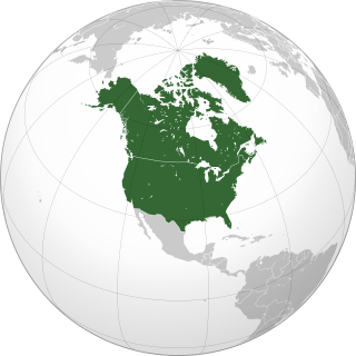
Northern America is the northernmost subregion of North America. The boundaries may be drawn slightly differently. In one definition, it lies directly north of Middle America. Northern America's land frontier with the rest of North America then coincides with the Mexico–United States border. Geopolitically, according to the United Nations' scheme of geographical regions and subregions, Northern America consists of Bermuda, Canada, Greenland, Saint Pierre and Miquelon and the United States.
Charles Brian Montagu McBurney was an American archaeologist who spent most of his working life in England.
Burneyville is an unincorporated community and census-designated place (CDP) in Love County, Oklahoma, United States. The post office was established May 5, 1879. It was named for David C. Burney, father of Benjamin Crooks Burney, who had been Governor of the Chickasaw Nation from 1878 through 1880.

The treaty between Kingdom of Siam and Great Britain commonly known as the Burney Treaty was signed at Bangkok on 20 June 1826 by Henry Burney, an agent of British East India Company, for Britain, and King Rama III for Siam. It followed an earlier treaty of 24 February 1826, in which Siam became an ally of Britain against the Kingdom of Ava (Burma), with which Britain was at war. A Siamese army was raised and equipped, but took no serious part in the war due to ill-feeling and suspicion arising from the Siamese invasion of Kedah in 1821.

The states and territories are federated administrative divisions in Australia, ruled by regional governments that constitute the second level of governance between the federal government and local governments. States are self-governing polities with incomplete sovereignty and have their own constitutions, legislatures, departments, and certain civil authorities that administer and deliver most public policies and programs. Territories can be autonomous and administer local policies and programs much like the states in practice, but are still constitutionally and financially subordinate to the federal government and thus have no true sovereignty.
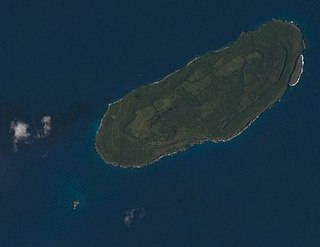
Aguiguan is a small bean-shaped coralline island in the Northern Mariana Islands chain in the Pacific Ocean. It is situated 8 kilometers (5.0 mi) south-west of Tinian, from which it is separated by the Tinian Channel. Aguiguan and neighboring Tinian Island together form Tinian Municipality, one of the four main political divisions that comprise the Northern Marianas.
The XL Ranch is an Indian reservation located in Modoc County, north of Burney, California.

The Makauwahi Cave is the largest limestone cave found in Hawaii. It lies on the south coast of the island of Kauaʻi, in the Māhāʻulepū Valley close to Māhāʻulepū Beach, and is important for its paleoecological and archaeological values. It is reached via a sinkhole and has been described as “…maybe the richest fossil site in the Hawaiian Islands, perhaps in the entire Pacific Island region”.
The Siamese invasion of Kedah was a military operation mounted by the Kingdom of Siam against the Sultanate of Kedah in November 1821, in the area of what is now northern Peninsula Malaysia.
