
The Magallanes Region, officially the Magallanes y la Antártica Chilena Region, is one of Chile's 16 first order administrative divisions. It is the southernmost, largest, and second least populated region of Chile. It comprises four provinces: Última Esperanza, Magallanes, Tierra del Fuego, and Antártica Chilena.

Gurabo is a town and municipality in eastern Puerto Rico. It is located in the central eastern region, north of San Lorenzo; south of Trujillo Alto; east of Caguas; and west of Carolina and Juncos. Gurabo is spread over 9 barrios and Gurabo Pueblo. It is part of the San Juan-Caguas-Guaynabo Metropolitan Statistical Area.
Cerro Maravilla is Puerto Rico's fourth highest peak at 1,205 meters (3,953 ft). It is located on the northern edge Barrio Anón in Ponce, close to the border with the municipality Jayuya, and is part of the Cordillera Central. It is known as El Cerro de los Mártires and characterized as the most infamous peak in Puerto Rico, due to the 1978 Cerro Maravilla murders which took place here.
Southernmost settlements are cities, towns, weather stations or permanent military bases which are farther south than latitude 45°S. They are closely related to the Southern Ocean or either the Roaring Forties or Furious Fifties. Antarctic bases are excluded due to not having a permanent population.
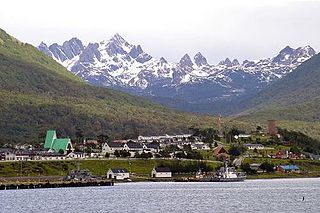
Puerto Williams is the city, port and naval base on Navarino Island in Chile. It faces the Beagle Channel. It is the capital of the Chilean Antarctic Province, one of four provinces in the Magellan and Chilean Antarctica Region, and administers the communes of Chilean Antarctic Territory and Cabo de Hornos. It has a population of 2,874, including both naval personnel and civilians. Puerto Williams claims the title of world's southernmost city. The settlement was founded in 1953, and was first named Puerto Luisa. The town was later named after John Williams Wilson, a British man who founded Fuerte Bulnes, the first settlement in the Strait of Magellan. It has served primarily as a naval base for Chile. The Chilean Navy runs the Guardiamarina Zañartu Airport and hospital, as well as nearby meteorological stations. Since the late 20th century, the number of navy personnel has decreased in Puerto Williams and the civilian population has increased. In that period, tourism and support of scientific research have contributed to an increase in economic activity.

Cerro de Punta or just Cerro Punta is the highest peak in Puerto Rico, rising to 1,338 meters (4,390 ft) above sea level. The mountain is part of the Cordillera Central and is located in the municipality of Ponce.

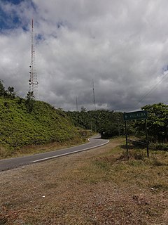
Puerto Toro is a hamlet on the eastern coast of Navarino Island, Chile. Puerto Toro was founded in 1892 during the Tierra del Fuego Gold Rush by Governor of Punta Arenas Señoret.

Cordillera Central, is the main mountain range in Puerto Rico. The range crosses the island from west to east and divides it into its northern and southern coastal plains. The Cordillera Central runs eastward from the municipality of Maricao in the west to Aibonito in the central eastern region, and on to the Caribbean in the southeast through the Sierra de Cayey. The Central Mountain Range consists of the Cordillera Central proper and numerous subranges, foothills and ridges that extend throughout the island. Cerro de Punta is both the highest peak of the Cordillera Central and the highest point in Puerto Rico. The Sierra de Luquillo, where El Yunque is located, is sometimes included as a subrange or eastward extension of the Cordillera Central.

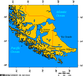
Navarino Island is a Chilean island located between Isla Grande de Tierra del Fuego, to the north, and Cape Horn, to the south. The island forms part of the Commune of Cabo de Hornos, the southernmost commune in Chile and in the world, belonging to Antártica Chilena Province in the XII Region of Magallanes and Chilean Antarctica. Its population is concentrated primarily in the communal capital, Puerto Williams, and in small settlements like Puerto Navarino, Río Guanaco and Puerto Toro. The highest point of the island is Pico Navarino at 1,195 m (3,921 ft). The island is a popular destination for fly-fishers.

The Roman Catholic Diocese of Punta Arenas is a suffragan diocese of the Archdiocese of Puerto Montt, in Chile. Its current bishop is Mgr. Óscar Hernán Blanco Martínez, O.M.D.

Guardia Marina Zañartu Airport is an airport serving the town of Puerto Williams on the north shore of Navarino Island in the Magallanes Region of Chile. The island is at the southern tip of Chile, and is across a narrow strait from Argentina called Beagle Channel. It is the world's southernmost airport with regular scheduled flights.
Puerto Navarino is a Chilean port on the Beagle Channel in western Navarino Island opposite Ushuaia in Argentina. Puerto Navarino is part of Cabo de Hornos commune. It is 54km west of Puerto Williams along a gravel road. It is one of the most southerly populated places in Chile.

Dientes de Navarino are a mountain range in Navarino Island, Chile, located just south of Puerto Williams, along the Beagle Channel coast. They are named for the jagged pinnacles which resemble teeth.
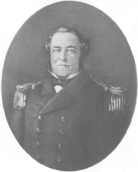
John Williams Wilson (1798–1857), also known as Juan Guillermos, was an English-Chilean sailor and politician. Born in Bristol, he entered the newly founded Chilean navy in 1824 and rose to the rank of commander. He was appointed governor of Talcahuano (1849–1855). He supervised construction of Fuerte Bulnes in 1843, which the government intended for a settlement at the Strait of Magellan. Puerto Williams, founded in 1953, was named for the naval commander.

Bandera News Philippines is a regional broadcast company in the Philippines. Its main headquarters is located in Macasaet Business Complex, Roxas St., Puerto Princesa. Bandera News operates a number of stations across the country under the Radyo Bandera brand, with Fairwaves Broadcasting Network serving as its licensee. It also operates its own television station in Palawan named Bandera News TV.

Matamoros Lighthouse is a defunct lighthouse along Matamoros Street, in colonia Centro, Puerto Vallarta, in the Mexican state of Jalisco. A beacon, the structure was built by Roberto Alcazar and inaugurated on August 15, 1932. It operated until June 1978, and upon retirement, was deemed a historic landmark.

The Cerro Bandera Formation is a geological formation in Neuquén Province, Argentina, in northern Patagonia, which dates to the Early Miocene, around 21 to 17.5 million years ago. It predominantly consists of pyroclastic deposits, which were deposited in a semi-arid environment. It is divided up into a number of members. The diverse fauna of the Cerro Bandera Formation include a variety of turtles and birds, also includes many mammals such as South American native ungulates as well as armadillos, and caviomorph rodents.
