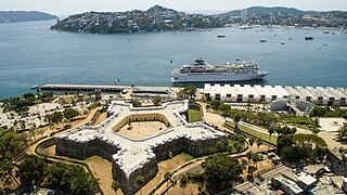
Acapulco de Juárez, commonly called Acapulco, is a city and major seaport in the state of Guerrero on the Pacific Coast of Mexico, 380 kilometres (240 mi) south of Mexico City. Located on a deep, semicircular bay, Acapulco has been a port since the early colonial period of Mexico's history. It is a port of call for shipping and cruise lines running between Panama and San Francisco, California, United States. The city of Acapulco is the largest in the state, far larger than the state capital Chilpancingo. Acapulco is also Mexico's largest beach and balneario resort city. Acapulco de Juárez, Guerrero is the municipal seat of the municipality of Acapulco, Guerrero.

Zacatecas is the principal city within the municipality in Mexico of the same name, and the capital of the state of Zacatecas. Located in north-central Mexico, the city had its start as a Spanish mining camp in the mid-16th century. Native Americans had already known about the area's rich deposits of silver and other minerals. Due to the wealth that the mines provided, Zacatecas quickly became one of the most important mining cities in New Spain. The area saw battles during the turbulent 19th century, but the next major event was the Battle of Zacatecas during the Mexican Revolution when Francisco Villa captured the town, an event still celebrated every anniversary. Today, the colonial part of the city is a World Heritage Site, due to the Baroque and other structures built during its mining days. Mining still remains an important industry. The name Zacatecas is derived from the Zacateco people and has its roots in Nahuatl. The name means "people of the grasslands".

Guerrero, officially the Free and Sovereign State of Guerrero, is one of the 32 states that comprise the 32 Federal Entities of Mexico. It is divided into 81 municipalities. The state has a population of about 3.5 million people. It is located in southwest Mexico and is bordered by the states of Michoacán to the north and west, the State of Mexico and Morelos to the north, Puebla to the northeast and Oaxaca to the east. In addition to the capital city, Chilpancingo and the largest city Acapulco, other cities in Guerrero include Petatlán, Ciudad Altamirano, Taxco, Iguala, Ixtapa, and Zihuatanejo. Today, it is home to a number of indigenous communities, including the Nahuas, Mixtecs, Tlapanecs, Amuzgos, and formerly Cuitlatecs. It is also home to communities of Afro-Mexicans in the Costa Chica region.
Amacuzac is a city in the Mexican state of Morelos. The name means In the River of Yellow Amates. Amacuzac stands at 18°36′N99°23′W, at a mean height of 900 meters above sea level. The city serves as the municipal seat for the surrounding municipality of the same name. The municipality reported 17,772 inhabitants in the year 2015 census and covers a total surface area of 125 km2. The 2020 census reported 17,598 inhabitants in the municipality and 5,575 in the city of Amacuzac.

Guerrero is a state in Southwest Mexico that is divided into 85 municipalities. According to the 2020 Mexican census, Guerrero is the 13th most populous state with 3,540,685 inhabitants and the 14th largest by land area spanning 63,803.42 square kilometres (24,634.64 sq mi).
Totolapan is a municipality in the north of the Mexican state of Morelos, surrounded by the State of Mexico to the north; to the south with Tlayacapan and Atlatlahucan; to the east and southeast with Atlatlahucan; and to the west with Tlalnepantla.

Zacatepec de Hidalgo is a town in the state of Morelos, Mexico. It is bordered by Puente de Ixtla, Tlaltizapán, Tlaquiltenango and Jojutla. Miguel Hidalgo was the priest whose call to arms on September 16, 1810, led to the Mexican War of Independence.

The Sierra Madre del Sur is a mountain range in southern Mexico, extending 1,000 kilometres (620 mi) from southern Michoacán east through Guerrero, to the Isthmus of Tehuantepec in eastern Oaxaca.

The Cumbres de Majalca National Park is a national park in the Mexican state of Chihuahua located 88 km northwest of the city of Chihuahua. The park showcases extraordinary rock formations that have been shaped by wind and water erosion. The park was created by presidential decree in 1939 encompassing 4,772 hectares to protect the endemic flora and fauna. The park is characterized by pine and oak forest. It is also one of the few areas in Mexico that are inhabited by black bear.

The Cerro de las Mitras, is a mountain and a protected area in the Monterrey, San Pedro Garza García, Santa Catarina and García municipalities; state of Nuevo León, México. The mountain is part of the Sierra Madre Oriental, the summit reaches 2,058 MASL, and has 1,303 meters of prominence, the topographic isolation is about 14.48 km. The ridge is about 21 km long stretching east to west. The name comes from the resemblance of the peaks in the ridge with a bishop's mitre.

Mauro Boselli is an Argentine former professional footballer who played as striker.

The Estadio BBVA, formerly known as the Estadio BBVA Bancomer, is an association football stadium Guadalupe, Greater Monterrey, Nuevo León, Mexico. Nicknamed "El Gigante de Acero" in Spanish, the stadium replaced the Estadio Tecnológico as the home of C.F. Monterrey, ending 63 years of residency at that stadium.

Singuilucan is a town and one of the 84 municipalities of Hidalgo, in central-eastern Mexico. The municipality covers an area of 334.1 km². As of 2005, the municipality had a total population of 13,143.

Tolé District is a district (distrito) of Chiriquí Province in Panama. The population according to the 2000 census was 11,563. The district covers a total area of 488 km2. The capital lies at the city of Tolé.
The 2011 Guerrero earthquake struck with a moment magnitude of 5.7 in southern Mexico at on 5 May. It was positioned west of Ometepec, Guerrero, with a focal depth of 24 km (14.9 mi), and was lightly felt in many adjacent areas.

The Battle of El Veladero was a battle of the War of Mexican Independence that occurred from 1810 to 30 April 1811 at Cerro El Veladero, Acapulco de Juárez. The battle was fought between royalist forces loyal to the Spanish crown, commanded by Juan Antonio Fuentes, and Mexican rebels, commanded by José María Morelos and Rafael Valdovinos, fighting for independence from the Spanish Empire. The rebels won.
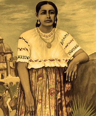
Antonia Nava de Catalán was a woman involved in the Mexican War of Independence. She accompanied her husband, a volunteer who rose to the rank of colonel, throughout the war. Three of her sons were killed in the struggle. She is remembered for her willingness to sacrifice her family and herself to achieve independence from Spain, and came to be known as "La Generala". She fought alongside Jose Maria Morales until her death.
Cerro del Judío, also known as Cerro de las Tres Cruces, or "Mazatepetl" is a mountain located in Magdalena Contreras municipality of Mexico City.
A moment magnitude Mw 7.0 or 7.1 earthquake occurred near the city of Acapulco in the Mexican state of Guerrero at on 7 September with an estimated intensity of VIII (Severe) on the MMI scale. The earthquake killed 13 people and injured at least 23 others. At least 1.6 million people in Mexico were affected by the earthquake which resulted in localized severe damage. The earthquake occurred on the anniversary of the 2017 Chiapas earthquake which measured Mw 8.2. It was also the largest earthquake in Mexico since the 2020 Oaxaca earthquake.

