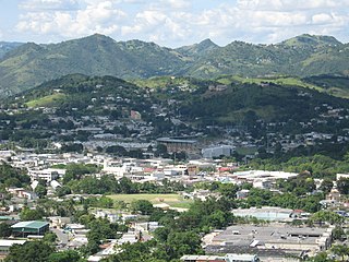
Caguas is a city and municipality of Puerto Rico located in the Central Mountain Range of Puerto Rico, south of San Juan and Trujillo Alto, west of Gurabo and San Lorenzo, and east of Aguas Buenas, Cidra, and Cayey. Caguas was founded in 1775.
Cayey, officially Cayey de Muesas, is a mountain town and municipality in central Puerto Rico located on the Sierra de Cayey within the Central Mountain range, north of Salinas and Guayama; south of Cidra and Caguas; east of Aibonito and Salinas; and west of San Lorenzo. Cayey is spread over 21 barrios plus Cayey Pueblo. It is part of the San Juan-Caguas-Guaynabo Metropolitan Statistical Area.

San Lorenzo is a town and municipality of Puerto Rico located in the eastern central region, north of Patillas and Yabucoa; south of Gurabo; east of Caguas and Cayey; and west of Juncos and Las Piedras. San Lorenzo is spread over twelve barrios and San Lorenzo Pueblo. It is part of the San Juan-Caguas-Guaynabo Metropolitan Statistical Area.

Cerro Las Tetas, nicknamed Las Tetas de Cayey but officially Las Piedras del Collado, are two mountain peaks located in the municipality of Salinas, Puerto Rico, north of the city of Salinas proper. Since September 1, 2000, the peaks have become part of the Las Piedras del Collado Nature Reserve and are protected by law. Their height is 2,762 feet (842 m) above sea level.
Cordillera Central, is the main mountain range in Puerto Rico. The range crosses the island from west to east and divides it into its northern and southern coastal plains. The Cordillera Central runs eastward from the municipality of Maricao in the west to Aibonito in the central eastern region, and on to the Caribbean in the southeast through the Sierra de Cayey. The Central Mountain Range consists of the Cordillera Central proper and numerous subranges, foothills and ridges that extend throughout the island. Cerro de Punta is both the highest peak of the Cordillera Central and the highest point in Puerto Rico. The Sierra de Luquillo, where El Yunque is located, is sometimes included as a subrange or eastward extension of the Cordillera Central.
WXWZ-LD, virtual channel 23, branded on-air as MásTVPR, is a low-powered independent television station licensed to Guayama, Puerto Rico. The station is owned by the JB Media Group. WXWZ-LD serves Caguas and the entire central area. WXWZ-LD's programming was seen on Liberty Cable channel 22, OneLink Communications channel 121 and Choice Cable channel 27. WXWZ-LD produces over 40 hours of locally produced programming that includes: News, Sports and general entertainment. The station's studios are located at Degetau Avenue in Caguas with its transmitter located at Cerro La Santa in Cayey near the Bosque Estatal de Carite mountain reserve.

The Rio Grande de Loíza is a river in the island of Puerto Rico. It is the largest river in Puerto Rico by discharge volume. It is situated on the north coast of the island. It flows from south to north and drains into the Atlantic Ocean, a few miles east of San Juan.
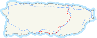
Puerto Rico Highway 1 (PR-1) is a highway in Puerto Rico that connects the city of Ponce to San Juan. Leaving Ponce, the road heads east and follows a somewhat parallel route along the southern coast of the island heading towards Salinas. At Salinas, the road turns north to cut through the Cordillera Central in its approach to San Juan. Before reaching San Juan, it climbs to make its way to the mountain town of Cayey and then it winds down into the city of Caguas on its final approach to San Juan.

Beatriz is a barrio in the municipality of Caguas, Puerto Rico. Its population in 2010 was 4,353.
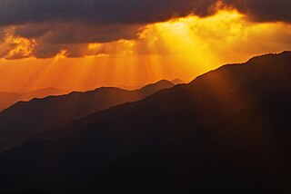
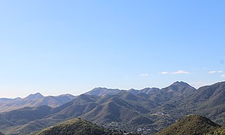
Sierra de Cayey is a mountain range in the main island of Puerto Rico. It is located in the southeast section of the island. Its elevations do not exceed 1000 m.

Carite State Forest is a state forest and nature reserve located in the Sierra de Cayey mountain range in southeastern Puerto Rico. The forest extends over approximately 6,500 acres and is located in the municipalities of Caguas, Cayey, Guayama, Patillas and San Lorenzo. The forest is located along the Ruta Panorámica, which offers access to the forest.
Caguas Valley, or the Caguas-Juncos Valley and popularly referred to as the Turabo Valley, is a large valley lying between the Central Mountain Range and the Sierra de Luquillo in the eastern part of Puerto Rico, immediately south of San Juan.
Sierra de Jájome is a mountain massif of the Sierra de Cayey located in the municipalities of Cayey, Guayama and Salinas in southeastern Puerto Rico. The mountain, often referred to as a mountain range (sierra), is protected as the Jájome Protected Natural Area. The Guayama Research Forest Area is also located on the massif. La Robleda, another protected natural area, is located nearby.

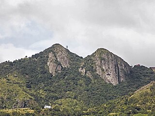
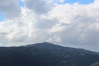
Cerro La Santa is a 2,962 feet high mountain and the highest point in the Sierra de Cayey in Puerto Rico. The peak of Cerro La Santa is located in the Carite State Forest, at a tri-point shared by the municipalities of Caguas, Cayey (Farallón) and San Lorenzo (Espino).

Cerro Planada is a mountain peak located in Cayey, Puerto Rico. The mountain has an elevation of 2,480 feet, making it the 10th highest peak of the Sierra de Cayey.
The Planadas-Yeyesa Nature Reserve is a protected nature reserve located in the Sierra de Cayey, in the municipalities of Cayey and Salinas in central Puerto Rico. The reserve is located close to the famous Cerro Las Tetas. Two of the most prominent features of the reserve are Cerro Planada, a 2,480 feet high mountain peak, and La Yeyesa, a heavily forested canyon formed by the Lapa River and other streams which feed into the Nigua River. La Yeyesa can be accessed through a lightly trafficked yet moderate trail.
Montes Oscuros is a small mountain range located between the Sierra de Cayey and the main Cordillera Central, on the municipalities of Coamo and Salinas in southern Puerto Rico. The mountain range and its environment are protected from urban development through a conservation easement, designated as the Montes Oscuros Scenic Easement.
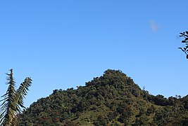
Cerro Las Piñas is a mountain of the Sierra de Cayey located in the boundary between the municipalities of Caguas and Cayey in central Puerto Rico. The summit is located at 2,425 feet above sea level, in the barrios Beatriz of Caguas, and Beatriz and Guavate of Cayey. The summit offers panoramic views of the Valley of Caguas and Cayey.