Cerro Punta, Chiriquí

Last updated • 4 min readFrom Wikipedia, The Free Encyclopedia
Cerro Punta
Panama location map.svg
Red pog.svg
Cerro Punta
Coordinates: 8°51′N82°34′W / 8.850°N 82.567°W / 8.850; -82.567
CountryFlag of Panama.svg  Panama
Province Chiriquí
District Tierras Altas [1] [2]
Area
[3]
  Land105.1 km2 (40.6 sq mi)
Population
 (2010) [3]
  Total7,754
  Density73.8/km2 (191/sq mi)
 Population density calculated based on land area.
Time zone UTC−5 (EST)
Climate Cwb
Cerro Punta, Chiriqui

Cerro Punta is a city and corregimiento in Tierras Altas District, Chiriquí Province, Panama. [1] [2] Cerro Punta is located in Panama's western highlands at an altitude of 6,500 feet (2,000 metres), just south of the Continental Divide. The climate, like the rest of Panama, is tropical with a short dry season and rainy season that extends about 9 – 10 months of the year. Night time temperatures are often cool due to Cerro Punta's relatively high elevation. During the 1970s much of the land was used for cultivating strawberries; households also maintained small mixed-vegetable gardens. The village can be reached by traveling north from the Pan-American highway.

Contents

Toponymy

Cerro Punta is named after a hill with that forms which is the highest point of the village at 2300 meters. The original name Cerro de Punta, original name is credited to the Chircana poet Caval Beatriz Miranda, who taught grade school in Cerro Punta. In the 1940s in a meeting to choose the name of the town said: "Cerro Punta your name is written in your mountains."

Geography

Cerro Punta has a fairly rugged terrain, with small plains, where most people live. Outside the main area of the city the houses are widely spaced and the surrounding area is cultivated.

Chiriqui is the most mountainous and highest province in Panama, and Cerro Punta is the highest town in Chiriqui, with elevations ranging from 2000m to 2200m. As such, it shares the tropical rainforest climate of the rest of Panama, with at least 60mm (>2 inches) of rain every month, but is considerably cooler due to the high elevation.

Typically, the annual temperature range in Cerro Punta is between a low of 14 C in January and a high of 32 C in April. In terms of extremes, on the very coldest days in Cerro Punta, temperatures may go as low as -1 °C (30 F). Temperatures exceeding 37 C are rare.

Winds are typically light for most of the year, but are strongest during the dry (and sunniest) season, late December through early April.

The rainy season in Cerro Punta (like the rest of Panama) is from late April until mid-December, peaking in September, October and November. Most rain occurs in the afternoon.

Hailstorms occasionally cause some damage to crops such as peas, beans, herbs, cucumbers, strawberries, potatoes, lettuce, coffee and others.

Villas

Cerro Punta is divided into several villas such as Guadalupe, Bajo Grande, Entre Ríos, Las Nubes, La Garita, Barrio del Bajito, Las Miranda, Barrio 6, El Pueblo, Las Cumbres, Alto Pineda, El Barrio de la Chacha, Nueva Suiza, Alto Bambito; all of which are situated above 2,000 meters.

Demographics

It has a land area of 105.1 square kilometres (40.6 sq mi) and had a population of 7,754 as of 2010, giving it a population density of 73.8 inhabitants per square kilometre (191/sq mi). [3] Its population as of 1990 was 5,682; its population as of 2000 was 6,860. [3]

60% white and mestizo, 30% indigenous, 10% foreign.[ citation needed ]

Economy

The local economy is based on agriculture. The land is very fertile as a result of being on the slopes of a dormant volcano and due to the cool and moist conditions associated with the higher elevation. Northern Chiriqui has a different kind of climate from the rest of the country, enabling the successful propagation of some crops that would be impossible in the rest of Panama.

Tourism

Tourism has become another source of income in recent years as the region has a temperate climate, relatively cold within one of the tropical regions in the world. This is interesting for nationals living in the rest of the country and for tourists, because one can enjoy the change of climate and different ecosystems on the same day up to the paramo.

At the highest part of Cerro Punta, the village of Guadalupe at 2197 meters, agriculture dominates but agrotourism and ecotourism are increasing as many come to enjoy the climate, flora and fauna of the Parque Internacional La Amistad (Panama and Costa Rica). Hiking and river rafting are popular activities.

Thoroughbred horse farms are being developed in this area due to lower temperatures and the high elevation (lower oxygen content in the air) makes race horses develop better lung capacity, enabling them to compete successfully in international competitions.

Related Research Articles

<span class="mw-page-title-main">Geography of Colombia</span> Overview of the geography of Colombia

The Republic of Colombia is situated largely in the north-west of South America, with some territories falling within the boundaries of Central America. It is bordered to the north-west by Panama; to the east by Brazil and Venezuela; to the south by Ecuador and Peru; and it shares maritime limits with Costa Rica, Nicaragua, Honduras, Jamaica, the Dominican Republic, and Haiti.

<span class="mw-page-title-main">Geography of Honduras</span> Geography of the Central American country

Honduras is a country in Central America. Honduras borders the Caribbean Sea and the North Pacific Ocean. Guatemala lies to the west, Nicaragua south east and El Salvador to the south west. Honduras is the second largest Central American republic, with a total area of 112,890 square kilometres (43,590 sq mi).

<span class="mw-page-title-main">Geography of Panama</span>

Panama is a country located in Central America, bordering both the Caribbean Sea and the Pacific Ocean, between Colombia and Costa Rica. Panama is located on the narrow and low Isthmus of Panama.

<span class="mw-page-title-main">Magallanes Region</span> First-level administrative division of Chile

The Magallanes Region, officially the Magallanes y la Antártica Chilena Region, is one of Chile's 16 first order administrative divisions. It is the southernmost, largest, and second least populated region of Chile. It comprises four provinces: Última Esperanza, Magallanes, Tierra del Fuego, and Antártica Chilena.

<span class="mw-page-title-main">Río Negro Province</span> Province of Argentina

Río Negro is a province of Argentina, located in northern Patagonia. Neighboring provinces are from the south clockwise Chubut, Neuquén, Mendoza, La Pampa and Buenos Aires. To the east lies the Atlantic Ocean.

<span class="mw-page-title-main">Chiriquí Province</span> Province of Panama

Chiriquí is a province of Panama located on the western coast; it is the second most developed province in the country, after the Panamá Province. Its capital is the city of David. It has a total area of 6,490.9 km2, with a population of 462,056 as of the year 2019. The province of Chiriquí is bordered to the north by the province of Bocas del Toro, to the west by Costa Rica, to the east by the province of Veraguas, and to the south by the Pacific Ocean, specifically the Gulf of Chiriquí.

<span class="mw-page-title-main">Los Santos Province</span> Province of Panama

Los Santos is a province in Panama, reaching from the La Villa river in the North to the Pacific Ocean in the south and east. It is part of the Azuero Peninsula, bounded by the province of Herrera to the north and northeast, and by Mariato District of Veraguas Province to the West. The City of Las Tablas is the capital and most populous city. There are seven administrative districts under the jurisdiction of Los Santos Province. Los Santos's area is 3,809.4 km ², and its population is 95,540 inhabitants in 2019.

<span class="mw-page-title-main">Vega Alta, Puerto Rico</span> Town and municipality in Puerto Rico

Vega Alta is a town and municipality of Puerto Rico. Vega Alta is on the northern coast of the island, north of Morovis and Corozal; east of Vega Baja; and west of Dorado with an area of 28 square miles (73 km2). Vega Alta is subdivided into seven barrios and Vega Alta barrio-pueblo. It is part of the San Juan-Caguas-Guaynabo Metropolitan Statistical Area.

<span class="mw-page-title-main">David, Chiriquí</span> City in Chiriquí, Panama

David, known as David City in colonial times, is a city and corregimiento in the west of Panama. It is the capital of the province of Chiriquí and has an estimated population of 82,907 inhabitants as confirmed in 2013. It is a relatively affluent city with a firmly established, dominant middle class and a very low unemployment and poverty index. The Pan-American Highway is a popular route to David. It is named after the Biblical King David. David is the largest city in Panama that is not part of the Panama city metro area.

<span class="mw-page-title-main">Nicoya</span> District in Nicoya canton, Guanacaste province, Costa Rica

Nicoya is a district and head city of the Nicoya canton, in the Guanacaste province of Costa Rica, located on the Nicoya Peninsula. It is one of the country's most important tourist zones; it serves as a transport hub to Guanacaste's beaches and national parks.

<span class="mw-page-title-main">Tlaxiaco</span> City in Oaxaca, Mexico

Tlaxiaco is a city, and its surrounding municipality of the same name, in the Mexican state of Oaxaca. It is located in the Tlaxiaco District in the south of the Mixteca Region, with a population of about 17,450.

Huautla de Jimenez is a town and municipality in the Mexican state of Oaxaca. It is part of the Teotitlán District in the north of the Cañada Region.

San Jose Villa de Allende is a town and municipal seat of the municipality of Villa de Allende. It is the fifth largest town in the municipality. It is located 70 kilometers to the west of the city of Toluca. Villa de Allende was named in honor of Ignacio Allende, a hero of the Mexican War of Independence.

Río Sereno, also known as Sereno, is a town and corregimiento in Renacimiento District, Chiriquí Province, Panama, close to the Costa Rica border. It is the seat of Renacimiento District. It has a land area of 83.2 square kilometres (32.1 sq mi) and had a population of 5,463 as of 2010, giving it a population density of 65.7 inhabitants per square kilometre (170/sq mi). Its population as of 1990 was 2,595; its population as of 2000 was 3,289.

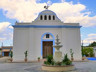
Volcán is a town and corregimiento in Tierras Altas District, Chiriquí Province, Panama. It has a land area of 233.7 square kilometres (90.2 sq mi) and had a population of 12,717 as of 2010, giving it a population density of 54.4 inhabitants per square kilometre (141/sq mi). Its population as of 1990 was 7,146; its population as of 2000 was 10,188.

<span class="mw-page-title-main">San Luis Acatlán (municipality)</span> Municipality in Guerrero, Mexico

San Luis Acatlán is one of the 81 municipalities of Guerrero, in south-western Mexico. The municipal seat lies at San Luis Acatlán. The municipality covers an area of 704.4 km².

<span class="mw-page-title-main">Tierras Altas District</span> District in Chiriquí Province, Panama

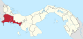
Tierras Altas District is a district (distrito) of Chiriquí Province in Panama. It was created by Law 13 of September 13, 2013, after splitting off from Bugaba District.

<span class="mw-page-title-main">Intibucá, Intibucá</span> Municipality in Intibucá, Honduras

Intibucá is a city, with a population of 28,220, and a municipality in the department of Intibucá, Honduras. The urban area of Intibucá is an important transit and commercial site in the South-West region of Honduras. Located 1,850 meters above sea level, Intibucá has a cool and often foggy climate, hence the nickname "La ciudad del manto blanco". Potato production, celebrated by the annual Festival de la Papa, is the principal basis of the economy for the municipality.

<span class="mw-page-title-main">Oaxacan montane forests</span> Ecoregion in Mexico

The Oaxacan montane forests is a tropical moist broadleaf forest ecoregion in eastern Mexico. It includes a belt of montane tropical forest on the eastern slope of the Sierra Madre de Oaxaca and eastern Trans-Mexican Volcanic Belt ranges. These forests lie between the lowland Petén–Veracruz moist forests and Veracruz moist forests, and the pine–oak forests of the higher mountains.

References

  1. 1 2 Ley 55 del 13 de septiembre del 2013.
  2. 1 2 "Tierras Altas, nuevo municipio chiricano". La Prensa . September 17, 2013. Archived from the original on May 29, 2015. Retrieved May 29, 2015.
  3. 1 2 3 4 "Cuadro 11 (Superficie, población y densidad de población en la República...)" [Table 11 (Area, population, and population density in the Republic...)] {{webarchive |url=https://web.archive.org/web/20160304030354/http://www.contraloria.gob.pa/inec/archivos/P3601Cuadro11.xls |date=March 4, 2016 }} (.xls). In "Resultados Finales Básicos" [Basic Final Results] (in Spanish). National Institute of Statistics and Census of Panama. Archived from the original on July 10, 2015. Retrieved May 26, 2015.