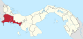
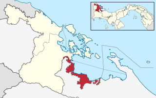
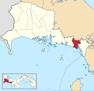
Chiriquí is a province of Panama located on the western coast; it is the second most developed province in the country, after the Panamá Province. Its capital is the city of David. It has a total area of 6,490.9 km², with a population of 462,056 as of the year 2019. The province of Chiriquí is bordered to the north by the province of Bocas del Toro, to the west by Costa Rica, to the east by the province of Veraguas, and to the south by the Pacific Ocean, specifically the Gulf of Chiriquí.

David, known as David City in colonial times, is a city and corregimiento in the west of Panama. It is the capital of the province of Chiriquí and has an estimated population of 82,907 inhabitants as confirmed in 2013. It is a relatively affluent city with a firmly established, dominant middle class and a very low unemployment and poverty index. The Pan-American Highway is a popular route to David. It is named after King David from the Bible.
Ngäbe-Buglé is the largest and most populous of Panama's five comarcas indígenas. It was created in 1997 from lands formerly belonging to the provinces of Bocas del Toro, Chiriquí, and Veraguas. The capital is known as Buäbiti in Guaymí and Llano Tugrí in Spanish.

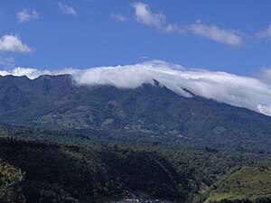
The Volcán Barú is an active stratovolcano and the tallest mountain in Panama, at 3,474 metres (11,398 ft) high. It lies about 35 km (22 mi) off the border of Costa Rica. It is also the twelfth highest peak in Central America.
Cerro Punta is a city and corregimiento in Tierras Altas District, Chiriquí Province, Panama. Cerro Punta is located in Panama's western highlands at an altitude of 6,500 feet, just south of the Continental Divide. Many of the inhabitants of the village and the surrounding areas are indigenous Native Americans. The climate, like the rest of Panama, is tropical with a short dry season and rainy season that extends about 9 – 10 months of the year. Night time temperatures are often cool due to Cerro Punta's relatively high elevation. During the 1970s much of the land was used for cultivating strawberries; households also maintained small mixed-vegetable gardens. The village can be reached by traveling north from the Pan-American highway.

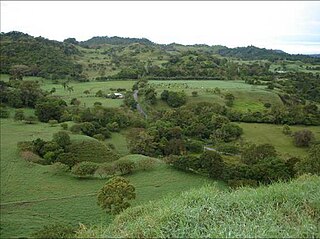
Boquete is a small mountain town in Panama. It is located in the westernmost Province of Chiriquí, about 60 kilometres (37 mi) from the border with Costa Rica, and lies on the Caldera River, in Panama's green mountain highlands. Because of its elevation, some 1,200 metres (3,900 ft) above sea level, its climate is cooler than that of the lowlands. Its scenic location, temperature, and natural environment make it popular with Panamanians and attracts tourists and retirees from all over the world.
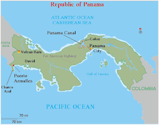
Puerto Armuelles is a city and corregimiento on Panama's Pacific coast in western Chiriquí Province adjacent to Costa Rica. It is the seat of the Barú District. Puerto Armuelles is the second-largest city in Chiriqui province with a population near 25,000 and has two different types of deep-water ports, one for bananas and one for oil.
Volcán is a town and corregimiento in Tierras Altas District, Chiriquí Province, Panama. It has a land area of 233.7 square kilometres (90.2 sq mi) and had a population of 12,717 as of 2010, giving it a population density of 54.4 inhabitants per square kilometre (141/sq mi). Its population as of 1990 was 7,146; its population as of 2000 was 10,188.
Chiriquí Grande is a district (distrito) of Bocas del Toro Province in Panama. The population according to the 2000 census was 7,431; the latest official estimate is 14,533. The district covers a total area of 210 km². The capital lies at the town of Chiriquí Grande.
Remedios District is a district (distrito) of Chiriquí Province in Panama. The population according to the 2000 census was 3,489. The district covers a total area of 168 km2. The capital lies at the city of Remedios.
The Chiriquí River is a river of Panama located at Chiriquí province at the districts of Boquete, David, Dolega, and Gualaca. Its length is 130 km. Its principal tributaries are El Platanal, David, Majagua, Cochea, Caldera, Los Valles, El Sitio, Gualaca, and Estí.
Barriles, is one of the most famous archaeological sites in Panama. It is located in the highlands of the Chiriquí Province of Western Panama at 1200 meters above sea level. It is several kilometers west of the modern town of Volcán. This places the site in the Gran Chiriquí culture area. The site was originally named for several small stone barrels found in the area, although these have also been found elsewhere in the Río Chiriquí Viejo valley and in Costa Rica. This area has a cool, spring-like climate with a pronounced rainy season between May and November, and a dry but windy season the rest of the year. The region lies on the western flanks of Volcán Barú, a dormant volcano and the highest mountain in Panama.
Health care in Panama is provided through the government and private sector businesses. The public sector is funded through the Ministry of Health (MINSA), and the Social Security Fund (CSS), which operate separate facilities. The CSS is both a health care provider and a pension fund administrator. It is funded by contributions from employers and employees. About 3.47 million people of the population of roughly 3.9 million were covered by its provisions in 2013, this included both the contributors and their dependents. MINSA provides low cost facilities for those not covered. In 2014 it operated 830 health facilities.
Alto Boquete is a corregimiento in Boquete District, Chiriquí Province, Panama. It has a land area of 89.4 square kilometres (34.5 sq mi) and had a population of 6,290 as of 2010, giving it a population density of 70.4 inhabitants per square kilometre (182/sq mi). It was created by Law 58 of July 29, 1998, owing to the Declaration of Unconstitutionality of Law 1 of 1982. Its population as of 2000 was 3,891.
Bajo Boquete is a corregimiento in Boquete District, Chiriquí Province, Panama. It is the seat of Boquete District. It has a land area of 18.2 square kilometres (7.0 sq mi) and had a population of 4,493 as of 2010, giving it a population density of 246.5 inhabitants per square kilometre (638/sq mi). Its population as of 1990 was 10,908; its population as of 2000 was 3,833.
Caldera is a corregimiento in Boquete District, Chiriquí Province, Panama. It has a land area of 147 square kilometres (57 sq mi) and had a population of 1,560 as of 2010, giving it a population density of 10.6 inhabitants per square kilometre (27/sq mi). Its population as of 1990 was 1,175; its population as of 2000 was 1,204.
Jaramillo is a corregimiento in Boquete District, Chiriquí Province, Panama. It has a land area of 77.5 square kilometres (29.9 sq mi) and had a population of 2,655 as of 2010, giving it a population density of 34.3 inhabitants per square kilometre (89/sq mi). It was created by Law 58 of July 29, 1998, owing to the Declaration of Unconstitutionality of Law 1 of 1982. Its population as of 2000 was 2,047.
Los Naranjos is a corregimiento in Boquete District, Chiriquí Province, Panama. It has a land area of 98.9 square kilometres (38.2 sq mi) and had a population of 4,596 as of 2010, giving it a population density of 46.5 inhabitants per square kilometre (120/sq mi). It was created by Law 58 of July 29, 1998, owing to the Declaration of Unconstitutionality of Law 1 of 1982. Its population as of 2000 was 4,455.
Palmira is a corregimiento in Boquete District, Chiriquí Province, Panama. It has a land area of 57.5 square kilometres (22.2 sq mi) and had a population of 1,776 as of 2010, giving it a population density of 30.9 inhabitants per square kilometre (80/sq mi). Its population as of 1990 was 2,043; its population as of 2000 was 1,513. There are three urban areas with some limited housing density. They are Palmira Centro, Palmira Arriba and Palmira Abajo. Palmira is blessed with excellent soil, abundant rivers and creeks and grows a variety of vegetables, fruits and coffee. There is also some meat production.
Ernesto Marco Aníbal Gomezjurado Solórzano better known as Marco Ernesto, was an impressionist Panamanian painter, called "The Pallete Knife Master".