Guna Yala, formerly known as San Blas, is a comarca indígena in northeast Panama. Guna Yala is home to the indigenous people known as the Gunas. Its capital is Gaigirgordub. It is bounded on the north by the Caribbean Sea, on the south by the Darién Province and Emberá-Wounaan, on the east by Colombia, and on the west by the province of Colón.
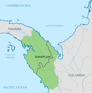
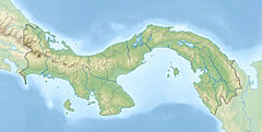
The Darién Gap is a geographic region that connects the American continents, stretching across southern Panama's Darién Province and the northern portion of Colombia's Chocó Department. Consisting of a large watershed, dense rainforest, and mountains, it is known for its remoteness, difficult terrain, and extreme environment, with a reputation as one of the most inhospitable regions in the world. Nevertheless, as the only land bridge between North and South America, the Darién Gap has historically served as a major route for both humans and wildlife.

Darién is a province in Panama whose capital city is La Palma. With an area of 11,896.5 km2 (4,593.3 sq mi), it is located at the eastern end of the country and bordered to the north by the province of Panamá and the region of Kuna Yala. To the south, it is bordered by the Pacific Ocean and Colombia. To the east, it borders Colombia; to the west, it borders the Pacific Ocean and the province of Panama.

The Guna are an indigenous people of Panama and Colombia. Guna people live in three politically autonomous comarcas or autonomous reservations in Panama, and in a few small villages in Colombia. There are also communities of Guna people in Panama City, Colón, and other cities. Most Guna live on small islands off the coast of the comarca of Guna Yala known as the San Blas Islands. The other two Guna comarcas in Panama are Kuna de Madugandí and Kuna de Wargandí. They are Guna-speaking people who once occupied the central region of what is now Panama and the neighboring San Blas Islands and still survive in marginal areas.
Darién National Park is a World Heritage Site in Panama. It is about 325 kilometers (202 mi) from Panama City, is the most extensive of all national parks of Panama, and is one of the most important World Heritage Sites in Central America.
Tacarcuna is a genus of plants in the Phyllanthaceae first described as a genus in 1989. It is native to Panama, Colombia, Venezuela, and Peru. It is apparently dioecious, with male and female flowers on separate plants.
- Tacarcuna amanoifoliaHuft - Loreto Region in Peru; Amazonas Department in Colombia
- Tacarcuna gentryiHuft - Darién Province in Panama, Magdalena Department in Colombia
- Tacarcuna tachirensisHuft - Táchira State in Venezuela
The Gulf of Darién is the southernmost region of the Caribbean Sea, located north and east of the border between Panama and Colombia. Within the gulf is the Gulf of Urabá, a small lip of sea extending southward, between Caribana Point and Cape Tiburón, Colombia, on the southern shores of which is the port city of Turbo, Colombia. The Atrato River delta extends into the Gulf of Darién.
The Kuna language, spoken by the Kuna people of Panama and Colombia, belongs to the Chibchan language family.
Rhinella acrolopha, also known as Cerro Mali beaked toad, is a species of toad in the family Bufonidae. It is found in the Serranía del Darién in eastern Panama and in the immediately adjacent northwestern Colombia, in the Los Katíos National Park. The specific name acrolopha is derived from the Greek akrolophos, meaning crest of a mountain or ridge, and refers to the isolated occurrence of this species at high elevations in the Serranía del Darién. However, the International Union for Conservation of Nature (IUCN) characterizes it as a lowland species.
Colostethus latinasus is a species of frog in the family Dendrobatidae. It is known from Cerro Pirre in Darién Province, Panama, from Chocó Department in adjacent Colombia, and from Tierralta, Córdoba Department, Colombia.
Ecnomiohyla thysanota, also known as Cerro Mali treefrog, is a species of frog in the family Hylidae. It is endemic to Panama where it is known from its type locality, Cerro Malí in eastern Serranía de Darién, near the border to Colombia, where it might also occur. This arboreal species is only known from a single specimen, the holotype.

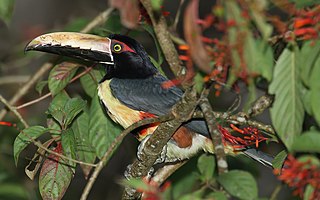
The Tacarcuna tapaculo is a species of bird in the family Rhinocryptidae. It is found in Panama and Colombia.
Capurganá is a town of the municipality of Acandí on the northwestern coast of the Gulf of Urabá in the Colombian department of Chocó, adjacent to the border between Colombia and Panama. Previously a base site for eco-tourists, since 2010 the town's main source of income has been migrants preparing to hike into Panama, across the Darién Gap. In 2019 it was described as a "smugglers' town".
The Serranía del Darién is a small mountain range on the border between Colombia and Panamá in the area called the Darién Gap. It is located in the southeastern part of the Darién Province of Panamá and the northwestern part of the Chocó Department of Colombia. There are two major protected areas here: Darién National Park in Panamá and Los Katíos National Park in Colombia. Serranía del Darién range's average elevation above sea level is 437 metres (1,434 ft). These mountains have sparse settlements, with just two people living in every square kilometer. This lack of human settlements is reflected in the fact that the nearest town with a population of 50,000 is over 12 hours by road.

The Colombia–Panama border is the 339-kilometer-long (211 mi) international boundary between Colombia and Panama. It also splits the Darién Gap, a break across the North American and South American continents. This large watershed, forest, and mountainous area is in the north-western portion of Colombia's Chocó Department and south-eastern portion of Panama's Darién Province.
Protected areas of Panama include:

The Chocó–Darién moist forests (NT0115) is a largely forested, tropical ecoregion of northwestern South America and southern Central America. The ecoregion extends from the eastern Panamanian province of Darién and the indigenous region of Guna Yala to almost the entirety of Colombia's Pacific coast, including the departments of Cauca, Chocó, Nariño and Valle del Cauca.

The Eastern Panamanian montane forests (NT0122) is an ecoregion in the east of Panama and the extreme northwest of Colombia. It contains diverse flora and fauna, with considerable endemism. The ecoregion is largely intact due to its inaccessibility, although the opening of an extension of the Pan-American Highway has introduced threats from human activity.
The Unguía Fault is an oblique dextral thrust fault in the department of Chocó in northwestern Colombia and continuing offshore Panama in the Caribbean Sea. The fault has a total length of 139.9 kilometres (86.9 mi) and is arcuate, running along a strike of 356.3 ± 30.

Ectopoglossus saxatilis is a species of frog in the family Dendrobatidae. It is known to be endemic to a small tributary of the Río Tanelita on the Colombian side of Cerro Tacarcuna, where it can be found in small streams and caves in the humid forests of the region, at around 1100 meters above sea level. Scientists suspect it may live in nearby Panama as well.