Ceunant Cynfal National Nature Reserve is a river gorge which forms part of a wet wooded ravine of the Afon Cynfal near Ffestiniog in Gwynedd, Wales. [1] The reserve is administered by Natural Resources Wales

Ceunant Cynfal National Nature Reserve is a river gorge which forms part of a wet wooded ravine of the Afon Cynfal near Ffestiniog in Gwynedd, Wales. [1] The reserve is administered by Natural Resources Wales

Llan Ffestiniog, also known as Ffestiniog or simply Llan, is a village in Gwynedd, Wales, lying south of Blaenau Ffestiniog. Llan Ffestiniog is the older of the two communities, with its church and other buildings predating most of Blaenau Ffestiniog. The population was given as 864 in the 2011 census.

The Rhinogydd are a range of mountains located east of Harlech in North Wales. The name Rhinogydd derives from the names of two of the more famous peaks, Rhinog Fawr and Rhinog Fach, although the greatest elevation in the range is reached by Y Llethr, 756 m.

Tanygrisiau is a village and area within Blaenau Ffestiniog in the upper end of the Vale of Ffestiniog in the county of Gwynedd, north-west Wales. It can be found along the southern side of the Moelwyn mountain range and dates to around 1750. It joins onto the semi-urban area of Blaenau Ffestiniog, and is in the community of Ffestiniog; located between 650 feet (200 m) and 750 feet (230 m) above sea level. it is in the electoral ward of Bowydd and Rhiw which had a 2011 census population of 1878. The village itself has a population of around 350.

The River Dwyryd (Welsh: Afon Dwyryd, meaning a river of two fords, is a river in Gwynedd, Wales which flows principally westwards; draining to the sea into Tremadog Bay, south of Porthmadog.

Foel-fras (944 m) is a mountain in the Carneddau range, about 10 km east of Bethesda in Wales. It lies on the border between the counties of Gwynedd and Conwy. With a summit elevation of 944 m it is officially the eleventh-highest summit in Wales. Foel-fras is located at the northern end of the main ridge of the Carneddau, between Drum to the north and Foel Grach to the south, with the subsidiary summit of Garnedd Uchaf (925 m) between it and Foel Grach. Due south and 400 m below lies the reservoir of Llyn Dulyn, while the smaller reservoir of Llyn Anafon lies to the north.
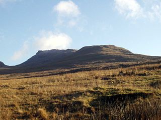
Moelwyn Bach is a mountain in Snowdonia, northern Wales and forms part of the Moelwynion. It is connected to its parent peak Moelwyn Mawr via the Craigysgafn ridge.
Moel-yr-hydd is a subsidiary summit of Moelwyn Mawr in Snowdonia, North Wales and forms part of the Moelwynion.

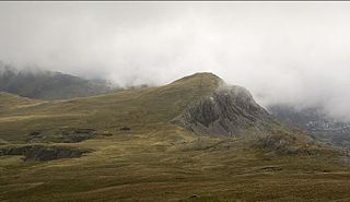
Manod Mawr is a mountain in North Wales and forms part of the Moelwynion. Although known as a mountain in the eastern Moelwyns, it and its sister peaks are sometimes known as the Ffestiniog hills.

The Afon Lledr is a river in north-west Wales and the second major tributary of the River Conwy. It is about 10 miles or 16 km long, and flows in a generally easterly direction.

Afon Dulyn is the outflow from Llyn Dulyn, a lake in the Carneddau mountains in north-west Wales. It is a tributary of the river Conwy.

The Migneint is a large expanse of moorland in central Snowdonia, north-west Wales. It is part of the Migneint-Arenig-Dduallt Special Area of Conservation, along with the mountains Arenig Fawr, Arenig Fach and Dduallt, covering a range of nearly 200 square kilometres (77 sq mi). It is either the largest area of blanket bog in Wales, or the second largest, after the Berwyn range, further to the east.

The Welsh Highland Heritage Railway is a short reconstructed heritage railway in Gwynedd, Wales. Its main station is in Porthmadog.


Coed Camlyn National Nature Reserve is a nature reserve located south of the village of Maentwrog in Gwynedd, Wales.
Coedydd Maentwrog, on the north side of the Vale of Ffestiniog, is the largest wood in the Vale. The national nature reserve consists of two separate sections: Coed Llyn Mair, and a group of three forests. It offers a variety of habitats, rising from the wooded valley onto open moorland and reaching towards the foot of Moelwyn Bach mountain. A nature trail and a network of public footpaths are features of the reserve. Animals such as the rare lesser horseshoe bat and the wood warbler can be spotted here, and the gorge is noted for its liverworts and lichens.
The A496 is a major coastal and mountainous road in southern Snowdonia.

Blaenau Ffestiniog Amateur Football Club are a Welsh football club from Blaenau Ffestiniog, Gwynedd. They play in the North Wales Coast East Football League Premier Division, which is in the fourth tier of the Welsh football league system. Founded in 1883, they are given the nickname "The Quarrymen" due to the quarry history around the town.
Llech Ronw, or the Slate of Gronw, is a holed stone located along Afon Bryn Saeth in Blaenau Ffestiniog, Wales. The stone is described as being roughly forty inches by thirty inches with a hole of about an inch in diameter going through it.
Coed Cymerau National Nature Reserve is a wooded area of approximately 26 hectares on the north side of the Vale of Ffestiniog through which the River Goedol runs. There is one path that runs through the forest but the rest of the area is primarily native broadleaved woodland and thick undergrowth, adjacent to the nature reserve is Coed Cymerau Isaf which is owned by the Woodland Trust.
52°56′56″N3°56′38″W / 52.949°N 3.944°W
| | This article about a location in Wales is a stub. You can help Wikipedia by expanding it. |