
Karst is a topography formed from the dissolution of soluble carbonate rocks such as limestone, dolomite, and gypsum. It is characterized by features like poljes above and drainage systems with sinkholes and caves underground. It has also been documented for more weathering-resistant rocks, such as quartzite, given the right conditions.

Llandeilo is a town and community in Carmarthenshire, Wales, situated at the crossing of the River Towy by the A483 on a 19th-century stone bridge. Its population was 1,795 at the 2011 Census. It is adjacent to the westernmost point of the Brecon Beacons National Park. The town is served by Llandeilo railway station on the Heart of Wales Line.

Whitbarrow is a hill in Cumbria, England. Designated a biological Site of Special Scientific Interest and national nature reserve, it forms part of the Morecambe Bay Pavements Special Area of Conservation due to its supporting some of the best European examples of natural limestone habitats. Also known as Whitbarrow Scar, the hill lies about 9 kilometres (5.6 mi) south-west of Kendal, just north of the A590 road, close to the village of Witherslack. Part of the site is a local nature reserve called Whitbarrow Scar.

Ebbor Gorge is a limestone gorge in Somerset, England, designated and notified in 1952 as a 63.5-hectare (157-acre) biological Site of Special Scientific Interest in the Mendip Hills. It was donated to the National Trust in 1967 and is now managed by Natural England as a national nature reserve.

A turlough is a seasonal or periodic water body found mostly in limestone karst areas of Ireland, west of the River Shannon. The name comes from the Irish tur, meaning "dry", and loch, meaning "lake". The water bodies fill and empty with the changes in the level of the water table, usually being very low or empty during summer and autumn and full in the winter. As groundwater levels drop the water drains away underground through cracks in the karstic limestone.

Carboniferous Limestone is a collective term for the succession of limestones occurring widely throughout Great Britain and Ireland that were deposited during the Dinantian Epoch of the Carboniferous Period. These rocks formed between 363 and 325 million years ago. Within England and Wales, the entire limestone succession, which includes subordinate mudstones and some thin sandstones, is known as the Carboniferous Limestone Supergroup.
Cheddar Wood is an 86.9-hectare (215-acre) biological Site of Special Scientific Interest at Cheddar in the Mendip Hills, Somerset, England, notified in 1967.

Midger is a 65.7-hectare (162-acre) biological Site of Special Scientific Interest straddling the border of Gloucestershire and South Gloucestershire, notified in 1966 and renotified in 1984. Since the last revision in 1974, the size has been reduced to a 56-hectare (140-acre) site. It lies east of Hillesley, Gloucestershire and north of Hawkesbury Upton, South Gloucestershire. It is at the head of the Kilcott Valley.

The Wye Valley Area of Outstanding Natural Beauty is an internationally important protected landscape straddling the border between England and Wales.

The geology of Wales is complex and varied; its study has been of considerable historical significance in the development of geology as a science. All geological periods from the Cryogenian to the Jurassic are represented at outcrop, whilst younger sedimentary rocks occur beneath the seas immediately off the Welsh coast. The effects of two mountain-building episodes have left their mark in the faulting and folding of much of the Palaeozoic rock sequence. Superficial deposits and landforms created during the present Quaternary period by water and ice are also plentiful and contribute to a remarkably diverse landscape of mountains, hills and coastal plains.

Hampton is an interim Australian bioregion located in southeastern coastal Western Australia, with a small portion (4%) extending into adjacent South Australia. It has an area of 1,088,198 hectares. The Hampton bioregion is part of the Coolgardie woodlands ecoregion.

Leck Fell is a Site of Special Scientific Interest in Lancashire, England. An area of typically heavily grazed open moorland of rough grass and remnant patches of heather with little or no tree cover, it is characterised by the virtual absence of surface drainage and an extensive subterranean drainage network resulting in cave systems and numerous sinkholes. It surrounds the high point of Gragareth 627 metres (2,057 ft) between Leck Beck and Kingsdale.
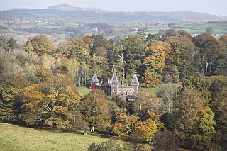
Dinefwr Park National Nature Reserve is an 800 acres (320 ha) estate about a mile from the centre of Llandeilo in Carmarthenshire owned by the National Trust, with a mansion in the centre. The highest point is occupied by the ruined Dinefwr Castle, ancient castle of the Deheubarth kingdom. It is a grade I Historic Park and a Site of Special Scientific Interest.
Carmel is a village in Carmarthenshire, Wales near the village of Cross Hands.

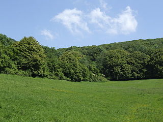
Cernydd Carmel is a Site of Special Scientific Interest in Carmarthenshire, Wales.
Lower Wye Gorge is a 65-hectare (160-acre) biological and geological Site of Special Scientific Interest in Gloucestershire, notified in 1954 and renotified 1987. The site includes two Gloucestershire Wildlife Trust nature reserves being Ban-y-gor Wood and Lancaut. The Natural England citation states a revision for Lancaut inclusion.
Shorn Cliff And Caswell Woods is a 69.2-hectare (171-acre) biological Site of Special Scientific Interest in Gloucestershire, notified in 1986. The site is listed in the 'Forest of Dean Local Plan Review' as a Key Wildlife Site (KWS).
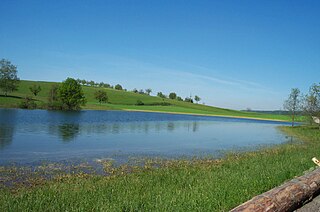
Karst lakes are formed as the result of a collapse of caves, especially in water-soluble rocks such as limestone, gypsum and dolomite. This process is known as karstification. They can cover areas of several hundred square kilometres. Their shallow lakebed is usually an insoluble layer of sediment so that water is impounded, leading to the formation of lakes. Many karst lakes only exist periodically, but return regularly after heavy rainfall.
This article describes the geology of the Brecon Beacons National Park in mid/south Wales. The area gained national park status in 1957 with the designated area of 1,344 km2 (519 sq mi) including mountain massifs to both the east and west of the Brecon Beacons proper. The geology of the national park consists of a thick succession of sedimentary rocks laid down from the late Ordovician through the Silurian and Devonian to the late Carboniferous period. The rock sequence most closely associated with the park is the Old Red Sandstone from which most of its mountains are formed. The older parts of the succession, in the northwest, were folded and faulted during the Caledonian orogeny. Further faulting and folding, particularly in the south of the park is associated with the Variscan orogeny.
The bedrock geology of Carmarthenshire in west Wales consists largely of Palaeozoic age sedimentary rocks. Unconsolidated deposits of Quaternary age in Carmarthenshire include a dissected cover of glacial till, valley floor alluvium and some scattered peat deposits in both upland and lowland settings. There are extensive beach and tidal flat deposits along the Carmarthenshire coast. The exploitation of the county's mineral riches, particularly coal and limestone, was a key part of the local economy through much of the nineteenth and twentieth centuries.
