The reserve covers 437 hectares (1,080 acres) of the Caldicot Level, a low-lying area of land bordering the northern shore of the Severn Estuary. Part of the site is a reclaimed fuel ash disposal site, although some farmland in Goldcliff and Nash has also had to be flooded to complete the work.
In January 2024 the reserve was the focus for the BBC programme Countryfile.[3]
Access and facilities
Map of Newport Wetlands RSPB Reserve
Entrance is free, with car parking facilities open every day of the year from 9:00 am until 5:00 pm. The visitor and education centre are open every day except Christmas Day.[4] The visitor centre provides a shop, refreshments, bathroom facilities, viewing facilities and guided tours. Dogs and cyclists are permitted outside the visitor centre and along a specially marked six-kilometre (3.7mi) circular route around the reserve's perimeter which is accessed via a path next to the car park exit. Initially heading west, the route runs alongside the power station then turns to the east past the East Usk Lighthouse and along the Severn Estuary (Wales Coast Path). After dropping below the sea wall, the path splits, with a pedestrian and dog walking route returning to the visitor centre via a marked path to the left. A longer pedestrian and cycling route continues towards Goldcliff village and the local road network.
Next to the visitor centre is a picnic and play area, which provides a children's play area, education zone, and benches for picnics.
The far end of the main trail faces south towards the Severn Estuary, along which the East Usk Lighthouse and a bird hide overlooking lagoon R9 are situated. There is also a woodland trail, which is entered by turning left at the top of the hill. The trail passes neighbouring farmland, through the reserve's woodlands, past a lagoon viewing platform which overlooks lagoon R8, and onto the estuary trail.
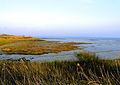
View of Severn Estuary Rocks From Newport Wetlands RSPB Reserve
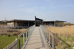
Newport Wetlands RSPB Reserve visitor centre as seen from picnic and play area
Visitor centre and picnic and play area seen from hill
The reserve contains an artificial floating walkway, which provides a direct route to the lighthouse over lagoon R7. This lagoon is one of three lagoons spanning the coastal path (east to west). The most easterly lagoon (R9) is overlooked by a bird hide in addition to being viewable from a fenced overpass, and the most westerly lagoon (R4) is viewable from a fenced overpass.
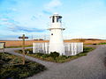
East Usk Lighthouse
Lighthouse
East Usk Lighthouse
East Usk lighthouse, near Perry Lane, West Nash, Newport
The East Usk Lighthouse is within the reserve on the estuary trail facing towards the Severn Estuary. It is a basic lamphousing with no accommodation. The more substantial decommissioned West Usk Lighthouse, currently operating as a hotel, is on the opposite (west) bank of the River Usk and can be viewed from the reserve. It was constructed in 1893 by Trinity House and entered service on or about 22 June that year.[10]
East Usk Lighthouse at Newport Wetlands RSPB Nature Reserve facing east towards bird hide
This page is based on this Wikipedia article Text is available under the CC BY-SA 4.0 license; additional terms may apply. Images, videos and audio are available under their respective licenses.