
Chearoco, Chiaraco or Chiaroco is a mountain in the Cordillera Real in the Andes of Bolivia. It has a height of about 6,127 m (20,102 ft). It is situated in the La Paz Department, Larecaja Province, Guanay Municipality, southeast of the peak of Aman Pata. Chearoco lies between Qalsata in the northwest and Chachakumani in the southeast.

The Ch'iyar Juqhu River is a Bolivian river east of Lake Titicaca in the La Paz Department. It originates in the Cordillera Real near the peaks of the 6,127 m high Ch'iyar Juqhu which is probably named after the river or the region around it and the 5,871 m high Qalsata and flows down towards the Altiplano.
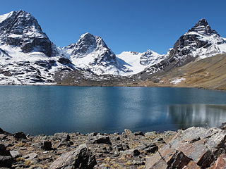
Ch'iyar Quta is a lake in the Cordillera Real of Bolivia situated in the La Paz Department, Los Andes Province, Pucarani Municipality, Huayna Potosí Canton. It is situated at a height of about 4,700 metres (15,400 ft)near the peaks of Kunturiri and east of the lake Juri Quta.
Ch'iyar Quta may refer to:

Ch'iyar Quta is a small Bolivian lake located in the Sajama Province of the Oruro Department near the border to Chile. It is situated at a height of about 5,090 meters inside the boundaries of the Sajama National Park. Ch'iyar Quta lies south-east of the peaks of Laram Q'awa, Milluni and Kunturiri, south-west of Jisk'a Kunturiri and north of Patilla Pata.

Ch'iyar Qullu is a 4,778-metre-high (15,676 ft) mountain in the western extension of the Cordillera Real in the Andes of Bolivia. It is situated in the La Paz Department, Los Andes Province, Pucarani Municipality. Ch'iyar Qullu lies southwest of Tuni Lake, between the rivers Kunturiri in the north and Tuni in the south.
Ch'iyar Qullu is a 4,875-metre-high (15,994 ft) mountain in the north of the Cordillera Real in the Andes of Bolivia. It is situated in the La Paz Department, Larecaja Province, Sorata Municipality. Ch'iyar Qullu lies west of the Janq'u Uma-Illampu massif and north-east of the mountain Achachi Qullu (Achachi Kkollu).
Achuma is a mountain in the northern part of the Kimsa Cruz mountain range in the Bolivian Andes, about 4,960 metres (16,273 ft) high. It is situated in the La Paz Department, Loayza Province, Cairoma Municipality. The peaks of Achuma lie north-west to north of the mountain Taruja Umaña and south of Janq'u Willk'i. There are two small lakes north of the mountain. They are named Allqa Quta and Ch'iyar Quta.
Janq'u Willk'i is a mountain in the northern part of the Kimsa Cruz mountain range in the Bolivian Andes, about 4,800 metres (15,748 ft) high. It is situated in the La Paz Department, Loayza Province, Cairoma Municipality. Janq'u Willk'i lies north of the mountains Taruja Umaña and Achuma. There are two small lakes at the feet of Achuma and Janq'u Willk'i. They are named Allqa Quta and Ch'iyar Quta.
Ch'iyar Qullu is a 4,688-metre-high (15,381 ft) mountain in the Bolivian Andes. It lies in the La Paz Department, Murillo Province, Palca Municipality. Ch'iyar Qullu is situated north-east of the mountain Achachi Qala.
Tata Ch'iyar Qullu or just Ch'iyar Qullu(Charkkollu) is a mountain in the Bolivian Andes, about 4,800 metres (15,748 ft) high. It lies in the La Paz Department, Murillo Province, Palca Municipality. Ch'iyar Qullu is situated near the river Chuqi Quta, south-west of the lake Ch'uxña Quta and north-west of the village of Chuqi Quta (Choquecota, Choquekhota).
Ch'uxña Quta is a lake in the La Paz Department in Bolivia. It is situated in the Murillo Province, Palca Municipality. Ch'uxña Quta lies northeast of the mountain Tata Ch'iyar Qullu.
Laram Quta is a lake in the Cordillera Real in the Andes of Bolivia. It is located in the La Paz Department, Sud Yungas Province, Irupana Municipality. It lies south of the mountain Mururata. Laram Quta is situated south-west of the lakes Artisa Pata (Arteza Pata) and Artisa Quta (Arteza Kkota). The lakes north-west of it are named Qillwa Quta and Ch'iyar Quta which is the small one next to Laram Quta.
Jach'a Jawira which later is named Q'ara Qullu and Waña Jawira is a Bolivian river in the La Paz Department and in the Oruro Department. Its waters flow towards Uru Uru Lake.
Jisk'a Chukita is a mountain in the Cordillera Real in the Bolivian Andes, about 4,980 m (16,339 ft) high. It is situated in the La Paz Department, Murillo Province, La Paz Municipality. Jisk'a Chukita lies northwest of Jach'a Chukita and southeast of Kunturiri. Ch'iyar Quta Jawira flows along its northern slopes.
Qutani is a mountain in the Bolivian Andes which reaches a height of approximately 3,740 m (12,270 ft). It is located in the La Paz Department, Loayza Province, Luribay Municipality, northwest of Luribay. Qutani lies southeast of Wila Quta.
Wila Quta is a mountain in the Bolivian Andes which reaches a height of approximately 4,100 m (13,500 ft). It is located in the La Paz Department, Loayza Province, Sapahaqui Municipality, at the border with the Luribay Municipality. Wila Quta lies northwest of Qutani.
Jach'a Ch'uñu Uma is a mountain in the Bolivian Andes which reaches a height of approximately 3,960 m (12,990 ft). It is located in the La Paz Department, Loayza Province, Luribay Municipality. Jach'a Ch'uñu Uma lies north of a river named Ch'uñu Uma.
Janq'u Qala is a mountain in the Bolivian Andes which reaches a height of approximately 3,900 m (12,800 ft). It is located in the La Paz Department, Loayza Province, Luribay Municipality. Janq'u Qala lies southeast of Jach'a Ch'uñu Uma and Mula Jalanta.
Ch'api Qullu is a 3,478-metre-high (11,411 ft) mountain in the Bolivian Andes. It is located in the La Paz Department, Loayza Province, Luribay Municipality. Ch'api Qullu lies northeast of Jach'a Ch'uñu Uma.


