
Canoe Township is a township in Indiana County, Pennsylvania, United States. The population was 1,432 at the 2020 census, a decline from the figure of 1,505 tabulated in 2010. Canoe Township was formed from Montgomery Township in 1847. It was named after Canoe Creek, which was so called because its mouth on Mahoning Creek was traditionally the head of canoe navigation. The township includes the communities of Canoe Ridge, Juneau, Locust, Locust Lane, Robertsville, and Rossiter.

Kachhi District or Kacchi, known until 2008 as Bolan District, is a district in central Balochistan, Pakistan. The Bolan area remained under one district Kacchi until 31 December 1991. The Deputy Commissioner's office started functioning on 17 May 1992, and Bolan became one of the four districts of Naseerabad Division, until the abolition of Divisions in 2000.

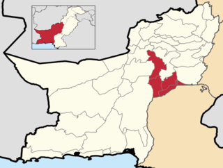
Jhal Magsi District is a district in central Balochistan in Pakistan. Previously part of Kachhi District, it was established as a district of its own in December 1991 and after a brief period in which it was known as Kachhi, its name was changed to Jhal Magsi in May 1992. The district is named after the town of Jhal, seat of the Magsi tribe, the major tribes within the district are Magsi, Lashari and jamote. Historically, the Magsi tribe is Samma tribe.

Sibi is a district in the Balochistan province of Pakistan. The main mountain ranges are Zen, Bambore and Dungan. The climatic and topography of Sibi District is quite varied compared to other districts of Balochistan. It is also known as the "Hot spot" of Pakistan where the temperatures in the summer exceed 52.6 °C (126.7 °F). Until 2013 the district had two sub-divisions, Sibi and Lehri, further organized into Tehsils and sub-tehsils: Sibi, Lehri, Kutmandi and Sangan. Lehri was rejoined with Sibi district in 2018.
Nasirabad Division is an administrative division of Balochistan Province, Pakistan. It is the only Irrigation & Agricultural Division of Balochistan, The division connects Balochistan with Sindh. Nasirabad division created by bifurcation of Sibi division in 1987. Its Divisional headquarters are at Dera Murad Jamali.

Machh, or Mach, is a town and union council of Kachhi District in the Balochistan province of Pakistan. The town has an altitude of 1006 metres and is located at 29°52'0N 67°19'60E, - some about 50 km southeast of Quetta, the provincial capital.
Malkot is a village of Abbottabad District in Khyber-Pakhtunkhwa province of Pakistan. Until the local government reforms of 2000 it was a Union Councils of the district.
Ghora Gali is one of the tourist mountain resort towns of the Galyat area of northern Pakistan. It has an elevation of 1691m and is located in the northeastern tip of the Punjab province of Pakistan. Ghora Gali is also a Union council, an administrative subdivision, of Murree Tehsil in Murree District and is located at 33.83°N 73.35°E. According to the 1998 census of Pakistan it had a population of 14410.
Chak Malook is a village and union council, an administrative subdivision, of Chakwal District in the Punjab Province of Pakistan, it is part of Chakwal Tehsil, and is located at 32°58'0N 72°57'0E.
Darya Gali is a village and union council of Murree Tehsil in the Murree District of Punjab, Pakistan. It is located in the north of the tehsil and is bounded to the north by Khyber-Pakhtunkhwa, to the south by Ghora Gali and Murree, and to the west by Rawat.
Potha Sharif is a village and union council of Murree Tehsil in the Murree District of Punjab, Pakistan. It is located in the north-east of the tehsil at 33°57'0N 73°30'0E, and is bounded to the north by Phagwari, to the south by Sehr Bagla, to the west by Rawat and to the east by Kashmir. The village contains the mazar of the Sufi saint Hazarat Dada Malik Suraj Abbasi, forefather of the Potha Shareef people. He had seven sons and their descendants are currently present in Potha Shareef. People visit the mazar from different areas of the country to offer tribute.
Loti is town and union council of Dera Bugti District in the Balochistan province of Pakistan. It is located at 28°56'60N 69°24'0E, and has an altitude of 466 metres, the area is rich in natural resources.
Jalal Khan is town and union council of the Kachhi District in the Balochistan province of Pakistan. It is located at 29°2'0"N 67°44'0"E and has an altitude of 89 metres (295 feet).

Gharmala is a village located in Jhelum District, Punjab, Pakistan. It is part of Jhelum Tehsil. and lies along Rohtas Road. The village is about 3 km west of Jhelum and has a population of over 5,000. It has girls' and boys' high schools. Two mosques are there.
Nachindi is a village in the Punjab province of Pakistan. It is part of the Union Council of Jand Khanzada in Chakwal Tehsil. The population of Nachindi is about 4249. A large percentage of the population works for the Pakistan Army and other defence-related departments.
Wan Radha Ram is a town and Union Council of Kasur District in the Punjab province of Pakistan. It is part of Pattoki Tehsil and is located at 30°56'60N 73°45'0E with an altitude of 181 metres (597 feet).
Mianwal Ranjha is a village and union council of Mandi Bahauddin District in the Punjab province of Pakistan. It is located at 31°52'60N 73°5'60E and has an altitude of 183 metres. Mianwal Ranjha is the largest village of Mandi Bahauddin.
Monan is a village and union council of Jhelum District in the Punjab Province of Pakistan. It is part of Jhelum Tehsil, and is located at 32°57′0″N73°41′0″E and has an altitude of 229 metres (754 feet).
Dhadar, also spelt Dadhar, is the capital of the Kachhi District in the Balochistan province of Pakistan. The town which also consists of one Union Council is the headquarters of the tehsil of the same name. It is located at 29°28'0"N 67°39'0"E and has an altitude of 132 metres (436 feet).
Mehram is town and union council of Kachi District in the Balochistan province of Pakistan. It is located at 28°51'0N 67°49'0E and has an altitude of 67 metres.
