
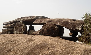
Srikakulam is a city and the headquarters of Srikakulam district in the Indian state of Andhra Pradesh. As of 2011 census, it has a population of 165,735. There are many other places of Buddhist Tourism such as Salihundam, Kalinga Patnam, Dabbaka Vaani Peta, Nagari Peta, Jagati Metta, Singupuram etc. in Srikakulam District. The Buddhist heritage site of Salihundam has some unique features. It has a beautiful star atop a stupa, rock cut massive stupas inside chaitya grihas, brick stupas with wheel pattern plan, votive stupas, inscriptions on the steps leading to the stupas and museum housing over two dozen sculpted statue and figurines of Buddha, Jain Teerthankars and other deities

Vizianagaram district is one of the six districts in the Uttarandhra region of the Indian state of Andhra Pradesh with its headquarters located at Vizianagaram. The district was once the part of ancient Kalinga.Saripilli Dibbilingeswara temple, Jayathi Mallikarjuna Temple are the finest examples of ancient Eastern Ganga Dynasty built monuments in the district. The district is bounded on the east by the district of Srikakulam, north by Parvathipuram Manyam south by Visakhapatnam, Anakapalli, southeast by the Bay of Bengal, and west by Alluri Sitharama Raju district. It was formed on 1 June 1979, with some parts carved from the neighbouring districts of Srikakulam and Visakhapatnam. The district is named after the princely state of Vizianagaram. In 2011, it was the least populous district in Andhra Pradesh.

Srikakulam district is one of the twenty-six districts of the Indian state of Andhra Pradesh, located in the Uttarandhra region of the state, with its headquarters located at Srikakulam. It is one of the six districts, located in the extreme northeastern direction of the state. It was formerly known as Chicacole, and was under Ganjam district till 1936 April 1, then merged under Vizagapatam district. Srikakulam district forms the core area of Kalinga where most of its historical capitals like Kalinganagari, pithunda, Dantapuram are located.

Visakhapatnam district is one of the six districts in the Uttarandhra region of the Indian state of Andhra Pradesh, headquartered at Visakhapatnam. It is one of the twenty-six districts in Andhra Pradesh state. The district shares borders within the north and east, Vizianagaram district and South Anakapalli district in the south-west and Bay of Bengal in the south.

Arasavalli is an outgrowth of Srikakulam municipality in Srikakulam district of the Indian state of Andhra Pradesh. It is located in Srikakulam mandal of Srikakulam revenue division. It is situated at a distance of about 1.6 km. from Srikakulam, the district headquarters and 17 km. from Srikakulam road, the railway station on Visakhapatnam-Howrah Line.
Amadalavalasa is a town in Srikakulam district of the Indian state of Andhra Pradesh. It is a municipality and also the mandal headquarters of Amadalavalasa mandal. The town is spread over an area of 19.65 km2 (7.59 sq mi), which is under the jurisdiction of Visakhapatnam Metropolitan Region Development Authority. Srikakulam Road railway station is situated at Amadalavalasa.

Ichchapuram is a town in the Srikakulam district of the Indian state of Andhra Pradesh. The town is located nearly 142 km from the district capital, Srikakulam. It is located on the border of Odisha and Andhra Pradesh. Ichchapuram municipality is the largest urban local body in the Srikakulam district. It had a population of 36,493 as of 2011.
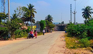
Ranastalam is a village adjoining National Highway 16 in Srikakulam district of the Indian state of Andhra Pradesh. There are nearly 55 villages in Ranastalam mandal.Jrpuram kon damulagam kosta pydibheemavaram kammasigadam etc.
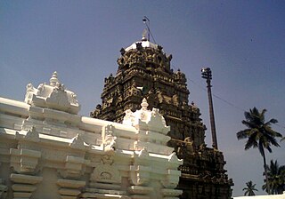
Sri Kurmam also known as Srikurmu or Srikurmais a village near Srikakulam, Andhra Pradesh, India. Srikurmam village is situated at a distance of 14.5 km to the South-east of Srikakulam town. It is in the Gara mandal of Srikakulam district. The village was named after the Srikurmam temple dedicated to Kurma avatar of the Hindu god Vishnu, which was re-established by Eastern Ganga Dynasty King Anantavarman Chodaganga Deva.

Sangam is a village and a pilgrimage site in Vangara mandal in Srikakulam district in the state of Andhra Pradesh, India. Sangam is a village and a pilgrimage site in Vangara mandal in Srikakulam district in the state of Andhra Pradesh, India.
Kotabommali is a mandal in the Srikakulam district of the Indian state of Andhra Pradesh.
Laveru is a village in Srikakulam district of the Indian state of Andhra Pradesh. Laveru is located on Subhadrapuram-Cheepurupalli road that connects National Highway-5 to Cheepurupalli railway station on Howrah-Chennai mainline. The village is located in Pedda Gedda river basin.

Narasannapeta is a census town in Srikakulam district of the Indian state of Andhra Pradesh. It is the mandal headquarters of Narasannapeta mandal in Srikakulam revenue division. 43 villages are there under the administrative division of Narasannapeta.

Pathapatnam is a town in Srikakulam district of the Indian state of Andhra Pradesh. It is located in Pathapatnam mandal of Palakonda revenue division. Pathapatnam is located on the border of Srikakulam district of Andhra Pradesh and Gajapati district of Odisha. Parlakhemundi, the headquarters of Gajapati District, can be considered as twin town of Pathapatnam because of its close proximity. It is located around 65 km from srikakulam. It was the old capital of Paralakhemundi Gajapati Maharajah of his erstwhile kingdom.
Saravakota is a village in Srikakulam district of the Indian state of Andhra Pradesh. It is located in Saravakota mandal of Palakonda revenue division.
Sarubujjili is a village in Srikakulam district of the Indian state of Andhra Pradesh. Sarubujjili mandal is bordered by Burja, Seethampeta, Hiramandalam, Jalumuru and Narasannapeta mandals of Srikakulam district.

Tekkali is a census town in Srikakulam district of the Indian state of Andhra Pradesh. It is the mandal headquarters of Tekkali mandal and Tekkali revenue division and is located at a distance of 51 km from the district headquarters.
Anandapuram is a suburb and a mandal of Visakhapatnam district in the state of Andhra Pradesh, India.
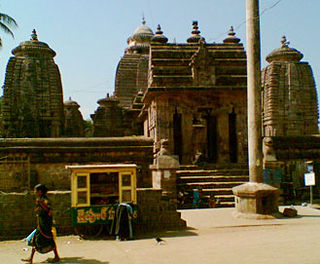
Mukhalingam, also known as Srimukhalingam or Mukhalinga, is a village panchayat in Jalumuru mandal of Srikakulam district in the Indian state of Andhra Pradesh. Historically known as Kalinganagari, Mukhalingam served as the capital of Eastern Ganga Dynasty from 6th century AD to 12th century AD. Emperor Sri Ananthavarma Chodaganga Devara conquered Utkala in 1122 AD and shifted the capital from Kalinganagari to Caudwara kataka
Jarjangi is a Panchayath village in Kotabommali mandal, Srikakulam district, in the Indian state of Andhra Pradesh. The Postal Index Code of this village is 532195.


