
The Territory of Ashmore and Cartier Islands is an uninhabited external territory of Australia consisting of four low-lying tropical islands in two separate reefs, and the 12-nautical-mile territorial sea generated by the islands. The territory is located in the Indian Ocean situated on the edge of the continental shelf, about 320 km (199 mi) off the northwest coast of Australia and 144 km (89 mi) south of the Indonesian island of Rote.
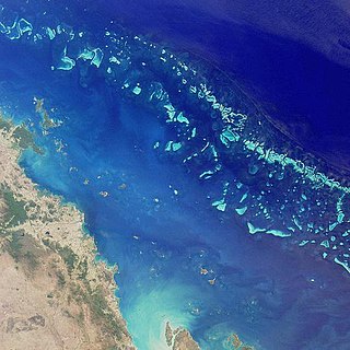
The Great Barrier Reef is the world's largest coral reef system composed of over 2,900 individual reefs and 900 islands stretching for over 2,300 kilometres (1,400 mi) over an area of approximately 344,400 square kilometres (133,000 sq mi). The reef is located in the Coral Sea, off the coast of Queensland, Australia, separated from the coast by a channel 100 miles wide in places and over 200 feet deep. The Great Barrier Reef can be seen from outer space and is the world's biggest single structure made by living organisms. This reef structure is composed of and built by billions of tiny organisms, known as coral polyps. It supports a wide diversity of life and was selected as a World Heritage Site in 1981. CNN labelled it one of the seven natural wonders of the world in 1997. Australian World Heritage places included it in its list in 2007. The Queensland National Trust named it a state icon of Queensland in 2006.

Dhilba Guuranda–Innes National Park, formerly Innes National Park, is an IUCN-designated protected area in the Australian state of South Australia located on the southwest tip of Yorke Peninsula about 300 kilometres (190 mi) west of the state capital of Adelaide. It is a popular destination for camping, bushwalking, fishing, surfing and scuba diving.
A marine park is a designated park consisting of an area of sea set aside to achieve ecological sustainability, promote marine awareness and understanding, enable marine recreational activities, and provide benefits for Indigenous peoples and coastal communities. Most marine parks are managed by national governments, and organized like 'watery' national parks, whereas marine protected areas and marine nature reserves are often managed by a subnational entity or non-governmental organization, such as conservation authority.

The Buccaneer Archipelago is a group of islands off the coast of Western Australia near the town of Derby in the Kimberley region. The closest inhabited place is Bardi located about 54 kilometres (34 mi) from the western end of the island group.

The Ningaloo Coast is a World Heritage Site located in the north west coastal region of Western Australia. The 705,015-hectare (1,742,130-acre) heritage-listed area is located approximately 1,200 kilometres (750 mi) north of Perth, along the East Indian Ocean. The distinctive Ningaloo Reef that fringes the Ningaloo Coast is 260 kilometres (160 mi) long and is Australia's largest fringing coral reef and the only large reef positioned very close to a landmass. The Muiron Islands and Cape Farquhar are within this coastal zone.

The Horizontal Falls, or Horizontal Waterfalls, nicknamed the "Horries" and known as Garaanngaddim to the local Indigenous people, are an unusual natural phenomenon on the coast of the Kimberley region in Western Australia, where tidal flows cause waterfalls on the ebb and flow of each tide. The Lalang-garram / Horizontal Falls Marine Park is a protected area covering the falls and wider area.

Camden Sound is a relatively wide body of water in the Indian Ocean located in the Kimberley region of Western Australia. The Sound is bounded by the Bonaparte Archipelago to the north-east, the Buccaneer Archipelago to the south-west, and Montgomery Reef to the south.
Bigge Island is an island off the coast of the Kimberley region in Western Australia, within the Shire of Wyndham-East Kimberley.
Montgomery Reef is a reef off the Kimberley coast of Western Australia. It is situated at the south western end of Camden Sound and surrounds Yawajaba (Montgomery) Island. With its total area of 400 square kilometres (154 sq mi), it is the world's largest inshore reef. The nearest populated place is Bardi, which is approximately 130 kilometres (81 mi) to the south west.
Yawajaba Island, often referred to as Montgomery Island is an island off the Kimberley coast of Western Australia.
There are over 2,500 islands lying off the coast of the Kimberley region of Western Australia.
Browse Island is a small, approximately 14-hectare (35-acre), uninhabited island lying in the Timor Sea about 180 kilometres (110 mi) north-west of the Kimberley coast of north-western Australia. It is a Western Australian Nature Reserve that is classed as 'Not Class A' vested with the state Conservation Commission and managed by the Department of Environment and Conservation. It is considered Western Australia's most remote island, and is also one of the most remote Australian islands to not fall under external territory status.
Coronation Island, also known as Garlinju, is located off the Kimberley coast of Western Australia. It encompasses an area of 3,817 hectares. It is located off Port Nelson in the Bonaparte Archipelago, as a part of the group of islands known as the Coronation Islands, which were named by Philip Parker King, the first European to visit the islands in 1820, after the anniversary of the coronation of George III, who had died in January of that year.
Molema Island is an island off the Kimberley coast of Western Australia.

The Worrorra, also written Worora, are an Aboriginal Australian people of the Kimberley area of north-western Australia.
The Yawijibaya, also written Jaudjibaia, are an Aboriginal Australian people of the Kimberley region of northern Western Australia. Along with the Unggarranggu people, they are the traditional owners of Buccaneer Archipelago, off Derby, together known as the Mayala group for native title purposes. Yawijibaya country includes Montgomery Island (Yawajaba) and the surrounding Montgomery Reef.
The Kimberley Marine Park, formerly known as the Kimberley Commonwealth Marine Reserve and also known as the Great Kimberley Marine Park, is an Australian marine park offshore of Western Australia, near the Kimberley region. Proclaimed under the EPBC Act in 2013, the marine park covers an area of 74,469 km2 (28,753 sq mi) and is assigned IUCN category VI. It is one of the 13 parks managed under the North-west Marine Parks Network. It covers a number of state-managed marine parks.
The Ashmore Reef Marine Park is an Australian marine park that covers the Ashmore Reef, which is located about 630 km (390 mi) north of Broome and 110 km (68 mi) south of the Indonesian island of Rote. The marine park covers an area of 583 km2 (225 sq mi) and is assigned IUCN category Ia. It is one of 13 parks managed under the North-west Marine Parks Network.
The North Kimberley Marine Park is the largest state-managed marine park in Western Australia and second largest in Australia. covering 1,845,000 ha or 18,450 km2 (7,120 sq mi) about 270 km (170 mi) north-east of Derby. It is located in the Indian Ocean and the Timor Sea, extending from York Sound north-eastwards to the WA border with the Northern Territory.
