Related Research Articles

HMS Beagle was a Cherokee-class 10-gun brig-sloop of the Royal Navy, one of more than 100 ships of this class. The vessel, constructed at a cost of £7,803, was launched on 11 May 1820 from the Woolwich Dockyard on the River Thames. Later reports say the ship took part in celebrations of the coronation of King George IV of the United Kingdom, passing through the old London Bridge, and was the first rigged man-of-war afloat upriver of the bridge. There was no immediate need for Beagle so she "lay in ordinary", moored afloat but without masts or rigging. She was then adapted as a survey barque and took part in three survey expeditions.

Stokes National Park is a national park in the Goldfields-Esperance region of Western Australia, 538 km south-east of Perth. The National Park is located 80 kilometres (50 mi) west of Esperance on the southern coast.
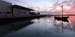
Geraldton is a coastal city in the Mid West region of the Australian state of Western Australia, 424 kilometres (263 mi) north of the state capital, Perth.

North West Coastal Highway is a generally north-south Western Australian highway which links the coastal city of Geraldton with the town of Port Hedland. The 1,300-kilometre-long (808 mi) road, constructed as a sealed two-lane single carriageway, travels through remote and largely arid landscapes. Carnarvon is the only large settlement on the highway, and is an oasis within the harsh surrounding environment. The entire highway is allocated National Route 1, part of Australia's Highway 1, and parts of the highway are included in tourist routes Batavia Coast Tourist Way and Cossack Tourist Way. Economically, North West Coastal Highway is an important link to the Mid West, Gascoyne and Pilbara regions, supporting the agricultural, pastoral, fishing, and tourism industries, as well as mining and offshore oil and gas production.

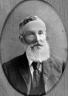
Admiral John Lort Stokes, RN was an officer in the Royal Navy who travelled on HMS Beagle for close to eighteen years.

John Clements Wickham was a Scottish explorer, naval officer, magistrate and administrator. He was first lieutenant on HMS Beagle during its second survey mission, 1831–1836, under captain Robert FitzRoy. The young naturalist and geologist Charles Darwin was a supernumerary on the ship, and his journal was published as The Voyage of the Beagle. After that expedition, Wickham was promoted to Commander and made captain of the Beagle on its third voyage, from 1837 and conducted various maritime expeditions and hydrographic surveys along the Australian coastline.

Yampi Sound is a part of the Indian Ocean off the coast of north-western Australia, in the Kimberley region of Western Australia. It is located between King Sound and Collier Bay. It lies between the Yampi Peninsula and the islands of the Buccaneer Archipelago, which contain important iron ore deposits.

John Nicol Drummond (1816–1906) was an early settler in Western Australia. He became the colony's first 'Inspector of Native Police', and helped to explore the Champion Bay district before becoming one of the district's pioneer pastoralists.
Francis Thomas "Frank" Gregory was an Australian explorer and politician.

Jurien Bay is a coastal town in the Wheatbelt region of Western Australia, 220 kilometres (137 mi) north of Perth facing the Indian Ocean.
Drummond Cove is a coastal town located 12 kilometres (7 mi) north of Geraldton, Western Australia in the local government area of the City of Greater Geraldton. The locality was gazetted in 1985.
West End is a western suburb of Geraldton, Western Australia. Its local government area is the City of Greater Geraldton.
Karloo is a locality southeast of Geraldton, Western Australia. Its local government area is the City of Greater Geraldton.
Batavia Road is an anchorage, or roadstead, in the Pelsaert Group of the Houtman Abrolhos, off the coast of Western Australia. It is located at 28°58′S113°58′E, on the eastern side of Pelsaert Island, near its southern end. It was discovered and named in April 1840 by John Clements Wickham, captain of HMS Beagle. Wickham's assistant John Lort Stokes later wrote:
"On the south west point of the island the beams of a large vessel were discovered, and as the crew of the Zeewyk, lost in 1728 [sic], reported having seen the wreck of a ship on this part, there is little doubt that the remains were those of the Batavia, Commodore Pelsart, lost in 1627. We in consequence named our temporary anchorage Batavia Road, and the whole group Pelsart Group."
Flag Hill is the highest hill on East Wallabi Island, and the highest point in the Houtman Abrolhos, an archipelago off the coast of Western Australia. It is located in the north-east of the island; its gazetted location is 28°26′7″S113°44′14″E, but in fact it is located somewhat east of there at about 28°26′02″S113°44′18″E. It is about 15 metres (50 ft) high.
Lort River is a river located in the Goldfields-Esperance region and the Eastern Mallee sub-region of Western Australia.
Stokes Inlet is an inlet in the Goldfields-Esperance region of Western Australia.

Hutt Lagoon is a marine salt lake located near the Indian Ocean coast 2 kilometres (1.2 mi) north of the mouth of the Hutt River, in the Mid West region of Western Australia.

Completed in 1849, the original 20-metre (66 ft) Wadjemup Lighthouse was Western Australia's first stone lighthouse and was built to provide a safer sailing passage for ships to Fremantle Port and the Swan River Colony.
H.M. Colonial Schooner Champion was in service with the Colony of Western Australia from 1836 until 1852.
References
- ↑ Gazetteer of Australia Archived October 9, 2012, at the Wayback Machine
- ↑ Stokes, John Lort (1846). "Chapter 5: Victoria River to Swan River". Discoveries in Australia, with an account of the coasts and rivers explored and surveyed during the voyage of the Beagle, 1837–1843, Volume 2. London: T and W. Boone. Retrieved 6 November 2014.
- ↑ "Expedition to the Northwest". The Perth Gazette and Western Australian Journal . 8 February 1840. p. 23. Retrieved 6 November 2014.
- ↑ Kimberly, Warren Bert (1897). "13. Land Laws; Exploration; Australiand Settlement 1839-1842". History of West Australia. Melbourne: F. W. Niven & Co. Retrieved 22 April 2014.
- ↑ Gregory, A.C. (15 March 1850). "Assist.-Surv.-Gregory's Report". The Perth Gazette and Independent Journal of Politics and News . p. 2. Retrieved 22 April 2014.
- ↑ "A93: Nhanhagardi". Austlang. AIATSIS. Retrieved 14 January 2020.
Coordinates: 28°45′S114°36′E / 28.750°S 114.600°E
| | This article about a location in Western Australia is a stub. You can help Wikipedia by expanding it. |