
Uttar Pradesh is a state in northern India. With over 200 million inhabitants, it is the most populous state in India as well as the most populous country subdivision in the world. It was created on 1 April 1937 as the United Provinces of Agra and Oudh during British rule, and was renamed Uttar Pradesh in 1950, giving it the acronym UP. The state is divided into 18 divisions and 75 districts, with the state capital being Lucknow, and Allahabad serving as the judicial capital. On 9 November 2000, a new state, Uttaranchal, was carved from the state's Himalayan hill region. The two major rivers of the state, the Ganges and Yamuna, join at Triveni Sangam in Allahabad and flow further east as Ganges. Other prominent rivers are Gomti and Saryu. The forest cover in the state is 6.1% of the state's geographical area. The cultivable area is 82% of total geographical area and net area sown is 68.5% of cultivable area.

Purvanchal is a geographic sub-region of Uttar Pradesh that is within the larger Bhojpuri region. It comprises the eastern end of Uttar Pradesh.

Gosainganj, also spelled Goshainganj or Gosaiganj is a town and nagar panchayat in Lucknow district of Uttar Pradesh, India. It is the seat of a community development block, which is included in the tehsil of Mohanlalganj. As of 2011, its population is 9,649, in 1,685 households. The starting point of the Purvanchal Expressway i.e. Chand Saray village is situated 2.5 km away from Gosainganj.

Akhilesh Yadav is an Indian politician and national president of the Samajwadi Party who served as the 20th Chief Minister of Uttar Pradesh from 2012 to 2017. Having assumed office on 15 March 2012 at the age of 38, he is the youngest person to have held the office. Yadav is the Member of Parliament for Azamgarh in the 17th Lok Sabha, being elected in 2019.

Yusufpur Mohammadabad is a town and a Township in Ghazipur district in the Indian state of Uttar Pradesh. Haydaria village near Mohammadabad is the starting point of Purvanchal Expressway.

The economy of Uttar Pradesh is the third largest of all the states of India. According to a report published by the Ministry of Statistics and Programme Implementation, Government of India the nominal GDP of the state for the year 2020-21 is ₹ 19.48 lakh crore. The largest Indian state, Maharashtra based on nominal GDP, has an urban population of 5,08,18,259, while Uttar Pradesh has an urban population of 4,44,95,063. According to the 2011 census report, 22.76% of Uttar Pradesh's population lives in urban areas. The state has 7 cities with populations exceeding 10 lakh each. After partition in 2000, the new Uttar Pradesh state produces about 92% of the economic output of the old Uttar Pradesh state. Currently, the poverty rate stands at 26.4%, just above the national average.
Ganga Expressway is an approved 594 km long, 6-lane wide greenfield expressway in the state of Uttar Pradesh, India. Phase-1 will connect Bijauli village on NH-334 in Meerut district with Judapur Dandu village on NH-19 in Prayagraj District. The project was launched on 29 January 2019 by the Chief Minister of Uttar Pradesh, Yogi Adityanath. The Uttar Pradesh cabinet met at Prayagraj, the venue of the Kumbh Mela and cleared the decks to construct the Ganga Expressway between Meerut and Prayagraj.
The demographics of Uttar Pradesh is a complex topic, which is undergoing dynamic change. Uttar Pradesh is India's most populous state, and the largest subdivision in the world. It has a population of about 199,812,341 as per the 2011 census. If it were a separate country, Uttar Pradesh would be the world's fifth most populous nation, next only to China, India, the United States of America and Indonesia. Uttar Pradesh has a population more than that of Pakistan. There is an average population density of 828 persons per km² i.e. 2,146 per sq mi. The capital of Uttar Pradesh is Lucknow, and Allahabad serves as the state’s judicial capital. Hindus and Muslims both consider the state as a holy place.
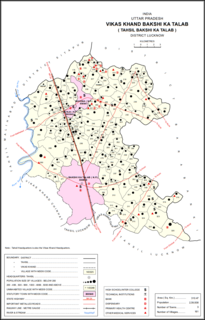
Bakshi Ka Talab is a nagar panchayat town in Lucknow district of Uttar Pradesh, India. It is also the headquarters of a corresponding tehsil, as well as a community development block of the same name. As of 2011, its population was 49,166, in 8,728 households. It consists of both residential and business settlements. Bakshi Ka Talab is an organised settlement developed by Lucknow Development Authority (LDA). It is connected to Lucknow via National Highway 24.
The Uttar Pradesh Expressways Industrial Development Authority (UPEIDA) is an authority set up by the Government of Uttar Pradesh to develop Expressway Projects in the state. The headquarters of UPEIDA is located at Paryatan Bhawan in Gomti Nagar, Lucknow, India.

The Agra–Lucknow Expressway is a 302 km long, 6-lane wide access-controlled expressway constructed by the Uttar Pradesh Expressways Industrial Development Authority (UPEIDA) to reduce traffic in already congested roads and to reduce pollution and carbon footprint. The Agra–Lucknow Expressway reduced the distance between the cities of Agra and Lucknow in the Indian state of Uttar Pradesh and is presently India's longest operation expressway since February 2017.
Baramadpur is a village in Akhand Nagar block of Kadipur division of Sultanpur district in Uttar Pradesh, India. More than 3,000 people live in Baramadpur. Baramadpur is 20 km from Shahganj and 27 km from Akbarpur on Nawab Yusuf Road. Baramadpur village is surrounded by Majhui River in north, Nawab Yusuf Road in east, Faizabad-Shahganj-Jaunpur Railway line in west and Kalwaribandh village in south.

Purvanchal Expressway is an under-construction 340.8 km long, 6-lane wide access controlled expressway in the state of Uttar Pradesh, India. The expressway will connect Chand Saray village near Gosainganj in Lucknow district with Haydaria village on NH-31 in Ghazipur district. It is being developed by the Uttar Pradesh Expressways Industrial Development Authority (UPEIDA) with a total project value of ₹22,494 crore, including the land acquisition cost. According to UPEIDA, it is expected to be opened by August 2021.

Saifai is a university town in the Etawah district of Indian state of Uttar Pradesh. It is also a sub-division (Tehsil) and Block of the Etawah district. It is the birthplace of Mulayam Singh Yadav, founding president of Samajwadi Party, former Minister of Defence and former Chief Minister of Uttar Pradesh. According to newspaper The Hindu, Saifai is in a process to establish itself as a sports and education hub in the state.
Bundelkhand Expressway is an 296 km long, 4-lane wide access controlled expressway in the state of Uttar Pradesh, India. It will connect Gonda village on NH-35 in Chitrakoot district with Agra–Lucknow Expressway at Kudrail village in Etawah district.
The Lucknow–Kanpur Expressway or National Expressway 6 (NE-6), is an 62 km long, 6-lane wide access controlled expressway in India's Uttar Pradesh state. The expressway will connect Kanpur and Lucknow and will run parallel to NH-27 which connects Kanpur and Lucknow with a distance of about 8.5 km (5.3 mi) between existing and proposed parallel roads. The expressway will start from its junction with NH-27 near Shaheed Path in South Lucknow connecting Bani, Kantha, Amarsas and terminating at its junction with NH No. 27 near Kanpur in the State of Uttar Pradesh.
Gorakhpur Link Expressway is an 91 km long, 4-lane wide expressway in the Indian state of Uttar Pradesh. It will connect Jaitpur village in Gorakhpur district with Purvanchal Expressway at Salarpur village in Azamgarh district. Salarpur village is situated between Azamgarh and Akbarpur. The project was launched in 2019 by the Chief Minister of Uttar Pradesh, Yogi Adityanath. The total project value of Gorakhpur Link Expressway, including the land acquisition cost is around ₹5,786 crores.
Sarai Damu is a village in Bakshi Ka Talab block of Lucknow district, Uttar Pradesh, India. As of 2011, its population is 1,081, in 219 households.
Miyanganj, also spelled Mianganj, is a village and corresponding community development block in Hasanganj tehsil of Unnao district, Uttar Pradesh, India. It is located on the road from Lucknow to Bangarmau, just to the west of the crossroads with another route linking Unnao and Sandila.

Fatehganj is a village in Purwa block of Unnao district, Uttar Pradesh, India. It is located on a major district road and has one primary school and no healthcare facilities. As of 2011, its population is 798, in 245 households.

