
The Corporation of Trinity House of Deptford Strond, also known as Trinity House, is the official authority for lighthouses in England, Wales, the Channel Islands and Gibraltar. Trinity House is also responsible for the provision and maintenance of other navigational aids, such as lightvessels, buoys, and maritime radio/satellite communication systems. It is also an official deep sea pilotage authority, providing expert navigators for ships trading in Northern European waters.

A lightvessel, or lightship, is a ship that acts as a lighthouse. They are used in waters that are too deep or otherwise unsuitable for lighthouse construction. Although some records exist of fire beacons being placed on ships in Roman times, the first modern lightvessel was off the Nore sandbank at the mouth of the River Thames in England, placed there by its inventor Robert Hamblin in 1734. The type has become largely obsolete; lighthouses replaced some stations as the construction techniques for lighthouses advanced, while large, automated buoys replaced others.
The history of lightvessels in the United Kingdom goes back over 250 years. This page lists the lightvessel stations within the United Kingdom, and also the Channel Islands and Gibraltar.

A light characteristic is a graphic and text description of a navigational light sequence or colour displayed on a nautical chart or in a Light List with the chart symbol for a lighthouse, lightvessel, buoy or sea mark with a light on it. The graphic indicates how the real light may be identified when looking at its actual light output type or sequence. Different lights use different colours, frequencies and light patterns, so mariners can identify which light they are seeing.
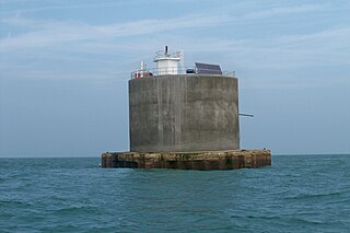
The Nab Tower was a tower planned for anti-submarine protection in the Solent in World War I. It was sunk over the Nab rocks east of the Isle of Wight to replace a lightship after the war, and is a well-known landmark for sailors as it marks the deep-water eastern entry into the Solent.
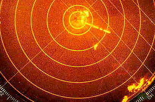
Radar beacon is – according to article 1.103 of the International Telecommunication Union's (ITU) ITU Radio Regulations (RR) – defined as "A transmitter-receiver associated with a fixed navigational mark which, when triggered by a radar, automatically returns a distinctive signal which can appear on the display of the triggering radar, providing range, bearing and identification information." Each station shall be classified by the service in which it operates permanently or temporarily.
North Foreland is a chalk headland on the Kent coast of southeast England, specifically in Broadstairs.

Sevenstones Lightship is a lightship moored off the Seven Stones Reef which is nearly 15 miles (24 km) to the west-north-west (WNW) of Land's End, Cornwall, and 7 miles (11 km) east-north-east (ENE) of the Isles of Scilly. The reef has been a navigational hazard to shipping for centuries with seventy-one named wrecks and an estimated two hundred shipwrecks overall, the most infamous being the oil tanker Torrey Canyon on 18 March 1967. The rocks are only exposed at half tide. Since it was not feasible to build a lighthouse, a lightvessel was provided by Trinity House. The first was moored near the reef on 20 August 1841 and exhibited its first light on 1 September 1841. She is permanently anchored in 40 fathoms (73 m) and is 2.5 miles (4.0 km) north-east (NE) of the reef. Since 1987, the Sevenstones Lightship has been automated and unmanned.
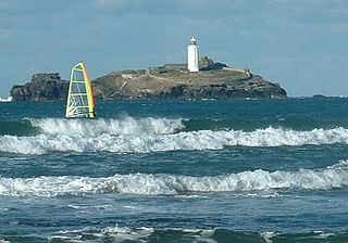
Godrevy Lighthouse was built in 1858–1859 on Godrevy Island in St Ives Bay, Cornwall. Standing approximately 300 metres (980 ft) off Godrevy Head, it marks the Stones reef, which has been a hazard to shipping for centuries.

St Bees Lighthouse is a lighthouse located on St Bees Head near the village of St Bees in Cumbria, England. The cliff-top light is the highest in England at 102 m (335 ft) above sea level.

Winterton Lighthouse is located in Winterton-on-Sea in the English county of Norfolk. In 1845 Winterton Ness was described as being 'well known to the mariner as the most fatal headland between Scotland and London'. As well as marking the headland, the lighthouse was intended to help guide vessels into the Cockle Gat, which provided the northern entry into the safe water of Yarmouth Roads. The lighthouse was known to Daniel Defoe and is mentioned in his novel Robinson Crusoe.

NLV Pharos is a lighthouse tender operated by the Northern Lighthouse Board (NLB), the body responsible for the operation of lighthouses and marine navigation aids around the coasts of Scotland and the Isle of Man.
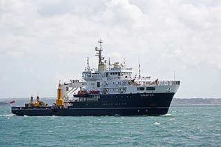
THV Galatea is a lighthouse tender operated by Trinity House, the body responsible for the operation of lighthouses and marine navigation aids around the coasts of England, Wales and the Channel Islands.

Gunfleet Lighthouse is a derelict screw-pile lighthouse lying in the North Sea, six miles off the coast at Frinton-on-Sea in Essex, constructed in 1850 by James Walker of Trinity House. George Henry Saunders was the contractor. Walker and Burges were the Engineers. It is 74 feet (23 m) in height and hexagonal in plan; mounted on seven piles forming a steel lattice and originally painted red. It was first lit on 1 May 1856, replacing a light vessel which had been on station there since 1850.

The Europa Point Lighthouse, also referred to as the Trinity Lighthouse at Europa Point and the Victoria Tower or La Farola in Llanito, is a lighthouse at Europa Point, on the southeastern tip of the British Overseas Territory of Gibraltar, on the southern end of the Iberian Peninsula, at the entrance to the Mediterranean Sea.

Lowestoft Lighthouse is a lighthouse operated by Trinity House located to the north of the centre of Lowestoft in the English county of Suffolk. It stands on the North Sea coast close to Ness Point, the most easterly point in the United Kingdom. It acts as a warning light for shipping passing along the east coast and is the most easterly lighthouse in the UK.

Dungeness Lighthouse on the Dungeness Headland started operation on 20 November 1961. Its construction was prompted by the building of Dungeness nuclear power station, which obscured the light of its predecessor which, though decommissioned, remains standing. The new lighthouse is constructed of precast concrete rings; its pattern of black and white bands is impregnated into the concrete. It remains in use today, monitored and controlled from the Trinity House Operations and Planning Centre at Harwich, Essex.

The Bahama Bank Lightship was a Lightvessel stationed on the Bahama Bank east of Ramsey Bay, Isle of Man.

Lundy has three lighthouses: a pair of active lights built in 1897 and an older lighthouse dating from 1797.
