
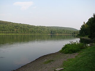
The Allegheny River is a 325-mile-long (523 km) headwater stream of the Ohio River that is located in western Pennsylvania and New York in the United States. It runs from its headwaters just below the middle of Pennsylvania's northern border, northwesterly into New York, then in a zigzag southwesterly across the border and through Western Pennsylvania to join the Monongahela River at the Forks of the Ohio at Point State Park in Downtown Pittsburgh, Pennsylvania.

Warren County is a county in the Commonwealth of Pennsylvania. As of the 2020 census, the population was 38,587. Its county seat is Warren. The county was established in 1800 from parts of Allegheny and Lycoming counties; attached to Crawford County until 1805 and then to Venango County until Warren was formally established in 1819.

Monroe County is a county in the Commonwealth of Pennsylvania. As of the 2020 census, the population was 168,327. Its county seat is Stroudsburg. The county is part of the Northeast Pennsylvania region of the state.

Erie County is a county in the Commonwealth of Pennsylvania. It is the northernmost county in Pennsylvania. As of the 2020 census, the population was 270,876. Its county seat is Erie. The county was created in 1800 and later organized in 1803. The county is part of the Erie–Meadville combined statistical area.

Butler County is a county in the Commonwealth of Pennsylvania. As of the 2020 census, the population was 193,763. Its county seat is Butler. Butler County was created on March 12, 1800, from part of Allegheny County and named in honor of General Richard Butler, a hero of the American Revolution. The county is part of the Greater Pittsburgh region of the state.

Butler Township is a township in Butler County, Pennsylvania, United States. The population was 17,230 at the 2020 census. The township was first settled by Europeans in 1795. It was established as a township in 1804 and as a first class township in 1922.

Renovo is a borough in Clinton County, Pennsylvania, United States, 28 miles (45 km) northwest of Lock Haven. In 1900, 4,082 people lived there, and in 1910, 4,621 lived there, but in the 2010 census the borough population was 1,228.

Caesar Creek State Park is a public recreation area located in southwestern Ohio, five miles (8 km) east of Waynesville, in Warren, Clinton, and Greene counties. The park is leased by the State from the U.S. Army Corps of Engineers, who in the 1970s erected a dam on Caesar Creek to impound a 2,830-acre (1,150 ha) lake. The total park area, including the lake, is 7,530-acre (3,050 ha).
Delaware Water Gap National Recreation Area is a 70,000-acre (28,000 ha) national recreation area administered by the National Park Service in northwest New Jersey and northeast Pennsylvania. It is centered around a 40-mile (64 km) stretch of the Delaware River designated the Middle Delaware National Scenic River. At the area's southern end lays the Delaware Water Gap, a dramatic mountain pass where the river cuts between Blue Mountain and Kittatinny Mountain.

Shawnee State Park is a 3,983-acre (1,612 ha) Pennsylvania state park in Juniata and Napier Townships, Bedford County, Pennsylvania in the United States. Shawnee Lake, a 451-acre (183 ha) warm water reservoir, is at the center of the park as its main attraction. The park's main entrance is just east of Schellsburg, along U.S. Route 30 and about 10 miles (16 km) west of the county seat of Bedford. The park is also easily accessed via State Route 31 and by State Route 96.
Cornplanter State Forest is a Pennsylvania State Forest in Pennsylvania Bureau of Forestry District #14. The main office is located in North Warren in Warren County, Pennsylvania, in the United States. It is named for Chief Cornplanter of the Seneca Nation, one of the tribes of the Iroquois Confederacy.
Conewango Creek is a 71-mile-long (114 km) tributary of the Allegheny River in Pennsylvania and western New York in the United States.

Hyner Run State Park is a 180-acre (73 ha) Pennsylvania state park in Chapman Township, Clinton County, Pennsylvania in the United States. The park is 6 miles (9.7 km) east of Renovo and 3 miles (5 km) north of Hyner on Pennsylvania Route 120. Hyner Run State Park is surrounded by Sproul State Forest.

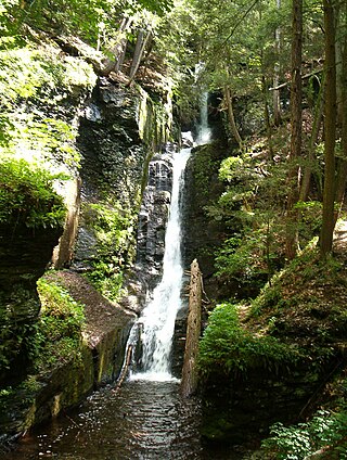
Chapman State Park is a 862-acre (349 ha) Pennsylvania state park in Pleasant Township, Warren County, Pennsylvania near Clarendon, in the United States. The man-made Chapman Lake covers 68 acres (28 ha) of the park. Chapman State Park is named in honor of Dr. Leroy E. Chapman. Dr. Chapman was a state senator from 1929 until 1963. He was part of several civic groups that pushed for the creation of a state park in Warren County. Chapman State Park, opened in 1951, is adjacent to Allegheny National Forest and State Game Land 29 just off U.S. Route 6.
Prompton State Park is a Pennsylvania state park on 2,000 acres (809 ha) in Clinton and Dyberry Townships, Wayne County, Pennsylvania in the United States. This park, which was established in 1962, is officially listed by the Pennsylvania Department of Conservation and Natural Resources as being undeveloped. This means that it is officially a state park but the PA-DCNR is not currently managing the park. However, the lands of the park are open to visitors. Friends of Prompton State Park, a grassroots organization is working to take over management of the park in much the same way that Salt Springs State Park in Susquehanna County is managed by The Friends of Salt Springs Park. Northeast Sports Ltd. of Honesdale sponsors several outdoor sports events that are held at the park. Prompton State Park is 4.2 miles (6.8 km) west of Honesdale on Pennsylvania Route 170.

Penns Valley is an eroded anticlinal valley of the Pennsylvania ridge and valley geologic region of the Appalachian Mountain range. The valley is located in southern Centre County, Pennsylvania. Along with the Nittany Valley to the north and east, it is part of the larger Nittany Anticlinorium. It is bordered by Mount Nittany to the north, the Seven Mountains range to the south, and connects to the larger Nittany Valley to the west. There are two smaller subordinate valleys typically associated with the greater valley: Georges Valley in the south, separated by Egg Hill, and Brush Valley in the north, separated by Brush Mountain.
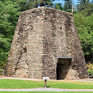
Pine Grove Furnace State Park is a protected Pennsylvania area that includes Laurel and Fuller Lakes in Cooke Township of Cumberland County. The Park accommodates various outdoor recreation activities, protects the remains of the Pine Grove Iron Works (1764), and was the site of Laurel Forge (1830), Pine Grove Park (1880s), and a brick plant (1892). The Park is 8 miles (13 km) from exit 37 of Interstate 81 on Pennsylvania Route 233.
Transportation in Erie, Pennsylvania includes access to most major forms of transportation, including automobile, bus, train, taxi, airplane, and ship. The city generates income through the transportation industry, including train manufacturing and port operations.
The Pennsylvania State Game Lands Number 314 are Pennsylvania State Game Lands in Erie County in Pennsylvania in the United States primarily used for deer, turkey, fox, squirrel, gray squirrel, and American woodcock hunting. The park is borderer on its western edge by Ohio and on the north by Lake Erie.


