Charco del Palo

Last updated
Charco del Palo
Village
Bathing at Charco del Palo.jpg
Lanzarote (Canary Islands) - OSM Mapnik.svg
Red pog.svg
Charco del Palo
Espana-Canarias-loc.svg
Red pog.svg
Charco del Palo
Coordinates: 29°05′N13°27′W / 29.083°N 13.450°W / 29.083; -13.450
Founded byGregor Kaiser
Population
 (2013)
  Total156 [1]

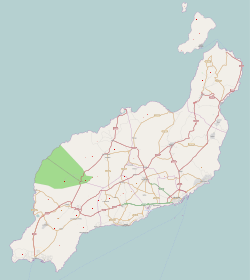
Charco del Palo is a naturist holiday village [2] on the north-eastern coast of Lanzarote, in the Canary Islands. The village was established around 1970 by the German entrepreneur Gregor Kaiser. In due course, it has developed into a popular naturist resort. [3] It was the first official naturist resort established in the Canaries: [4] nudity is permitted everywhere in the village, and practised universally. Its isolated location, at the end of a dedicated three kilometer long access road, helps to achieve privacy, while the village remains open to all. Visitors are mainly German, British, and Dutch. The village's population increased from 82 in the year 2000 to 229 in 2011, it has subsequently declined to 156 in 2013. [5]

Contents

The development was originally named Castillo de Papagayo, but since this causes confusion with the well-known Playa de Papagayo nude beach in the region of Playa Blanca in southern Lanzarote, the name Charco del Palo, which refers to a nearby prominent coastal pool now developed for bathing, [6] has become standard.

Most of the bungalows and apartments are private property; many are being rented [7] out when their owners are not using them. The German nudist travel organization Oböna owns an apartment complex here as well. The village has a few restaurants (Lily's Bar, Jardin Tropical, and Cueva Paloma) and a small supermarket. The terraces of Lily's Bar, Jardin Tropical and Cueva Paloma do allow (and frequently see) naked use.

The village is built on pale sandy soil, but the coast is rocky, with no beaches. However, three sheltered coves have been developed for safe bathing.

Charco del Palo is located near the villages of Mala and Guatiza, both about 3 kilometres (1.9 mi) away, which are served by a regular bus route between the island's capital Arrecife and the north of the island. The surrounding countryside is dominated by fields of prickly pear cactus (known locally as tunera), on which cochineal beetles are reared, and a few small extinct volcano cones.

The village lies mostly within the municipality of Haría, but the border with Teguise cuts through the southern part. All the public land in the area is owned by the original developer, who is responsible for providing public services. However, in recent times, residents have been complaining about neglect of public services such as sewerage, paving, and public lighting, and have been campaigning for the municipalities to assume responsibility for maintenance. [8] [9] [10]
Notes and references

  1. "Nomenclátor. Relación de unidades poblacionales". Instituto Nacional de Estadística (Spanish Statistical Institute). Retrieved 2012-03-01.
  2. Corne 2004, pp. 155–.
  3. Andrews & Quintero 2007, pp. 132–.
  4. Carlos Inza (18 August 2016). "Refugio de naturistas". Canarias7. Archived from the original on 2016-09-24. Retrieved 2016-09-14.
  5. "Nomenclátor. Relación de unidades poblacionales". Instituto Nacional de Estadística (Spanish Statistical Institute). Retrieved 2012-03-01.
  6. "Territorial Information System". Canaries Government. Retrieved 2012-11-19.
  7. Reisenegger 2006, pp. 49–.
  8. "Los socialistas de Haría y Teguise se comprometen a equiparar en servicios al Charco del Palo (The socialists of Haría and Teguise promise to investigate services at Charco del Palo)". Spanish Socialist Workers' Party, Socialistas de Lanzarote. 23 February 2011. Archived from the original on 13 March 2013. Retrieved 2012-03-11.
  9. "Las víctimas de los desmanes urbanísticos (The victims of development abuses)". La Voz de Lanzarote. 22 July 2011. Archived from the original on 2013-03-17.
  10. Ruth Gabilondo (23 July 2011). "El Charco del Palo muestra sus vergüenzas (Charco del Palo shows its shame)". La Voz de Lanzarote. Archived from the original on 2012-01-14.

Further reading

Related Research Articles

<span class="mw-page-title-main">Lanzarote</span> Island of the Canary Islands, Spain

Lanzarote is a Spanish island, the easternmost of the Canary Islands in the Atlantic Ocean. It is located approximately 125 kilometres off the north coast of Africa and 1,000 kilometres from the Iberian Peninsula. Covering 845.94 square kilometres, Lanzarote is the fourth-largest of the islands in the archipelago. With 152,289 inhabitants at the start of 2019, it is the third most populous Canary Island, after Tenerife and Gran Canaria. Located in the centre-west of the island is Timanfaya National Park, one of its main attractions. The island was declared a biosphere reserve by UNESCO in 1993. The island's capital is Arrecife, which lies on the eastern coastline. It is the smaller main island of the Province of Las Palmas.

<span class="mw-page-title-main">Yaiza (municipality)</span> Municipality in Canary Islands, Spain

Yaiza is a municipality on the island of Lanzarote in the Canary Islands, Spain. It lies in the southwest of the island and forms part of the province of Las Palmas. The municipality is bounded by the Atlantic Ocean to the west, south and east. To the north, the Timanfaya National Park is partly within the municipality. The eastern part of the municipality is mountainous and, south west of the mountains, the Rubicon plain stretches to the coast.

<span class="mw-page-title-main">Arrecife</span> City in Canary Islands, Spain

Arrecife is the capital city and a municipality of Lanzarote in the Canary Islands. It was made the island's capital in 1852. The city owes its name to the rock reef which covers its local beach. It also gives its name to the nearby Arrecife Airport. The population of the municipality was 64,645 in 2020. Its area is 22.72 square kilometres (8.77 sq mi).

<span class="mw-page-title-main">Puerto del Carmen</span> Town in Canary Islands, Spain

Puerto del Carmen is the main tourist town on the island of Lanzarote, Canary Islands, Spain. It is part of the municipality of Tías. Most of Lanzarote's over 1 million visitors per year choose this town as their destination. As a result, almost all of the town's economy revolves around tourism.

<span class="mw-page-title-main">Graciosa, Canary Islands</span> Island of the Chinijo Archipelago in the Canary Islands, Spain

Graciosa Island or commonly La Graciosa is a volcanic island in the Canary Islands of Spain, located two kilometres north of Lanzarote across the Strait of El Río. It was formed by the Canary hotspot. The island is part of the Chinijo Archipelago and the Chinijo Archipelago Natural Park. It is administered by the municipality of Teguise in the neighboring island of Lanzarote. In 2018 La Graciosa officially became the eighth Canary Island with few real effects. Before then, the island had the status of an islet, administratively dependent on the island of Lanzarote. The only two settlements on the island are Caleta de Sebo in the southeastern part of the island and summer-residence Casas de Pedro Barba.

<span class="mw-page-title-main">Haría (municipality)</span> Municipality in Canary Islands, Spain

Haría is a municipality on the island of Lanzarote in the Canary Islands, the northernmost and easternmost Canarian municipality. Surrounded on three sides by the Atlantic Ocean, the municipality is bordered to the south by the municipality of Teguise. It forms part of Las Palmas Province. The seat of the municipality is the town of Haría. The population of the municipality was 4,872 in 2013. The total land area of the municipality is 106.59 square kilometres (41.15 sq mi).

<span class="mw-page-title-main">Teguise (municipality)</span> Municipality in Canary Islands, Spain

Teguise is a municipality in the central part of the island of Lanzarote in the Las Palmas province in the Canary Islands. The population is 22,342, and the area is 263.98 km2. It is located north of Arrecife and south of Haría. The seat of the municipality is the town of Teguise. The municipality also comprises a number of neighbouring islands including Graciosa, Alegranza, Roque del Este, Roque del Oeste and Montaña Clara.

<span class="mw-page-title-main">César Manrique</span> Spanish painter

César Manrique Cabrera was a Spanish artist, sculptor and nature activist from Lanzarote, known particularly for the architectural projects in which he was involved as artistic director in his island.

<span class="mw-page-title-main">Cueva de los Verdes</span>

Cueva de los Verdes is a lava tube and tourist attraction of the Haria municipality on the island of Lanzarote in the Canary Islands (Spain). The cave lies within the Monumento Natural del Malpaís de La Corona, a protected area of the Canary Islands.

<span class="mw-page-title-main">Costa Teguise</span> Town in Canary Islands, Spain

Costa Teguise is a coastal town in the Municipality of Teguise on the island of Lanzarote. It was built intentionally to accommodate tourism, and prior to building commencing the streets were planned, constructed, and serviced in advance.

<span class="mw-page-title-main">Órzola</span> Place in Canary Islands, Spain

Órzola is a village in the municipality of Haría on the island of Lanzarote in the Canary Islands. It is the northernmost settlement of the island. As of 2021, it has a population of 352 inhabitants.

<span class="mw-page-title-main">Caleta de Sebo</span> Town in Canary Islands, Spain

Caleta de Sebo is the main settlement and capital community of La Graciosa.

<span class="mw-page-title-main">Arrieta, Lanzarote</span> Village in Canary Islands, Spain

Arrieta is a small coastal village on the municipality of Haría, which is the northernmost municipality of island of Lanzarote. In 2021, the population of Arrieta was of 1064 inhabitants. The beach is famous and very popular among locals and tourists. As a tourist destination it is pretty crowded in the seasons and there are amenities for ~2000 guests in the direct vicinity of Arrieta.

<span class="mw-page-title-main">Casas de Pedro Barba</span> Place in Canary Islands, Spain

Casas de Pedro Barba, or simply Pedro Barba, is a small community of summer residences on the island of La Graciosa, Canary Islands, Spain. Its population, as of 1 January 2018 and according to the Spanish Statistical Institute, is of 3 inhabitants. It is part of the municipality of Teguise on the neighbouring island of Lanzarote. There are no asphalted roads on La Graciosa; a dirt track connects the settlement to the only other inhabited town on the island, Caleta de Sebo, from which a regular ferry service is offered to Lanzarote.

<span class="mw-page-title-main">Monte Corona</span>

Volcán de La Corona is a 609 meters (1,998 ft) high extinct volcano on the Canary Island of Lanzarote (Spain), near the village of Yé in the municipality of Haría. Its eruption around 4000 years ago covered a large area of the northeast of the island with lava, creating the Malpais de la Corona and two of the island's most-visited geological attractions, the Cueva de los Verdes and the Jameos del Agua.

<span class="mw-page-title-main">Mala, Lanzarote</span>

Mala is a village in the municipality of Haría on Lanzarote in the province of Las Palmas in the Canary Islands. Its population in 2012 was 533.

Playa de la Cocina is a beach on La Graciosa island, part of the municipality of Teguise in Lanzarote, Spain. It is situated near the southwestern point of the island, in a little bay at the foot of the Montaña Amarilla. It is a 10 minutes walk from Playa Francesa in the southwest of the Caleta de Sebo village. The beach's average width is 10 meters and length is 100 metres.

Famara is the main mountainous massif in the north of the island of Lanzarote in the Canary Islands. It is the eastern slope of a volcano erupting in the Miocene. The cliffs of Famara are the remains of a caldera of about ten kilometres in diameter centred on the south of La Graciosa.

The Papagayo are strong winds that blow north of the Gulf of Papagayo.