Albion is an inner north-eastern suburb in the City of Brisbane, Queensland, Australia. In the 2016 census, Albion had a population of 2,296 people.

Aspley is a suburb in the City of Brisbane, Queensland, Australia. In the 2016 census, Aspley had a population of 12,108 people.

Chermside is a suburb in the City of Brisbane, Queensland, Australia. In the 2016 census Chermside had a population of 9,315 people. The suburb is situated 9.8 kilometres (6.1 mi) by road north of the Brisbane CBD. It is home to a large Westfield shopping centre.

St Lucia is a riverside suburb in the City of Brisbane, Queensland, Australia. In the 2016 census St Lucia had a population of 12,574 people.

The Redcliffe Peninsula is a peninsula located in the Moreton Bay Region LGA in the northeast of the Brisbane metropolitan area in Queensland, Australia. The area covers the suburbs of Clontarf, Kippa-Ring, Margate, Newport, Redcliffe, Rothwell, Scarborough and Woody Point.

Dutton Park is an inner southern suburb of the City of Brisbane, Queensland, Australia. In the 2016 census, Dutton Park had a population of 2,024 people.
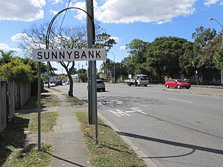
Sunnybank is a suburb in the City of Brisbane, Queensland, Australia. In the 2016 census, Sunnybank had a population of 8,697 people, with 31.0% describing their ancestry as Chinese, with 19.0% of Sunnybank's people being born in China, 9.3% in Taiwan, and 2.6% in Hong Kong. It is known for its many Asian shops and restaurants.

Pinkenba is a town and coastal eastern suburb within the City of Brisbane, Queensland, Australia. In the 2016 census, Pinkenba had a population of 368 people.
Lutwyche is a northern suburb in the City of Brisbane, Queensland, Australia. In the 2016 census, Lutwyche had a population of 3,454 people.
Nundah is an inner suburb in the City of Brisbane, Queensland, Australia. It contains the neighbourhood of Toombul. In the 2016 census, Nundah had a population of 12,141 people.

Kalinga is a suburb in the City of Brisbane, Queensland, Australia. In the 2016 census Kalinga had a population of 2,126 people.

Yeronga is a residential suburb of the City of Brisbane, Queensland, Australia located on the Brisbane River 7 kilometres (4.3 mi) south of the Brisbane central business district.

Hendra is a suburb of the City of Brisbane, Queensland, Australia. In the 2016 census, Hendra had a population of 4,625 people.

Newmarket is an inner north-west suburb in the City of Brisbane, Queensland, Australia. It is an older, mostly residential suburb containing pre-war and post-war homes, including many fine examples of the Queenslander style of home. Over the last few years, some medium-density townhouses and unit blocks have appeared as well. In the 2016 census, Newmarket had a population of 4,979 people.

Logan Road, allocated state routes 95 and 30, is a major road in Brisbane, Queensland. It runs 18 kilometres (11 mi) from Springwood in Logan City to Woolloongabba in Brisbane, with most of the route signed as state route 95. The route was formerly the main route to the Gold Coast from Brisbane, until the South East Freeway was built.

Nudgee Beach is a suburb and beach in the City of Brisbane, Queensland, Australia. In the 2016 census, the suburb had a population of 263 people.

Cannon Hill is a suburb in the City of Brisbane, Queensland, Australia. In the 2016 census Cannon Hill had a population of 5,533 people.
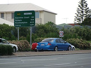
Gympie Road is a major road in the northern suburbs of Brisbane, Queensland, Australia. The road forms part of the main road route from the Brisbane Central Business District (CBD) to the northern suburbs, Sunshine Coast and east coast of Queensland.

Kingsford Smith Drive is a major road in Brisbane. The road was named after the aviator Charles Kingsford Smith. It connects the suburb of Pinkenba to the Brisbane central business district at the Breakfast Creek. Kingsford Smith Drive is one of the busiest roads in Brisbane, carrying an average of 61,773 vehicles per day between July and December 2014.

Enoggera Road is a major road in Brisbane, Queensland, Australia. It is the main access road that connects the north-west Brisbane suburbs to Enoggera Creek towards the inner suburbs and the Brisbane CBD.
