
Valley is a city in Chambers County, Alabama, United States. Valley was incorporated in 1980 combining the four textile mill villages of Fairfax, Langdale, River View, and Shawmut. As of the 2010 census it had a population of 9,524. The city lies on the western bank of the Chattahoochee River, the state border between Alabama and Georgia. Valley is a pilot city for the Alabama Communities of Excellence program, a non-profit that partners with governments, businesses, and universities to prepare participating communities for a more vibrant future. It is included in the LaGrange, Georgia Micropolitan Statistical Area, which is included in the Greater Atlanta Combined Statistical Area.

The Chattahoochee River forms the southern half of the Alabama and Georgia border, as well as a portion of the Florida - Georgia border. It is a tributary of the Apalachicola River, a relatively short river formed by the confluence of the Chattahoochee and Flint rivers and emptying from Florida into Apalachicola Bay in the Gulf of Mexico. The Chattahoochee River is about 430 miles (690 km) long. The Chattahoochee, Flint, and Apalachicola rivers together make up the Apalachicola–Chattahoochee–Flint River Basin. The Chattahoochee makes up the largest part of the ACF's drainage basin.

Sope Creek is an 11.6-mile-long (18.7 km) stream located in Cobb County, Georgia, United States. It is a significant tributary of the Chattahoochee River. It was known as Soap Creek during the 19th century. A section of Sope Creek runs through the Chattahoochee River National Recreation Area.

The Washington and Old Dominion Railroad Regional Park is a linear regional park in Northern Virginia. The park's primary feature is the Washington and Old Dominion Railroad Trail, an asphalt-surfaced paved rail trail that runs through densely populated urban and suburban communities as well as through rural areas. Most of the trail travels on top of the rail bed of the former Washington and Old Dominion Railroad, which closed in 1968.
The Chattahoochee Valley Railway was a shortline railroad linking a number of textile mills between West Point, Georgia and McGinty, Alabama for a total distance of 9.5 miles (15.3 km). As a subsidiary of West Point Pepperell, the entire railroad was abandoned in 1992.
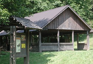
Chattahoochee River National Recreation Area (CRNRA) preserves a series of sites between Atlanta and Lake Sidney Lanier along the Chattahoochee River in Georgia, U.S. The 48-mile (77 km) stretch of the river affords public recreation opportunities and access to historic sites. The national recreation area, a National Park Service unit, was established on August 15, 1978, by President Jimmy Carter.

Iron Horse State Park, part of the Washington State Park System, is a 1,612-acre (7 km2) state park located in the Cascade Mountains and Yakima River Valley, between Cedar Falls on the west and the Columbia River on the east.

The Air Line State Park Trail is a rail trail and linear state park located in Connecticut. The trail is divided into sections designated South, North a piece of the East Coast Greenway, and the Thompson addition. An additional 3.6 mile spur to Colchester is sometimes designated as part of the Air Line trail. At the Massachusetts state line, the trail connects to the Southern New England Trunkline Trail, a 22 mile long trail to Franklin, MA built on the same right-of-way. Since 2018, the town of Portland, CT has also maintained a 2.3 mile portion of the Airline Trail, connecting to the southern end of the state park at the town line with East Hampton.
The Banks–Vernonia State Trail is a paved rail trail and state park in northwest Oregon in the United States. It runs for 21 miles (34 km), primarily north–south, between the towns of Vernonia in Columbia County and Banks in Washington County on an abandoned railroad bed. Banks is about 25 miles (40 km) west of Portland.
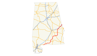
U.S. Highway 29 (US 29), internally designated by the Alabama Department of Transportation as State Route 15 (SR 15), is a southwest–northeast state highway across the southeastern part of the U.S. state of Alabama. US 29 and SR 15 traverse Alabama in a general northeast–southwest slope. It has never been a major route in the state; its significance was completely overshadowed with the completion of Interstate 65 (I-65) and I-85 during the 1970s. Today, US 29 and SR 15 serve primarily to connect numerous smaller towns and cities in the southwest, south-central, and eastern parts of Alabama.

The Delaware & Lehigh Canal National and State Heritage Corridor (D&L) is a 165-mile (266 km) National Heritage Area in eastern Pennsylvania in the United States. It stretches from north to south, across five counties and over one hundred municipalities. It follows the historic routes of the Lehigh and Susquehanna Railroad, Lehigh Valley Railroad, the Lehigh Navigation, Lehigh Canal, and the Delaware Canal, from Bristol to Wilkes-Barre in the northeastern part of the state. The backbone of the Corridor is the 165-mile (266 km) D&L Trail. The Corridor's mission is to preserve heritage and conserve green space for public use in Bucks, Northampton, Lehigh, Carbon, and Luzerne counties in Pennsylvania. It also operates Hugh Moore Historical Park & Museums, which includes the National Canal Museum.

The Wallkill Valley Rail Trail is a 22.5-mile (36.2 km) rail trail and linear park that runs along the former Wallkill Valley Railroad rail corridor in Ulster County, New York. It stretches from Gardiner through New Paltz, Rosendale and Ulster to the Kingston city line, just south of a demolished, concrete Conrail railroad bridge that was located on a team-track siding several blocks south of the also-demolished Kingston New York Central Railroad passenger station. The trail is separated from the Walden–Wallkill Rail Trail by two state prisons in Shawangunk, though there have been plans to bypass these facilities and to connect the Wallkill Valley Rail Trail with other regional rail-trails. The northern section of the trail forms part of the Empire State Trail.
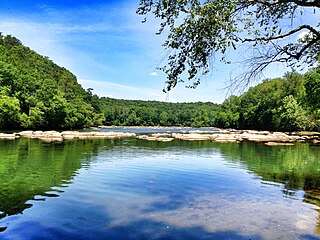
Riverview Historic District is a historic district along the Chattahoochee River in River View, Alabama. It was listed on the Alabama Register of Landmarks and Heritage on December 19, 1991, and on the National Register of Historic Places on November 12, 1999.
River View is a subdivision of Valley, Alabama on the Chattahoochee River. On May 20, 1980, the communities of Shawmut, Langdale, Fairfax, and River View merged to form the city of Valley. It is the location of Riverview Historic District, which is listed on the U.S. National Register of Historic Places.
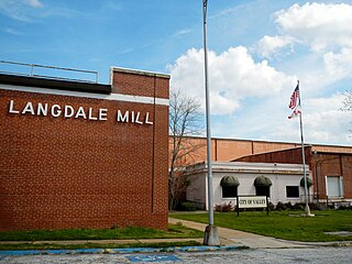
Langdale Historic District is a historic district in Valley, Alabama and Harris County, Georgia, United States. It was listed on the Alabama Register of Landmarks and Heritage on July 22, 1991, and the National Register of Historic Places (NRHP) on November 12, 1999. It lies primarily in Valley, Alabama, on the West side of the Chattahoochee River.

The Rosendale Trestle is a 940-foot (290-meter) continuous truss bridge and former railroad trestle in Rosendale Village, a hamlet in the town of Rosendale in Ulster County, New York. Originally constructed by the Wallkill Valley Railroad to continue its rail line from New Paltz to Kingston, the bridge rises 150 ft (46 m) above Rondout Creek, spanning both Route 213 and the former Delaware and Hudson Canal. Construction on the trestle began in late 1870, and continued until early 1872. When it opened to rail traffic on April 6, 1872, the Rosendale trestle was the highest span bridge in the United States.

Mississippi Central Railroad is a short line railroad operating over 51 miles from Oxford, Mississippi, to Grand Junction, Tennessee, owned by Pioneer Railcorp. The railroad's principal commodities are wood products and fertilizer. The MSCI offers connections to the BNSF Railway in Holly Springs and Norfolk Southern Railway in Grand Junction.
The Arabia Mountain Path (AMP) is a paved biking and hiking trail connecting sites within the Arabia Mountain National Heritage Area, built by the PATH Foundation. The trail covers more than 30 linear miles and features hills, sections of boardwalk, a serpentine bridge, and access to 13 free trail head parking areas. The AMP connects a number of visitor destinations and recreational areas including Panola Mountain State Park, the Monastery of the Holy Spirit, Davidson-Arabia Mountain Nature Preserve, the Mall at Stonecrest, and historic Lithonia, Georgia.

The Citronelle Walking Trail is a three-mile long, asphalt-covered rail trail in Citronelle, Alabama. It was designated as a National Recreation Trail in 2011.

