As of 2011, the population of Chaugain was 12,611, in 2,124 households, while the total population of Chaugain block was 48,743, in 7,929 households.[2]
Chaugain is a rural block, with no large urban centres. The sex ratio of the block was 948 as of 2011, with a ratio of 939 in the 0-6 age bracket at the time. Members of scheduled castes made up 16.02% of the block population, and members of scheduled tribes made up 0.61%. The literacy rate of Chaugain block was 69.43%, including 80.89% among men and 57.27% among women.[2]
Most workers in Chaugain worked in agriculture in 2011, with 29.69% being cultivators who owned or leased their own land and a further 55.02% being agricultural labourers who worked someone else's land for wages. 2.29% were household industry workers, and the remaining 13.01% were other workers.[2]
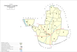
Villages
There are 23 villages in Chaugain block, 20 of which are inhabited and 3 of which are uninhabited.[2]
This page is based on this Wikipedia article Text is available under the CC BY-SA 4.0 license; additional terms may apply. Images, videos and audio are available under their respective licenses.