
Sawai Madhopur district is a district of Rajasthan state in north-west India. Sawai Madhopur is the chief town and district headquarters. Sawai Madhopur district comes under Bharatpur division.

Sawai Madhopur is a city and Municipal Council in the Sawai Madhopur District in Rajasthan state, India. It is the administrative headquarter of Sawai Madhopur District in Rajasthan. Ranthambore National Park which is 7 km from the railway station, and Ranthambore Fort, a UNESCO World Heritage Site are located near Sawai Madhopur.

Dausa District is a district of Rajasthan state in India within Jaipur division. The city of Dausa is the district headquarters. It has an area of 3432 km² and a population of 1,634,409 in 2011 census. It is surrounded by Alwar District in the north, Bharatpur district in the northeast, Karauli district in the southeast, Sawai Madhopur district in the south, and Jaipur district in the west. The Sawa and Banganga rivers run through the district. It is situated on the National Highway 21 from Jaipur to Agra. It is 55 km to the east of Jaipur and 103 km from Sawai Madhopur.

Sri Madhopur is a city and a municipality, in Neem Ka Thana district in the Indian state of Rajasthan. It was founded on 18 April 1761 under the reign of Maharaja Sawai Madho Singh I. It was mainly famous for his temples. Shrimadhopur's Wheat market is the biggest wheat market in Neem ka thana district. Shrimadhopur Government school is one of the biggest school of the Neem Ka Thana district. It is one of the five tehsils of the district. Dedicated Delhi-Mumbai Freight Corridor is passing through this city. This city is chosen for the development of crossing station on this route.
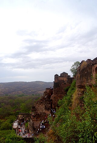
Ranthambore Fort lies within the Ranthambore National Park, near the city of Sawai Madhopur in Sawai Madhopur district of Rajasthan, India. the park being the former hunting grounds of the Maharajahs of Jaipur until the time of India's Independence. It is a formidable fort having been a focal point of the historical developments of Rajasthan. The fort is believed to be constructed by numerous kings from Several Dynasties including Yadav lineage, Chahamana Rajputs, Hada Rajputs, Mewar Rajput Kings and then the Delhi Sultanate captured it for a brief time. The fort provides a panoramic view of the surrounding Ranthambore National Park and is now a popular tourist attraction.
Khandar Fort is an ancient fort located in Khandar Tehsil, Sawai Madhopur district, Rajasthan, India. This fort is on the boundary of Ranthambore National Park. The fort has three big entrances, but they are damaged.
Khandar is a town and tehsil in district Sawai Madhopur, Rajasthan. The river Banas flows through Khandar.
Tonk–Sawai Madhopur is one of the 25 Lok Sabha (parliamentary) constituencies in Rajasthan state in western India. This constituency came into existence in 2008 as a part of the implementation of delimitation of parliamentary constituencies.
The Morel River originates in the hills near Dharla and Chainpura villages in Bassi Tehsil of Jaipur District, second branch makes by receiving water from the catchment area of foothills of Paplaj Mataji mountains, district Dausa, Rajasthan.

Sawai Madhopur Junction Railway Station is a major railway station on New Delhi–Mumbai main line and Jaipur–Mumbai rail line of the West Central Railway zone network. It is very well connected to Gangapur city, Bayana junction, Bharatpur, Mathura, Kanpur Central, Delhi, Hazarat Nizamuddin, Bikaner, Chittaurgarh.
Kailadevi is a village in Karauli Tehsil, in the Karauli District of the Indian state of Rajasthan. It falls under the Bharatpur Division. It is 26 km south of the district center Karauli, and 146 km from the state capital, Jaipur.

Tonk is a constituency of the Rajasthan Legislative Assembly covering the city of Tonk in the Tonk district of Rajasthan, India.
Kundli is a village in Post Gandal, Bamanwas Tehsil, in Sawai Madhopur district in the Indian state of Rajasthan.
Sawai Madhopur Legislative Assembly constituency is one of the 200 Legislative Assembly constituencies of Rajasthan state in India.
Bonli is a town and a tehsil in Sawai Madhopur district in the Indian state of Rajasthan. This city comes under Bamanwas Vidhan Sabha constituency of Sawai Madhopur district. Bonli is a Tehsil Headquarter of District Sawai Madhopur and Panchayat Samiti Headquarters. Balaji temple is located on Bonli – Lalsot Hai way.
Murli Manoharpura village is located in Chauth ka Barwara tehsil of Sawai Madhopur district, Rajasthan, India.
Chauth Ka Barwara is a town and tehsil headquarters situated in Sawai Madhopur district, Rajasthan. It is also known for Chauth Mata Temple in the region.
Peeplya village is located in Chouth ka Barwara tehsil of Sawai Madhopur district, Rajasthan, India.
Sarsop village is located in Chauth ka Barwara tehsil of Sawai Madhopur district, Rajasthan, India.
Bageena is a village located in Chauth Ka Barwara tehsil of Sawai Madhopur district, Rajasthan, India.