
The Great Victoria Desert is a sparsely populated desert ecoregion and interim Australian bioregion in Western Australia and South Australia.
Gamu-Gofa was a province in the southern part of Ethiopia, named after two of the ethnic groups living within its boundaries, the Gamo and the Gofa. First incorporated into Ethiopia by Emperor Menelik II in the 1880s, its capital was first at Chencha, then around 1965 the capital was moved to Arba Minch. This province was bordered on the west and north by Kaffa, on the north and east by Sidamo, on the southeast by Lake Chew Bahir, and on the south by Kenya and Lake Turkana.
Bahir Dar is the capital city of Amhara Region, Ethiopia. Bahir Dar is one of the leading tourist destinations in Ethiopia, with a variety of attractions in the nearby Lake Tana and Blue Nile river. The city is known for its wide avenues lined with palm trees and a variety of colorful flowers. In 2002, it was awarded the UNESCO Cities for Peace Prize for addressing the challenges of rapid urbanization.
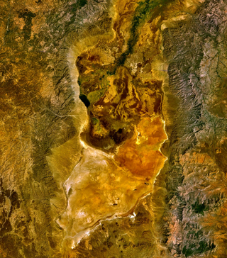
Lake Chew Bahir or Lake Istifanos, also called Stefanie, Basso Naebor and Chuwaha, is a lake in southern Ethiopia, located on the southwestern end of the Southern Nations, Nationalities and Peoples' Region, near the border with Oromia Region.
Spatsizi Plateau Wilderness Provincial Park is located in the northern portion of British Columbia, Canada, approximately 698, 659 hectares and encompasses the Spatsizi River and Gladys Lake Ecological Reserve. The park is a designated protected area that is intended for the conservation and research on caribou, grizzly bears, fish, and other wildlife species populations. Before the provincial park's establishment in 1975, the area was a historical hunting ground for local Indigenous communities like the Tahltan First Nations.It is the second largest provincial park in British Columbia.

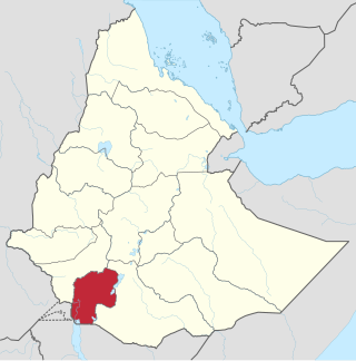
South Omo Zone is a zone in the Ethiopian South Ethiopia Regional State. South Omo is bordered on the south by Kenya, on the southwest by the South Sudan, on the west by Bench Maji, on the northwest by Keffa, on the north by Konta, Gamo Gofa and Basketo, on the northeast by Dirashe and Konso, and on the east by the Oromia Region. The administrative center of South Omo is Jinka.
Selamago is a woreda in the Southern Nations, Nationalities, and Peoples' Region of Ethiopia. Part of the Debub Omo Zone, Selamago is bordered on the south by Nyangatom, on the west and north by the Omo River which separates it from the Bench Maji, Keffa and Konta, on the northeast by the Gamo Gofa, on the east by the Basketo and Bako Gazer, and on the southeast by the Usno River which separates it from Bena Tsemay; the Mago River defines part of the boundary with Bako Gazer. The administrative center of Selamago is Hana.
Hamer is a woreda in Southern Nations, Nationalities, and Peoples' Region, Ethiopia. It is named after Hamer people who live in this woreda. Part of the Debub Omo Zone, Hamer is bordered to the south by Dasenech woreda, to the southwest by Kuraz, to the west by Nyangatom, to the north by Bena Tsemay, and to the east by the Oromia Region; the Weito River separates it from the Oromia Region. Hamer includes part of Lake Chew Bahir along its southeastern border. The administrative center is Dimeka; other towns include Turmi. Hamer was part of former Hamer Bena woreda. They wore the nations namely Hamer(dominant), Kara, and Arbore nations live together with respecting each other with tolerance.
Teltele is one of the Aanaas in the Oromia of Ethiopia. It is named after the administrative center, Teltele. Located in the southwest corner of the Borena Zone, Teltele is bordered on the southwest by Kenya, on the west and north by the Sagan River, the only river in this woreda, which separates it from the Southern Nations, Nationalities, and Peoples Region, on the northeast by Yabelo, and on the southeast by Dire.
The Weito River is a river in the Southern Nations, Nationalities, and Peoples' Region of Ethiopia. It rises in the Guge Mountains, flowing south into Lake Chew Bahir at latitude and longitude 4°49′58″N36°58′54″E.

Botswana's principal tourist attractions are its game reserves, with hunting and photographic safaris available. Other attractions include the Okavango Delta region, which during the rainy season is a maze of waterways, islands, and lakes. The tourism industry also helped to diversify Botswana's economy from traditional sources such as diamonds and beef and created 23,000 jobs in 2005.

The wildlife of South Sudan refers to the natural flora and fauna of South Sudan. South Sudan includes the Sudd, one of the world's largest wetlands. According to the American biologist and conservationist, J. Michael Fay, South Sudan "could present the biggest migration of large mammals on earth", while Wildlife Conservation Society (WCS) reports southeast Sudan has a migration of 1.3 million antelopes. The region has a low density human population, with approximately 7 million people spread over approximately 619,745 km2 (239,285 sq mi).
Hamer Bena was one of the 77 woredas in the Southern Nations, Nationalities, and Peoples' Region of Ethiopia. Part of the Debub Omo Zone, Hamer Bena was bordered on the south by Kenya, on the southwest by Kuraz, on the northwest by the Usno River which separates it from Selamago, on the north by Bako Gazer, on the northeast by the Konso special woreda, and on the east by the Oromia Region; the Weito River separated it from Konso and the Oromia Region and the Neri River defined part of the boundary with Bako Gazer. Hamer Bena included part of Lake Chew Bahir along its southeastern border. The administrative center was Dimeka; other towns in Hamer Bena included Arbore, Key Afer, and Turmi. Hamer Bena was separated for Hamer and Bena Tsemay woredas.
Vaseux-Bighorn National Wildlife Area is a National Wildlife Area in British Columbia, Canada, primarily set aside to protect winter rangeland for California bighorn sheep. In 1979, the Vaseux-Bighorn Wildlife Area was established in response to substantial reduction in wild animal populations in the area. Identified factors contributing to species decline at the time were high predator population, overharvesting of species, and illegal hunting. Land development, cattle raising, and lumbering also might have altered species populations. Under these conditions, the area was able to be classified as a Category IV area by the IUCN and is now used for wildlife habitat and conservation. Even with minimal anthropogenic use of the area, threats persist through invasive species. Recreational use is limited spatially and is only open to the public during the day.

White Lake Grasslands Protected Area is a conservation site located in the Regional District of Okanagan-Similkameen of British Columbia, Canada. It was established on April 18, 2001 by order-in-council under the Environment and Land Use Act to protect the semi-arid grassland and pine forest ecosystem west of Vaseux Lake. The region spans from shoreline to mountain top, providing essential living areas for various red and blue-listed species, plants, and plant groups in British Columbia.
Gladys Lake Ecological Reserve is an ecological reserve located in the Eaglenest Range of the Spatsizi Plateau in north-central British Columbia, Canada. It was established in 1975 under the Ecological Reserves Act to facilitate scientific research of the region's alpine-subalpine ecosystems while discouraging outdoor recreation use. The reserve protects 44,098 hectares of pristine wilderness and is the largest ecological reserve in British Columbia.

Borana National Park, located in the Borana Zone of the Oromia Regional State in Ethiopia, is a renowned wildlife sanctuary known for its rich biodiversity and conservation efforts. This park has a significant history of stewardship and has seen various administrative changes over the years.
Mille-Serdo Wildlife Reserve is a protected area in Ethiopia. It is located in Afar Region of Ethiopia. The reserve protects a portion of the Awash River and the surrounding desert.
