Awash National Park | |
---|---|
Location | Ethiopia |
Nearest city | Adama (145 KM) |
Coordinates | 9°08′33″N40°0′0.00″E / 9.14250°N 40.0000000°E |
Area | 850 km2 (330 sq mi) |
Established | 1966 |
Awash National Park is a national park in Ethiopia. Located at the border of Oromia state and Afar state, the park covers an area of 827 square kilometers, most of it lies at an altitude of 900 meters. Spanning across the southern tip of the Afar Region and the northeastern corner of the East Shewa Zone of Oromia, this park is 225 kilometers east of Addis Ababa (and a few kilometers west of Awash and east of Metehara).
The park is best known for its rich biodiversity and rural landscapes. [1]
the region is subject to a bimodal rainfall pattern a rainy season followed by a dominant dry season which can last up to 10 months. [2]
The Awash National Park was established in 1966, although the act authorizing its existence was not completely passed for another three years. In establishing this park, as well as the Metehara Sugar Plantation to the south, the livelihoods of the indigenous Karayyu Oromo people have been endangered — an effect that is contrary to the Ethiopian government's original intention of these establishments serving to benefit the local population.
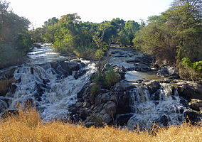
Along with its southern boundary along the Awash River, Awash National Park covers 850 square kilometers of acacia woodland and grassland. The Addis Ababa – Dire Dawa highway passes through this park, separating the Illala Saha Plains to the south from the Kudu Valley to the north. Further south of the park, the Awash River gorge has amazing waterfalls such as the Awash Falls. In the upper Kudu Valley at Filwoha are hot springs amid groves of palm trees thrives at the river bed. The park is home to Mount Fentale, a dormant stratovolcano which is located in the western area of Awash National Park at an altitude of 2,007 meters above sea level. [3]
Awash national park's vegetation is classified into four ecosystems: arid Acacia woodlands, thorned bushlands, grazing savannas, and diverse riverine wetlands. [4] Doum palm trees and Desert date trees are found scattered across the Filwoha and Doha sites of Awash National Park which provides a suitable niche for all mammalian, avian, and reptilian species. [5]
Awash national park is home to more than 81 species of mammals and 43 species of reptiles. Beisa oryxes are common here for their populations. Other species that live within these park ecoregions include Aardvarks, Aardwolves, caracals, servals, hippopotamuses, Crested porcupines, Spotted hyenas, Striped hyenas, lions, leopards, cheetahs, Soemmerring's gazelles, Defassa waterbucks, Spotted-necked otters, Rock hyraxes, klipspringers, Salt's dik-diks, lesser kudus, greater kudus, and warthogs. Swayne's hartebeests were translocated to Awash national park for repopulation but their presence is left uncertain due to their population decline and environmental change. Primates of Awash National park such as Olive baboons, guerezas, grivets, and hamadryas baboons are abundantly common throughout the park's ecosystems. [6] [7] [8] [9] Animals such as elephants, rhinos, zebras, and Cape buffalo were once presented since the 1960s but were now extirpated because of hunting, population decline, and habitat loss.
Nile crocodiles are found in Awash river valleys and gorges while Rock pythons are found in riverine forests and hot spring oases. Leopard tortoises are rarely seen on savanna grassland and dry thickets for feeding, which is the only tortoise species listed here. Venomous snakes, such as Saw-scaled viper (Echis carinatus pyramidum), Puff adder (Bitis arietans somalica), Rhombic night-adder (Causus rhombeatus), Black mamba (Dendroaspis polylepis antinori), Eastern pallid spitting cobra (Naja mossambica pallida), and Black-necked spitting cobra (Naja nigricollis), are frequently found within the park ecosystems that are considered dangerous for encountering them. Other reptile species such as geckos, skinks, agamas, snakes, and monitors are frequently diverse in arid scrublands and riverine wetlands. [10]
The park also contains 453 species of native birds which includes Somali ostriches, Lappet-faced vultures, White-bellied go-away-birds, Crested francolins, White-headed buffalo weavers, Chestnut-headed sparrow-larks, Northern carmine bee-eaters, Kori bustards, Abyssinian rollers, Abyssinian ground hornbills, Red-billed hornbill, and Brown snake-eagles. Wattled Ibis (Bostrychia carunculata), Black-winged lovebird (Agapornis taranta), Banded barbet (Lybiusun datus), Yellow-throated seedeater (Crithagra flavigula), Abyssinian woodpecker (Dendropicos abyssinicus), White-billed starling (Onychognathus albirostris), and Thick-billed raven (Corvus crassirostris) are 7 endemic species that are compromised within the park's biodiversity. [11] [12] [13]
The hamadryas baboon is a species of baboon within the Old World monkey family. It is the northernmost of all the baboons, being native to the Horn of Africa and the southwestern region of the Arabian Peninsula. These regions provide habitats with the advantage for this species of fewer natural predators than central or southern Africa where other baboons reside. The hamadryas baboon was a sacred animal to the ancient Egyptians and appears in various roles in ancient Egyptian religion, hence its alternative name of 'sacred baboon'.
The Awash is a major river of Ethiopia. Its course is entirely contained within the boundaries of Ethiopia and empties into a chain of interconnected lakes that begin with Lake Gargori and end with Lake Abbe on the border with Djibouti, some 100 kilometres from the head of the Gulf of Tadjoura. It is the principal stream of an endorheic drainage basin covering parts of the Amhara, Oromia and Somali Regions, as well as the southern half of the Afar Region.
Simien Mountains National Park is the largest national park in Ethiopia. Located in the North Gondar Zone of the Amhara Region, its territory covers the highest parts of the Simien Mountains and includes Ras Dashan, the highest point in Ethiopia.
The Bale Mountains are mountain ranges in the Oromia Region of southeast Ethiopia, south of the Awash River, part of the Ethiopian Highlands. They include Tullu Demtu, the second-highest mountain in Ethiopia, and Mount Batu. The Weyib River, a tributary of the Jubba River, rises in these mountains east of Goba. The Bale Mountains National Park covers 2,200 square kilometers of these mountains. The park's main attractions are the wild alpine scenery and the relative ease with which visitors can see unique birds and mammals.
Abijatta-Shalla National Park is a national park in Ethiopia. It is located in the Oromia Region and the Ethiopian Highlands region, 200 kilometers south of Addis Ababa, and east of the Batu–Shashamane highway.
Yangudi Rassa National Park is a national park in Ethiopia located in Afar Region.
Omo National Park is a national park in Ethiopia founded in 1980. Located in the Southern Nations, Nationalities, and Peoples' Region on the west bank of the Omo River, the park covers approximately 4,068 square kilometers, about 870 kilometers southwest of Addis Ababa; across the Omo is the Mago National Park and the Tama Wildlife Reserve. Although an airstrip was recently built near the park headquarters on the Mui River, this park is not easily reachable; the Lonely Planet guide Ethiopia and Eritrea describes Omo National Park as "Ethiopia's most remote park."
The Ethiopian Highlands is a rugged mass of mountains in Ethiopia in Northeast Africa. It forms the largest continuous area of its elevation in the continent, with little of its surface falling below 1,500 m (4,900 ft), while the summits reach heights of up to 4,550 m (14,930 ft). It is sometimes called the "Roof of Africa" due to its height and large area. It is the only country in the region with such a high elevated surface. This elevated surface is bisected diagonally by the Great East African Rift System which extends from Syria to Mozambique across the East African Lakes. Most of the Ethiopian Highlands are part of central and northern Ethiopia, and its northernmost portion reaches into Eritrea.
Fentale is one of the districts in the Oromia of Ethiopia. Part of the East Shewa Zone located in the Great Rift Valley, Fentale is bordered on the southeast by the Arsi Zone, on the southwest by Boset, on the northwest by the Amhara Region, and on the northeast by the Afar Region. The administrative center of Fentale is Metehara; other towns include Haroo Adii.
Nannawa Adama is a woreda in Oromia Region, Ethiopia. Part of the East Shewa Zone located in the Great Rift Valley, Adama Zuria is bordered on the south by the Arsi Zone, on the southwest by Koka Reservoir which separates it from Dugda Bora, on the west by Lome, on the north by the Amhara Region, and on the east by Boset; the Awash River, the only important river in this woreda, defines the woreda boundaries on the east and south. Other towns in this woreda include Awash Melkasa, Shewa Alemtena, Sire Robi, Sodere and Wenji Gefersa.
The Babile Elephant Sanctuary is a protected area and wildlife sanctuary in eastern Ethiopia. It is located in Babille district, East Hararghe Zone of Oromia Region, which lies 560 km east of Addis Ababa and 40 km south of Harar.
Fentale is a stratovolcano located in Awash National Park which was found in the Oromia Region, Ethiopia. It is the highest point of Fentale woreda.
Abaya is a woreda in the Oromia Region, Ethiopia. It is part of former Gelana Abaya woreda what was divided for Abaya and Gelana woredas. Part of the Borena Zone, Gelana Abaya was bordered on the south by Hagere Mariam, and on the west, north and east by the Southern Nations, Nationalities, and Peoples Region (SNNPR). Lake Abaya, on the western border, is divided between this woreda and the SNNPR. However, the Guji Oromo who live in Nechisar National Park are claimed to be administratively part of this woreda, in a kebele called "Irgansaa".
Yabelo Wildlife Sanctuary is a protected area and wildlife sanctuary in southern Ethiopia. It is located in the Borena Zone of the Oromia Region west of the town of Yabelo, having an area of 2,500 square kilometers and elevations ranging from 1430 to 2000 meters above sea level. The wildlife sanctuary borders on Borana National Park to the south.
Maze National Park is a national park in the Southern Nations, Nationalities, and People's Region of Ethiopia. It is located 460 km southwest of Addis Ababa and 248 km from Hawassa. It covers 210 square kilometers or 2020 hectare. Maze was founded in 2005, and is managed by the Ethiopian Wildlife Conservation Authority.
The Kafa Biosphere Reserve is located in the Kafa Zone of Ethiopia approximately 460 km southwest of Addis Ababa. The Bonga National Forest Priority Area partly forms the southern boundary of the Biosphere Reserve, whilst the eastern boundary follows the Adiyo Woreda with the Gojeb River and Gewata-Yeba (Boginda) National Forest Priority Area forming the northern boundary.
Alitash National Park, also called Alatish or Alatash National Park, is a national park in North Gondar Zone, Amhara Region, Ethiopia. It is adjacent to Sudan's Dinder National Park. The national park was founded in 2006. It derives its name from the Alatash River that has its source in the park and flows to Sudan.
Arsi Mountains National Park is a national park in Arsi Zone of Oromia Region in Ethiopia. It protects a portion of the Ethiopian Highlands, and includes montane forests, subalpine heath, and alpine grasslands and shrublands. The park was designated in 2011, and covers an area of 10876 km2.
Borana National Park is a wildlife sanctuary located in the Borana Zone of the Oromia Regional State in Ethiopia.
Geography of Oromia Region, the largest regional state of Ethiopia, is highly diverse. Occupying 353,690 square kilometers, it is bordered by Somalia, to the east, Afar Region to the north, Djibouti to north-east, Kenya, to the south, Amhara Region to the north, Benishangul-Gumuz to the north-west, Sudan to the north-west, Gambela to the west, and South Sudan to the west. The region is situated between 2° and 12°N, 34° and 44°E with varied landscape ranging from rugged mountain ranges in the center and the north, to flat grassland to the south-east.