A bascule bridge is a moveable bridge with a counterweight that continuously balances a span, or leaf, throughout its upward swing to provide clearance for boat traffic. It may be single- or double-leafed.

The Fremont Bridge is a double-leaf bascule bridge that spans the Fremont Cut in Seattle, Washington. The bridge, which connects Fremont Avenue North and 4th Avenue North, connects the neighborhoods of Fremont and Queen Anne.

The Montlake Bridge is a double-leaf bascule bridge that carries State Route 513 over Seattle's Montlake Cut—part of the Lake Washington Ship Canal—connecting Montlake and the University District.

The Broadway Bridge is a Rall-type bascule bridge spanning the Willamette River in Portland, Oregon, United States, built in 1913. It was Portland's first bascule bridge, and it continues to hold the distinction of being the longest span of its bascule design type in the world. It was added to the National Register of Historic Places in November 2012.

The BNSF Railway Bridge 5.1, also known as the St. Johns Railroad Bridge or the Willamette River Railroad Bridge, is a through truss railway bridge with a vertical lift that spans the Willamette River in Portland, Oregon, United States. Built by the Spokane, Portland and Seattle Railway (SP&S) and completed in 1908, it was originally a swing-span bridge, and its swing-span section was the longest in the world at the time. However, 81 years later the main span was converted from a swing-type to a vertical-lift type, in order to widen the navigation channel. The lift span is one of the highest and longest in the world. The bridge consists of five sections, with the two sections closest to the bank on each side fixed.

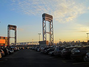
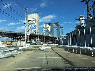
The Maurice J. Tobin Memorial Bridge is a cantilever truss bridge that spans more than two miles (3.2 km) from Boston to Chelsea over the Mystic River in Massachusetts, United States. The bridge is the largest in New England. It is operated by the Massachusetts Department of Transportation and carries U.S. Route 1. It was built between 1948 and 1950 and opened to traffic on February 2, 1950, replacing the former Chelsea Bridge. The 36-foot (11 m)-wide roadway has three lanes of traffic on each of the two levels with northbound traffic on the lower level and southbound traffic on the upper level.

A moveable bridge, or movable bridge, is a bridge that moves to allow passage for boats or barges. In American English, the term is synonymous with drawbridge, and the latter is the common term, but drawbridge can be limited to the narrower, historical definition used in some other forms of English, in which drawbridge refers to only a specific type of moveable bridge often found in castles.
The Charles River Dam Bridge, officially the Craigie Bridge, also called Craigie's Bridge or the Canal Bridge, is a six-lane bascule bridge across the Charles River in the West End neighborhood of Boston. The bridge, maintained by the Massachusetts Department of Conservation and Recreation, carries Massachusetts Route 28 next to the Green Line's Lechmere Viaduct. The Museum of Science is located on the dam and nearby piers. Charles River Dam Road connects Leverett Circle in the West End to East Cambridge, but most of the road is fixed, and the asymmetrically sited drawbridge is a short span entirely on the Boston side of the river.
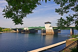
The Prescott Drawbridge, also called the Point Douglas Drawbridge, is a steel girder bridge with a double-leaf bascule drawbridge section. The roadbed of the drawbridge span is a steel grate. The bridge carries U.S. 10 across the St. Croix River and connects Prescott, Wisconsin, with the Point Douglas park area of Denmark Township, Minnesota. This is the only highway drawbridge in the Minneapolis–Saint Paul area with active traffic. It was completed in 1990 and replaced a rare regional example of a Waddell & Harrington vertical-lift bridge completed in 1922 that operated as a toll bridge from 1923 to 1946. The environmental impact statement, published in 1979, considered a higher level fixed bridge at this location.

The Newark Bay Bridge of the Central Railroad of New Jersey (CNJ) was a railroad bridge in New Jersey that connected Elizabethport and Bayonne at the southern end of Newark Bay. Its third and final incarnation was a four-track vertical-lift design that opened in 1926, replacing a bascule bridge from 1904 which superseded the original swing bridge from 1887. The bridge served the main line of the CNJ, carrying daily interstate trains as well as commuter trains.
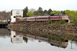
The Newburyport/Rockport Line is a branch of the MBTA Commuter Rail system, running northeast from downtown Boston, Massachusetts towards Cape Ann and the Merrimack Valley, serving the North Shore. The first leg, operating via the Eastern Route of the former Boston and Maine Railroad, serves Chelsea, Lynn, Swampscott, Salem, and Beverly. From there, a northern branch continues via the Eastern Route to serve Hamilton, Ipswich, Rowley, and Newburyport, while other trains operate east from Beverly via the Gloucester Branch, serving Manchester, Gloucester, and Rockport. A bicycle coach is offered on the Rockport branch during the summer. With over 11,000 daily riders in October 2022, the line is the second-busiest on the system.

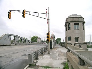
The Lafayette Avenue Bridge, formerly listed on the National Register of Historic Places as the Bay City Bascule Bridge, is the name given to two separate bridges located in Bay City, Michigan. The bridges carry M-13 and M-84 over the Saginaw River. They are maintained by the Michigan Department of Transportation, and the bascule portion is currently the oldest of Bay City's four modern drawbridges. It was listed on the National Register of Historic Places on November 30, 1999, but was removed from the Register in 2015.

The Charles River Bridge, referred to by the MBTA as Draw One, is a pair of railroad single-leaf, through-truss, rolling bascule bridges across the Charles River in Boston, Massachusetts that connects North Station to MBTA Commuter Rail lines serving areas to the north.
The West Jefferson Avenue–Rouge River Bridge is a historic double-leaf bascule bridge in Wayne County, Michigan, at the border of the cities of Detroit and River Rouge. The bridge carries Jefferson Avenue, a major thoroughfare in Southwest Detroit, over the River Rouge, an important inland route for lake freighters. The bridge was built in 1922, and was listed on the National Register of Historic Places in 2000.

The Cheboygan Bascule Bridge, also known as the State Street Bridge, is a double-leaf bascule bridge in Cheboygan, Michigan, carrying U.S. Highway 23 across the Cheboygan River. Built in 1940, it was the last bascule bridge constructed in the state of Michigan prior to the end of World War II. It replaced an aging swing bridge built in 1877. The bridge is listed on the National Register of Historic Places.

The Belleville Turnpike Bridge is a vehicular moveable bridge spanning the Passaic River in northeastern New Jersey 8.9 miles (14.3 km) from its river mouth at Newark Bay. Also known as Rutgers Street Bridge and Route 7 Bridge, it is the fourth fixed crossing to be built at the location, today the tripoint of the municipal and county lines of Belleville in Essex, Kearny in Hudson, and North Arlington in Bergen. Commissioned by the New Jersey Department of Transportation, which owns and operates it, the vertical lift bridge opened in 2002.
The Fore River Bridge spans the Weymouth Fore River between Quincy and Weymouth, Massachusetts. The total length of the bridge including the approaches is 2,216 feet (675 m).

Eighth Street Bridge is a road bridge over the Passaic River in northeastern New Jersey, United States. It connects the City of Passaic in Passaic County with the Borough of Wallington in Bergen County and is jointly owned by both counties. The bridge connects Eighth Street in Passaic with County Route 507 in Wallington.
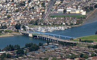
The San Leandro Bay Bridge, better known as the Bay Farm Island Bridge, is a single-leaf bascule drawbridge spanning the San Leandro Channel, the inlet of San Leandro Bay within the San Francisco Bay Area, California, United States. It carries California State Route 61 and links the main island of Alameda with Bay Farm Island within the city of Alameda. The present bridge was completed in 1953; it is paralleled by a second bridge devoted to pedestrian and bicycle traffic, the Bay Farm Island Bicycle Bridge.

The Dorset Avenue Bridge is a vehicular bridge in Ventnor City, Atlantic County, New Jersey, south of in Atlantic City. The double-leaf Strauss trunnion bascule drawbridge spans the Intracoastal Waterway (ICW) Inside Thorofare and carries CR 629 in Ventnor Heights and St Leonard's Tract on Absecon Island.