Related Research Articles

The Smoky Hill River is a 575-mile (925 km) river in the central Great Plains of North America, running through Colorado and Kansas.

The Smoky Hills are an upland region of hills in the central Great Plains of North America. They are located in the Midwestern United States, encompassing north-central Kansas and a small portion of south-central Nebraska.

Erasmus Haworth (1855–1932) was an American geologist.

Cisco Oil Field is an oil field located in Grand County, Utah. The field was discovered in 1924 in the now abandoned town of Cisco, Utah. It is one of the oldest oil fields in the state of Utah. The field has been developed intermittently since then with the discovery of several small accumulations of oil. The field lies along a larger feature known as the Uncompahgre Uplift which is a boundary between Paradox Basin, the Uintah Basin and the Piceance Basin.

The Dakota is a sedimentary geologic unit name of formation and group rank in Midwestern North America. The Dakota units are generally composed of sandstones, mudstones, clays, and shales deposited in the Mid-Cretaceous opening of the Western Interior Seaway. The usage of the name Dakota for this particular Albian-Cenomanian strata is exceptionally widespread; from British Columbia and Alberta to Montana and Wisconsin to Colorado and Kansas to Utah and Arizona. It is famous for producing massive colorful rock formations in the Rocky Mountains and the Great Plains of the United States, and for preserving both dinosaur footprints and early deciduous tree leaves.

The Piceance Basin is a geologic structural basin in northwestern Colorado, in the United States. It includes geologic formations from Cambrian to Holocene in age, but the thickest section is made up of rocks from the Cretaceous Period. The basin contains reserves of coal, natural gas, and oil shale. The name likely derives from the Shoshoni word /piasonittsi/ meaning “tall grass”.
Smoky Hill City is a ghost town in Lookout Township, Ellis County, Kansas, United States. It lies approximately 12 miles (19 km) southwest of Hays.
Blue Valley is part of the Fremont River drainage extending from just east of the Caineville Reef to Hanksville, Utah. This stretch of the Fremont River is located approximately 15 miles east of Capitol Reef National Park. It is called Blue Valley because of the blue color of the Mancos Shale that is the dominant geological formation of the Fremont river valley at that elevation. Blue Valley is the location of several ghost towns including Caineville, Giles, and Elephant. First settled by Americans during the late 1880s as farming and ranching communities, the settlements were all abandoned in 1910 due to flooding of the Fremont River which washed away many farms, destroyed the irrigation systems, and lowered the elevation of the river.

The Niobrara Formation, also called the Niobrara Chalk, is a geologic formation in North America that was deposited between 87 and 82 million years ago during the Coniacian, Santonian, and Campanian stages of the Late Cretaceous. It is composed of two structural units, the Smoky Hill Chalk Member overlying the Fort Hays Limestone Member. The chalk formed from the accumulation of coccoliths from microorganisms living in what was once the Western Interior Seaway, an inland sea that divided the continent of North America during much of the Cretaceous. It underlies much of the Great Plains of the US and Canada. Evidence of vertebrate life is common throughout the formation and includes specimens of plesiosaurs, mosasaurs, pterosaurs, and several primitive aquatic birds. The type locality for the Niobrara Chalk is the Niobrara River in Knox County in northeastern Nebraska. The formation gives its name to the Niobrara cycle of the Western Interior Seaway.
Colorado is a geologic name applied to certain rocks of Cretaceous age in the North America, particularly in the western Great Plains. This name was originally applied to classify a group of specific marine formations of shale and chalk known for their importance in Eastern Colorado. The surface outcrop of this group produces distinctive landforms bordering the Great Plains and it is a significant feature of the subsurface of the Denver Basin and the Western Canadian Sedimentary Basin. These formations record important sequences of the Western Interior Seaway. As the geology of this seaway was studied, this name came to be used in states beyond Colorado but later was replaced in several of these states with more localized names.

The Carlile Shale is a Turonian age Upper/Late Cretaceous series shale geologic formation in the central-western United States, including in the Great Plains region of Colorado, Kansas, Nebraska, New Mexico, North Dakota, South Dakota, and Wyoming.

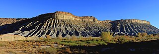
The Mancos Shale or Mancos Group is a Late Cretaceous geologic formation of the Western United States.

Yocemento is an unincorporated community in Big Creek Township, Ellis County, Kansas, United States. The settlement lies across the banks of Big Creek against the base of bluffs capped by massive limestone blocks, in which lies the 20th-century origin of the community.

The Graneros Shale is a geologic formation in the United States identified in the Great Plains as well as New Mexico that dates to the Cenomanian Age of the Cretaceous Period. It is defined as the finely sandy argillaceous or clayey near-shore/marginal-marine shale that lies above the older, non-marine Dakota sand and mud, but below the younger, chalky open-marine shale of the Greenhorn. This definition was made in Colorado by G. K. Gilbert and has been adopted in other states that use Gilbert's division of the Benton's shales into Carlile, Greenhorn, and Graneros. These states include Kansas, Texas, Oklahoma, Nebraska, and New Mexico as well as corners of Minnesota and Iowa. North Dakota, South Dakota, Wyoming, and Montana have somewhat different usages — in particular, north and west of the Black Hills, the same rock and fossil layer is named Belle Fourche Shale.

The Greenhorn Limestone or Greenhorn Formation is a geologic formation in the Great Plains Region of the United States, dating to the Cenomanian and Turonian ages of the Late Cretaceous period. The formation gives its name to the Greenhorn cycle of the Western Interior Seaway.

The Benton Shale is a geologic formation name historically used in Montana, Wyoming, North Dakota, South Dakota, Colorado, Kansas, and Nebraska. In the "mile high" plains in the center of the continent, the named layers preserve marine fossils from the Late Cretaceous Period. The term Benton Limestone has also been used to refer to the chalky portions of the strata, especially the beds of the strata presently classified as Greenhorn Limestone, particularly the Fencepost limestone.

Turkville is a ghost town in Buckeye Township, Ellis County, Kansas, United States.

Isaac M. Yost, commonly I. M. Yost, or "Ike", was a miller and frontier industrialist who led the development of flour milling in the settlement of Hays City, Kansas. Even though he was the leading miller in Hays for decades, he was particularly remembered there for co-founding the short-lived United States Portland Cement Company and the associated townsite of Yocemento.

Juana Lopez refers to both the uppermost member of the Carlile Shale formation and to the environment that caused it to form. The Juana Lopez Member is calcareous sandstone dated to the Turonian age of the Upper Cretaceous and is exposed in the southern and western Colorado, northern and central New Mexico, and northeastern Utah. The unit has been described as "the most enigmatic" member of the Carlile Shale.

Fencepost limestone, Post Rock limestone, or Stone Post is a stone bed in the Great Plains notable for its historic use as fencing and construction material in north-central Kansas resulting in unique cultural expression. The source of this stone is the topmost layer of the Greenhorn Limestone formation. It is a regional marker bed as well as a valued construction material of the late 19th and early 20th centuries in Kansas. This stone was very suitable for early construction in treeless settlements and it adds a notable rust orange tint to the region's many historic stone buildings. But the most famous use is seen in the countless miles of stone posts lining country roads and highways. This status gives rise to such regional appellations as Stone Post Country, Post Rock Scenic Byway, and The Post Rock Capital of Kansas. This rustic quality finds Fencepost limestone still used in Kansas landscaping today.
References
- 1 2 "Ellis County, Kansas; City of Chetolah". KSGenWeb. Archived from the original on 6 June 2013. Retrieved 11 June 2014.
- ↑ N. W. Bass. Geologic Investigations in Western Kansas with special reference to oil and gas possibilities, Bulletin 11. p. Part I--The Geology of Ellis County, Kansas. Retrieved November 28, 2020.
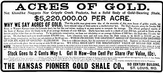
In 1903 a well was drilled near the center of sec. 10, T. 15 S., R. 20 W. (Darton, 1905), in search of gas for use in mills that were being erected for the extraction of gold from the Carlile shale (Lindgren, 1902)
- ↑ Rex C. Buchanan. "'To bring together, correlate, and preserve'--a history of the Kansas Geological Survey, 1864-1989" . Retrieved November 28, 2020.
I might have learned that Erasmus Haworth had been the first state geologist and director of the present Geological Survey and that he had mapped the structure on which lies the most productive oil field in Kansas, the El Dorado of Butler County.
- ↑ Dan Plazak (2007). "The imaginary gold mines of Kansas" (PDF). Mining History Journal. 14: 11–22. Retrieved November 28, 2020.
{{cite journal}}: CS1 maint: numeric names: authors list (link)
