
The Elan Valley Reservoirs are a chain of man-made lakes created from damming the Elan and Claerwen rivers within the Elan Valley in Mid Wales. The reservoirs, which were built by the Birmingham Corporation Water Department, provide clean drinking water for Birmingham in the West Midlands of England. The five lakes are known as the Claerwen, Craig-goch, Pen-y-garreg, Garreg-ddu, and Caban-coch.

Thirlmere is a reservoir in the Borough of Allerdale in Cumbria and the English Lake District. The Helvellyn ridge lies to the east of Thirlmere. To the west of Thirlmere are a number of fells; for instance, Armboth Fell and Raven Crag both of which give views of the lake and of Helvellyn beyond.

Chew Valley Lake is a reservoir in Chew Stoke, Chew Valley, Somerset, England. It is the fifth-largest artificial lake in the United Kingdom, with an area of 1,200 acres (4.9 km2). The lake, created in the early 1950s, was opened by Queen Elizabeth II in 1956. It provides much of the drinking water for the city of Bristol and surrounding area, taking its supply from the Mendip Hills. Some of the lake water is used to maintain the flow in the River Chew.

Greenfield is a village in the civil parish of Saddleworth in the Metropolitan Borough of Oldham, in Greater Manchester, England. It is 4 miles (6.4 km) east of Oldham and 13 miles (21 km) north-east of Manchester. It is located in a broad rural area at the southern edge of the South Pennines; Dovestone Reservoir, Chew Reservoir and Greenfield Reservoir lie to the east of the village in the Peak District National Park.
Dove Stone Reservoir lies at the convergence of the valleys of the Greenfield and Chew Brooks above the village of Greenfield, on Saddleworth Moor in Greater Manchester, England. The reservoir is on the western edge of the Peak District National Park. It supplies drinking water to the surrounding area and is a tourist attraction, providing several walks amongst picturesque landscapes.

Saddleworth Moor is a moorland in North West England. Reaching more than 1,312 feet (400 m) above sea level, it is in the Dark Peak area of the Peak District National Park. It is crossed by the A635 road and the Pennine Way passes to its eastern side.

Bristol Water is a British water company which supplies 266 million litres of drinking water daily to over 1.2 million customers in a 2,600 km2 (1,000 sq mi) area centred on Bristol, England. It is regulated under the Water Industry Act 1991. Sewerage services in the Bristol area are provided by Wessex Water.

Chew Magna Reservoir is a 5-acre (2 ha) reservoir on the western outskirts of the village of Chew Magna, Somerset, England. It lies just north of the B3130 Winford Road.

The West Pennine Moors is an area of the Pennines covering approximately 90 square miles (230 km2) of moorland and reservoirs in Lancashire and Greater Manchester, England. It is a Site of Special Scientific Interest.

Chew Valley in Saddleworth, Greater Manchester, England, follows the course of Chew Brook on the western slopes of Black Chew Head to where it joins the River Tame at Greenfield, east of Manchester. Part of the higher fringes of the valley towards the peak of Black Chew Head lie across the boundary in Derbyshire. The eastern part of the valley including the reservoirs of Dovestone and Chew are within the north western extremity of the Peak District National Park.

The Longdendale Chain is a sequence of six reservoirs on the River Etherow in the Longdendale Valley, in northern Derbyshire. They were constructed between 1848 and 1884 to a design by John Frederick Bateman to supply the growing population of Manchester and Salford with fresh water.

Black Chew Head in Saddleworth in the Metropolitan Borough of Oldham is the highest point or county top of Greater Manchester in northern England. It stands on moorland on the edge of the Peak District at a height of 542 m (1,778 ft) above sea level, close to the border with the High Peak district of Derbyshire.
Mardale is a glacial valley in the Lake District, in northern England. The valley used to have a hamlet at its head, called Mardale Green, but this village was submerged in the late 1930s when the water level of the valley's lake, Haweswater, was raised to form Haweswater Reservoir by Manchester Corporation.
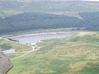
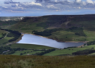
Yeoman Hey Reservoir is a reservoir in the English Peak District. On its margin is a commemorative stone laid by the King of Tonga in 1981. The reservoir is within the boundaries of Greater Manchester but was formerly in the West Riding of Yorkshire. It is one of three reservoirs in the same valley: above it is Greenfield Reservoir, and adjacent to and below it is Dovestone Reservoir. The reservoirs lie to the south of the A635 road across Saddleworth Moor. To the west, below the reservoirs, is the village of Greenfield.
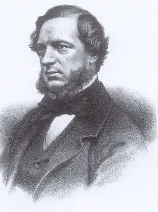
John Frederick La Trobe Bateman was an English civil engineer whose work formed the basis of the modern United Kingdom water supply industry. For more than 50 years from 1835 he designed and constructed reservoirs and waterworks. His largest project was the Longdendale Chain system that has supplied Manchester with much of its water since the 19th century. The construction of what was in its day the largest chain of reservoirs in the world began in 1848 and was completed in 1877. Bateman became "the greatest dam-builder of his generation".
The Grand Contour Canal in England and Wales was intended to enhance and upgrade the British canal system, but was never built. This canal was proposed in 1943, and again ten years later, by J F Pownall. Pownall observed that there was a natural 'contour' down the spine of England, around the 300 ft level that connected several of the most populated areas. He put forward the idea that this contour could be used to define the course of a large European sized canal which contained no locks except at its entry and exit points. It would also serve as a water grid capable of distributing domestic water supply around England as need arises.

Greenfield Valley is a river valley through Saddleworth Moor in England's Peak District National Park. Historically this area of the South Pennines was part of Yorkshire but since 1974 it has been within the eastern edge of the county of Greater Manchester.

