
Mahakali was one of the fourteen zones located in the Far-Western Development Region of Nepal, covering an area of 6,205 km2 in the most western part of the country. It stretches along Nepal's far western border with India, marked by the Kali River or Mahakali River.
Baitadi District, historical name “Bairath” (बैराथ), a part of Sudurpashchim Province, is one of the 77 districts of Nepal. It is a Hill district. Baitadi, with Dasharathchand as its headquarters, covers an area of 1,519 km2 (586 sq mi) and has a population of 250,898 according to the census (2011). The Baitadi district entails 56 village development councils (VDCs) and two municipality. Baitadi falls into the farthest western regional district of Nepal touching Jhulaghat, India, Nepal's neighboring country, to its border.

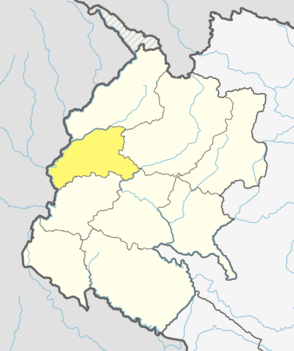
Darchula District (Nepali: दार्चुला जिल्ला pronounced [ˈdaɾt͡sula], a part of Sudurpashchim Province, is one of the nine districts of province and one of seventy-seven districts of Nepal. The district, with Khalanga as its district headquarters, covers an area of 2,322 km2 and has a population of 133,274. Darchula Lies in the west-north corner of the country.

Doti District, part of Sudurpashchim Province, is one of the 77 districts of Nepal. This district, with Silgadhi as its headquarters, covers an area of 2,025 square kilometres (782 sq mi) with a population of 207,066 in 2001 and increasing marginally to 211,746 in 2011.

Palpa District (Nepali: पाल्पा जिल्लाListen , a part of Lumbini Province, is one of the seventy-seven districts of Nepal, a landlocked country of South Asia. The district, with Tansen Municipality as its headquarters, covers an area of 1,373 km2 and has a population of 261,180.

Rasuwa District(Nepali: रसुवा जिल्लाListen is one of 13 districts of Bagmati Province and one of seventy-seven districts of Nepal. The district, with Dhunche as its district headquarters, covers an area of 1,544 km2 and has a population of 43,300. As per census 2011 total households in Rasuwa district is 9,778. It is the smallest district by area, among 16 districts in the Himalaya region of Nepal.

Bhimdatta, is a municipality in Kanchanpur District of Sudurpashchim Pradesh, Nepal. The city and the municipality were named Mahendranagar in the honour of late king Mahendra of Nepal. After becoming a republic in 2008, the Mahendranagar municipality name was changed to Bhimdatta municipality in honour of the revolutionary farmer leader Bhimdatta Panta. It is surrounded by Bedkot Municipality in the east, Dadeldhura District in the north, Shuklaphanta National Park in the south and Uttarakhand, India in the west.

A Village Development Committee (VDC) in Nepal was the lower administrative part of its Ministry of Federal Affairs and Local Development. Each district had several VDCs, similar to municipalities but with greater public-government interaction and administration. There were 3,157 village development committees in Nepal. Each VDC was further divided into several wards depending on the population of the district, the average being nine wards.limikot is the most popular place .there was a big pond this was made by (shankar) that like take a name of shankarpokhari.

Melamchi is a municipality in Sindhupalchok District in the Bagmati Zone of central Nepal. At the time of the 1991 Nepal census it had a population of 3936 and had 710 houses in the village.

The Far-Western Development Region was one of Nepal's five development regions. It was located at the western end of the country and had its headquarters in Dipayal.
Tokha Chandeshwari is a village and former Village Development Committee that is now part of Tokha Municipality in Kathmandu District in Province No. 3 of central Nepal. At the time of the 2011 Nepal census it had a population of 3961. Tokha Chandeshwari now is part of Tokha municipality.
Hariwan Municipality is one of the new municipalities declared by the Government of Nepal on May 18, 2014. It is located in Sarlahi District Janakpur zone, Nepal. It is formed by the joining of four contemporary Village development committees (VDCs) namely Atrouli, Sasapur, Ghurkauli and Harion VDCs covering an area of 88.1 km2. It has been divided into 11 wards with an administration center in Harion Bazar. According to Nepal Population Census 2011, the municipality has a total population of 42,783.
Lalbandi is a Municipality in Sarlahi District in the Janakpur Zone of south-eastern Nepal. The municipality was established on 18 May 2014 by merging the existing Parwanipur VDC, Netragung vdc, Jabdi, Lalbandi and Pattharkot VDCs. At the time of the 2011 Nepal Census it had a population of 59,395 people living in 3295 individual households. There are 17 wards in this municipality. It is the largest municipality in Sarlahi district. The office of this municipality is in ward no.6 Located in the Lalbandi. Lalbandi Bazar, located on the East West Mahendra highway, is one of the main trading areas within the municipal area. Bordering East Ishwarpur Municipality, West Hariwan and Haripur Municipality, North Sindhuli District and bordering Haripur and Ishwarpur in the south, Lalbandi Bazar is the main trading site of the district.
Tikhatar is a village development committee in Doti District in the Seti Zone of western Nepal. At the time of the 1991 Nepal census it had a population of 5222 people in 958 individual households.
Surunga is a trade center of Jhapa District. It is located in Kankai Municipality in Jhapa District in the Mechi Zone of south-eastern Nepal. At the time of the 1991 Nepal census it had a population of 16,747 people living in 2996 individual households. Surunga is one of the rapidly developing towns of Jhapa district. It is situated on the bank of the Kankai River.

Chhoya छोया is a village placed at approximately 55 km southwest of Dipayal, Doti, Nepal. The altitude of the village is 1294 m (4246 feet) above the mean sea level and geographic locators - 29°15′58″N and 80°46′52″E. The village is located in Jijodamandau VDC of Doti District of Nepal. This is 2 ward of the village development committee. The population of this village is about of 400 individuals residing in 50 individual households. The chhoya is divided into two Mallo and Tallo Chhoya.
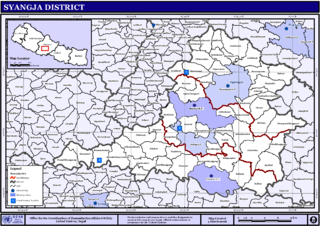
Pindikhola was a village development committee in Syangja District in the Gandaki Zone of central Nepal. At the time of the 2011 Nepal census it had a population of 4,956 people living in 1,119 individual households.
Kalagaudi is a Nepalese village. Kalagaudi is located in the Kanchanpur District of Sudurpashchim Pradesh of Nepal's Far-Western Development Region. As of the 2011 census, the village had a population of roughly 5,000.
Former administrative units of Nepal are administrative divisions during Kingdom of Nepal. In 2008 Nepal was proclaimed a federal republic and old administrative units restricted after adoption of new constitution on 20 September 2015.

Byas is a rural municipality located in Darchula District of Sudurpashchim Pradesh of Nepal.
