Related Research Articles
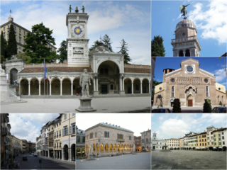
Udine is a city and comune (municipality) in northeastern Italy, in the middle of the Friuli-Venezia Giulia region, between the Adriatic Sea and the Carnic Alps. It is the capital of the Regional decentralization entity of Udine. Its population was 100,514 in 2012, 176,000 with the urban area.

The province of Pordenone was a province in the autonomous region of Friuli-Venezia Giulia, Italy, subdivided from the province of Udine in 1968. Its capital was the city of Pordenone. The province was abolished on 30 September 2017; it was reestablished in 2019 as the regional decentralization entity of Pordenone, and was reactivated on 1 July 2020. It has a total population of 312,794 inhabitants.

The flag of Friuli is the official standard of historical Friuli. A Friuli-Venezia Giulia Autonomous Regional law describes the flag as consisting of "…a rectangular standard featuring at its centre a golden heraldic eagle with outspread wings, headturned to the left, open beak and red claws, set in a sky blue field. The crest covers three fifths of the height of the flag, which in turn is two thirds of its length."

Angri is a town and comune in the province of Salerno, Campania, southern Italy. It is around 15 miles (24 km) northwest of the town of Salerno.
Montemagno is a comune (municipality) in the Province of Asti in the Italian region Piedmont, located about 50 kilometres (31 mi) east of Turin and about 13 kilometres (8 mi) northeast of Asti. As of 31 December 2010 it had a population of 1,228 and an area of 15.9 square kilometres (6.1 sq mi).

Torre di Santa Maria is a comune (municipality) in the Province of Sondrio in the Italian region Lombardy, located about 100 kilometres (62 mi) northeast of Milan and about 8 kilometres (5 mi) north of Sondrio. As of 31 December 2004, it had a population of 884 and an area of 45.5 square kilometres (17.6 sq mi).

Viadana is a comune (municipality) in the Province of Mantua in the Italian region Lombardy, located about 120 kilometres (75 mi) southeast of Milan and about 35 kilometres (22 mi) southwest of Mantua.

Bicinicco is a comune (municipality) in the Regional decentralization entity of Udine in the Italian region of Friuli-Venezia Giulia, located about 50 kilometres (31 mi) northwest of Trieste and about 15 kilometres (9 mi) south of Udine.
Castions di Strada is a comune (municipality) in the Regional decentralization entity of Udine in the Italian region of Friuli-Venezia Giulia, located about 60 kilometres (37 mi) northwest of Trieste and about 20 kilometres (12 mi) south of Udine.
Lestizza is a comune (municipality) in the Regional decentralization entity of Udine in the Italian region of Friuli-Venezia Giulia, located about 60 kilometres (37 mi) northwest of Trieste and about 15 kilometres (9 mi) southwest of Udine.

Mortegliano is a comune (municipality) in the Regional decentralization entity of Udine in the Italian region of Friuli-Venezia Giulia, located about 60 km northwest of Trieste and about 14 km southwest of Udine.

Pavia di Udine is a comune (municipality) in the Regional decentralization entity of Udine in the Italian region of Friuli-Venezia Giulia, located about 60 kilometres (37 mi) northwest of Trieste and about 9 kilometres (6 mi) southeast of Udine.

Pozzuolo del Friuli is a comune (municipality) in the Regional decentralization entity of Udine in the Italian region of Friuli-Venezia Giulia, located about 60 kilometres (37 mi) northwest of Trieste and about 10 kilometres (6 mi) southwest of Udine.
Santa Maria la Longa is a comune (municipality) in the Regional decentralization entity of Udine in the Italian region of Friuli-Venezia Giulia, located about 50 kilometres (31 mi) northwest of Trieste and about 15 kilometres (9 mi) southeast of Udine.
Spilamberto is a comune (municipality) in the Province of Modena in the Italian region Emilia-Romagna, located about 25 kilometres (16 mi) west of Bologna and about 10 kilometres (6 mi) southeast of Modena.
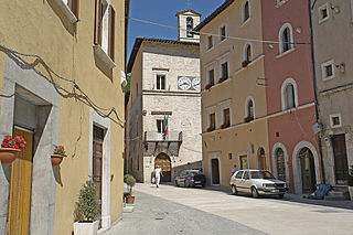
Visso is a comune (municipality) in the Province of Macerata in the Italian region Marche, located about 80 kilometres (50 mi) southwest of Ancona and about 50 kilometres (31 mi) southwest of Macerata. It houses the seat of Monti Sibillini National Park. It is one of I Borghi più belli d'Italia.

Montalto delle Marche is a comune (municipality) and former Latin catholic bishopric in the Province of Ascoli Piceno in the Italian region Le Marche, located in the hilly area that goes from the Adriatic cost to the Sibillini Mountains, at a distance of about 70 kilometres (43 mi) south of Ancona and about 15 kilometres (9 mi) north of Ascoli Piceno, with a population of 1 991 inhabitants. The municipal territory covers a 34 km2 area.

Castelnuovo Berardenga is a comune (municipality) in the province of Siena in the Italian region Tuscany, located about 50 kilometres (31 mi) southeast of Florence and about 14 kilometres (9 mi) east of Siena. Since 1932 it has been included in the Chianti wine-production area.

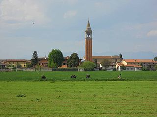
Sesto al Reghena is a comune (municipality) in the Regional decentralization entity of Pordenone, in the Italian region of Friuli-Venezia Giulia, located in the lower Friulian-Venetian plain about 80 kilometres (50 mi) northwest of Trieste and about 20 kilometres (12 mi) southeast of Pordenone.

The Gorizia Hills is a hilly microregion in western Slovenia and northeastern Italy. It lies on the right bank of the Soča (Isonzo) River, north of the Italian town of Gorizia, after which it is named. The region covers around 120 km2 (46 sq mi) and has about 7,000 inhabitants, mostly ethnic Slovenes, with a small number of Friulian speakers in its westernmost part.