Collier Range National Park is a national park in the Pilbara region of Western Australia, 878 km (546 mi) northeast of Perth.

Millstream Chichester National Park is a national park in the Pilbara region of Western Australia, located 1,190 kilometres (739 mi) north of the state capital, Perth.
The Pilbara is a large, dry, thinly populated region in the north of Western Australia. It is known for its Aboriginal peoples; its ancient landscapes; the red earth; and its vast mineral deposits, in particular iron ore. It is also a global biodiversity hotspot for subterranean fauna.

Tom Price is a mining town in the Pilbara region of Western Australia. It is located inland, at the edge of the Hamersley Range. Tom Price is the highest town above sea level in Western Australia, and is consequently dubbed "Top Town in WA".
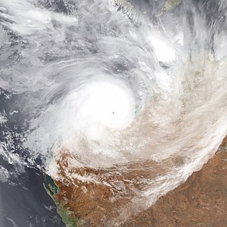
Severe Tropical Cyclone George was one of the most powerful Australian tropical cyclones on record, attaining a minimum barometric pressure of 902 mbar. It was also the strongest tropical cyclone worldwide in 2007 and the last Australian region tropical cyclone to achieve this record to date. The cyclone formed on 26 February 2007 in the Northern Territory's Top End, and intensified when it entered the Joseph Bonaparte Gulf, before crossing the northern coast of the Kimberley. It moved over the Indian Ocean, intensifying to a Category 4 cyclone, and eventually crossed the Pilbara coast just east of Port Hedland at peak intensity. After further analysis from the Bureau of Meteorology, George was reclassified to Category 5. The cyclone caused significant damage to the town of Port Hedland and numerous isolated mining camps around the town. Losses in Northern Territory amounted to at least A$12 million (US$9.5 million). Two people died and more than a dozen others were infected in a melioidosis outbreak following the Northern Territory floods. Insured damage in Western Australia amounted to A$8 million (US$6.2 million), and there were 3 fatalities.

Fortescue Metals Group is an Australian iron ore company. As of 2017, Fortescue is the fourth-largest iron ore producer in the world. The company has holdings of more than 87,000 km2 in the Pilbara region of Western Australia, making it the largest tenement holder in the state, larger than both BHP and Rio Tinto.

The Fortescue River is an ephemeral river in the Pilbara region of Western Australia. It is the third longest river in the state.
The Yule River is an ephemeral river in the Pilbara region of Western Australia. It was named on 10 August 1861 by the surveyor and explorer Frank Gregory while on expedition in the area, after Thomas Newte Yule, at times farmer of Toodyay, winemaker, Acting Colonial Secretary and Magistrate.
The Shaw River is an ephemeral river in the Pilbara region of Western Australia. It was named by explorer F.T. Gregory on 21 August 1861 after Norton Shaw, Secretary of the Royal Geographical Society.

The Mount Newman railway, owned and operated by BHP, is a private rail network in the Pilbara region of Western Australia built to carry iron ore. It is one of two railway lines BHP operates in the Pilbara, the other being the Goldsworthy railway.

The Cloudbreak mine is an iron ore mine located in the Pilbara region of Western Australia, 89 kilometres west-south-west of Nullagine, in the Chichester Range.
The Christmas Creek mine is an iron ore mine located in the Pilbara region of Western Australia, 61 kilometres south-south-west of Nullagine, in the Chichester Range.
Ngarluma and Kariyarra are members of a dialect continuum, which is a part of the Ngayarda language group of Western Australia, in the Pama–Nyungan language family. Some sources suggest that an extinct dialect, Jaburara, was a third member of the continuum. However, it is clear that Jaburara had a distinct identity that has been partly obscured by a collapse in the numbers of Jaburara speakers during the late 19th century, and there is some evidence that Jaburara may have instead been a dialect of Martuthunira.

Port Hedland is one of the largest iron ore loading ports in the world and the largest in Australia. In 2011 it had the largest bulk cargo throughput in Australia. With the neighboring ports of Port Walcott and Dampier, Port Hedland is one of three major iron ore exporting ports in the Pilbara region of Western Australia,
The George River is a river in the Pilbara region of Western Australia. The river was named on 16 July 1861 by the surveyor and explorer Frank Gregory, who was conducting an expedition in the area. It is not known after whom he named the river.
Coolawanyah Station, also spelt as Coolawaya Station, is a pastoral lease and sheep station located approximately 100 kilometres (62 mi) north of Tom Price, 150 kilometres (93 mi) south east of Karratha and 170 kilometres (106 mi) south west of Port Hedland, in the Shire of Ashburton, part of the Pilbara region of Western Australia. The property shares a boundary with Millstream Chichester National Park to the west.
Main Roads Western Australia controls the major roads in the state's Pilbara region. There are two main highways in the region: Great Northern Highway, which travels north through the region to Port Hedland and then north-west along the coast, as well as North West Coastal Highway, which heads south-west from Port Hedland. A series of main roads connects towns to the highways, and local roads provide additional links. The majority of these roads service the western half of the region, with few located in the various deserts east of the Oakover River. Roads are often named after the towns or areas they connect.
Millstream Station is a defunct pastoral lease that was once a sheep station and cattle station in Western Australia. The property is now part of Millstream Chichester National Park.

The Pilbara shrublands is a deserts and xeric shrublands ecoregion in Western Australia. It is coterminous with the Pilbara IBRA region. For other definitions and uses of "Pilbara region" see Pilbara.

Severe Tropical Cyclone Veronica was a large and powerful tropical cyclone which brought major impacts to the Pilbara region of Western Australia during March 2019. The nineteenth tropical low, eighth tropical cyclone and fifth severe tropical cyclone on the 2018–19 Australian region cyclone season, Veronica first appeared as a tropical low near East Timor on 18 March 2019. The system was slow to develop initially while tracking southwestwards through the Timor Sea, but began to consolidate the following day. The storm was upgraded by the Australian Bureau of Meteorology (BOM) to a Category 1 tropical cyclone on the Australian scale at 18:00 UTC on 19 March, by which time a steady development trend had begun. Upon attaining Category 2 status at 06:00 UTC on 20 March, Veronica underwent a period of explosive intensification. The system became a severe tropical cyclone six hours later, and Category 4 just six hours after that. Veronica reached peak intensity at 06:00 UTC the following day as a high-end Category 4 severe tropical cyclone, with ten-minute sustained winds estimated at 195 km/h (120 mph), and a central barometric pressure of 938 hPa. The United States' Joint Typhoon Warning Center estimated that the system was generating one-minute sustained winds of 230 km/h (145 mph), equivalent to a mid-range Category 4 major hurricane on the Saffir-Simpson hurricane wind scale. Veronica proceeded to weaken very gradually over the following few days as it turned towards Western Australia's Pilbara coastline. The system weakened to Category 3 while located just off the Pilbara coast, where it became almost stationary for 24 hours. Veronica began to weaken more quickly as it accelerated westwards on 25 March, tracking parallel to the coast. The system was downgraded below tropical cyclone intensity on 26 March, and after making landfall on North West Cape later that day, the system began to track away from the Australian mainland. Ex-Tropical Cyclone Veronica dissipated on 31 March over the eastern Indian Ocean.

