
Johnston County is a county located in the U.S. state of Oklahoma. As of the 2020 census, the population was 10,272. Its county seat is Tishomingo. It was established at statehood on November 16, 1907, and named for Douglas H. Johnston, a governor of the Chickasaw Nation.

Milburn is a town in Johnston County, Oklahoma, United States, along the Blue River. The population was 252 as of the 2020 Census. The town is notable as the location of the Chickasaw White House, the former home of Chickasaw Governor Douglas H. Johnston. This home is now a museum and is listed on the NRHP.
Tishomingo is the largest city in, and the county seat of, Johnston County, Oklahoma, United States. The population was 3,101 as of the 2020 Census,, an increase of 2.2% over the population of 3,034 reported at the 2010 census. It was the first capital of the Chickasaw Nation, from 1856 until Oklahoma statehood in 1907. The city is home to Murray State College, a community college with an annual enrollment of 3,015 students. Tishomingo is part of the Texoma region.

William Henry Davis "Alfalfa Bill" Murray was an American educator, lawyer, and politician who became active in Oklahoma before statehood as legal adviser to Governor Douglas H. Johnston of the Chickasaw Nation. Although not American Indian, he was appointed by Johnston as the Chickasaw delegate to the 1905 Convention for the proposed State of Sequoyah. Later he was elected as a delegate to the 1906 constitutional convention for the proposed state of Oklahoma; it was admitted in 1907.

Johnston Murray was an American lawyer, politician, and the 14th governor of Oklahoma from 1951 to 1955. He was a member of the Democratic Party. In 1956, Murray switched parties and joined the Republican Party.

The Choctaw Nation of Oklahoma is a Native American reservation occupying portions of southeastern Oklahoma in the United States. At roughly 6,952,960 acres, it is the second-largest reservation in area after the Navajo, exceeding that of eight U.S. states. The seat of government is located in Durant, Oklahoma.
Boggy Depot is a ghost town and Oklahoma State Park that was formerly a significant city in the Indian Territory. It grew as a vibrant and thriving town in present-day Atoka County, Oklahoma, United States, and became a major trading center on the Texas Road and the Butterfield Overland Mail route between Missouri and San Francisco. After the Civil War, when the MKT Railroad came through the area, it bypassed Boggy Depot and the town began a steady decline. It was soon replaced by Atoka as the chief city in the area. By the early 20th century, all that remained of the community was a sort of ghost town.

The Chickasaw Nation is a federally recognized Native American tribe with headquarters in Ada, Oklahoma, in the United States. They are an Indigenous people of the Southeastern Woodlands, originally from northern Mississippi, northwestern Alabama, southwestern Kentucky, and western Tennessee. Today, the Chickasaw Nation is the 13th largest tribe in the United States.
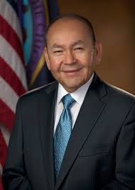
Billy Joe Anoatubby is the 32nd Governor of the Chickasaw Nation, a position he has held since 1987. From 1979 to 1987, Anoatubby served two terms as Lieutenant Governor of the Chickasaw Nation in the administration of Governor Overton James, after being popularly elected to office. He is a member of the Democratic Party.

Choctaw Country is the Oklahoma Department of Tourism and Recreation's official tourism designation for Southeastern Oklahoma. The name was previously Kiamichi Country until changed in honor of the Choctaw Nation headquartered there. The current definition of Choctaw Country includes ten counties, being Coal, Atoka, Bryan, Choctaw, McCurtain, Pushmataha, Le Flore, Latimer, Haskell, and Pittsburg counties. The department created the term as one of six designated travel regions within the state. However, other definitions of Southeastern Oklahoma may include additional counties.

The Curtis Act of 1898 was an amendment to the United States Dawes Act; it resulted in the break-up of tribal governments and communal lands in Indian Territory of the Five Civilized Tribes of Indian Territory: the Choctaw, Chickasaw, Muscogee (Creek), Cherokee, and Seminole. These tribes had been previously exempt from the 1887 General Allotment Act because of the terms of their treaties. In total, the tribes immediately lost control of about 90 million acres of their communal lands; they lost more in subsequent years.

South Central Oklahoma is an amorphous region in the state of Oklahoma, perhaps encompassing 10 counties. It is centered on the Arbuckle Mountains, an ancient, eroded range traversing some 70 miles (110 km) across the region, and surrounded by rivers and lakes, notably Lake Texoma, Lake Murray and Lake of the Arbuckles. For tourism purposes, the Oklahoma Department of Tourism has more narrowly defined South Central Oklahoma, which they refer to as Chickasaw Country, as being a seven-county region including Pontotoc, Johnston, Marshall, Garvin, Murray, Carter, and Love counties. A ten-county definition might also include Coal, Atoka, and Bryan counties, although the Department of Tourism includes those in Choctaw Country. The Choctaw Nation of Oklahoma covers the eastern third of the region. Its headquarters is in Durant, and its capitol building, now a museum, is in Tuskahoma. The Chickasaw Nation lies within the region, with the tribal capitol building located at Tishomingo and its headquarters in Ada. The Chickasaw Nation, which runs "Chickasawcountry.com"., promotes the idea of Chickasaw Country as the 13 south-central Oklahoma counties that comprise the Chickasaw Nation, being the Tourism Department’s seven counties plus Coal, Bryan, Jefferson, Stephens, Grady, and McClain counties.

Creek National Capitol, also known as Creek Council House, is a building in downtown Okmulgee, Oklahoma, in the United States. It was capitol of the Muscogee (Creek) Nation from 1878 until 1907. They had established their capital at Okmulgee in 1867, after the American Civil War.
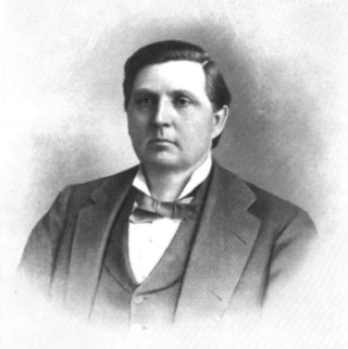
Douglas Hancock Cooper Johnston, also known as "Douglas Henry Johnston", was a tribal leader who served as the last elected governor of the Chickasaw Nation from 1898 to 1902. He was re-elected in 1904.

Bloomfield Academy was a Chickasaw school for girls founded in 1852 by the Reverend John Harpole Carr, located in the Chickasaw Nation in Indian Territory, about 3 miles (4.8 km) southeast of the present town of Achille, Oklahoma. A boarding school funded by both the Missouri Conference of the Methodist Church and the government of the Chickasaw Nation, it operated there until 1914, which a major fire destroyed most buildings. Now privately owned, the site of the former academy near Achille was listed on the National Register of Historic Places in 1972.
The Atoka Agreement is a document signed by representatives of the Choctaw and Chickasaw Indian Nations and members of the United States Dawes Commission on April 23, 1897, at Atoka, Indian Territory. It provided for the allotment of communal tribal lands of the Choctaw and Chickasaw nations in the Indian Territory to individual households of members of the tribes, who were certified as citizens of the tribes. Land in excess of the allotments could be sold to non-natives. Provisions of this agreement were later incorporated into the Curtis Act of 1898, which provided for widespread allotment of communal tribal lands.
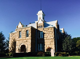
The historic Chickasaw Nation Capitols are located in Tishomingo, Oklahoma. The property consists of Chickasaw Council House Museum and the Chickasaw Nation Capitol building, which has been listed on the National Register of Historic Places since November 5, 1971.
Cyrus H. Harris, a mixed-blood Chickasaw born in Mississippi, was elected the first Governor of the Chickasaw Nation, and served five non-consecutive two-year terms. Although his formal schooling was limited at an elementary level, he became fluent in both the English and Chickasaw languages. He and his family relocated to Indian Territory in 1837, where he was employed in business and also served as an interpreter and developed a keen interest in Chickasaw politics. In 1856, he was elected to his first term as governor of the newly established Chickasaw Nation His accomplishments included organizing a national government after the Chickasaw Nation and Choctaw Nation formally separated into two distinct entities. He also executed a formal alliance between his nation and the Confederate States of America after the outbreak of the American Civil War. After the cessation of hostilities, he played a major role in the recovery of the nation from its devastated condition. He retired from politics in 1874, after serving his fifth term as governor. He died in 1887 at his home in Mill Valley, and was buried at the cemetery in Mill Valley.

Atoka County was a political subdivision of the Choctaw Nation of Indian Territory, prior to Oklahoma being admitted as a state. The county formed part of the Nation's Pushmataha District, or Third District, one of three administrative and judicial provinces called districts.

Pickens County was a political subdivision of the Chickasaw Nation in the Indian Territory from 1855, prior to Oklahoma being admitted as a state in 1907. The county was one of four that comprised the Chickasaw Nation. Following statehood, its territory was divided among several Oklahoma counties that have continued to the present.
