Related Research Articles

The Canadian Shield, also called the Laurentian Plateau, is a geologic shield, a large area of exposed Precambrian igneous and high-grade metamorphic rocks. It forms the North American Craton, the ancient geologic core of the North American continent. Glaciation has left the area with only a thin layer of soil, through which exposures of igneous bedrock resulting from its long volcanic history are frequently visible. As a deep, common, joined bedrock region in eastern and central Canada, the Shield stretches north from the Great Lakes to the Arctic Ocean, covering over half of Canada and most of Greenland; it also extends south into the northern reaches of the United States.

Diamond is a solid form of the element carbon with its atoms arranged in a crystal structure called diamond cubic. Another solid form of carbon known as graphite is the chemically stable form of carbon at room temperature and pressure, but diamond is metastable and converts to it at a negligible rate under those conditions. Diamond has the highest hardness and thermal conductivity of any natural material, properties that are used in major industrial applications such as cutting and polishing tools. They are also the reason that diamond anvil cells can subject materials to pressures found deep in the Earth.

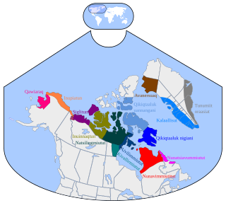
Baffin Island, in the Canadian territory of Nunavut, is the largest island in Canada and the fifth-largest island in the world. Its area is 507,451 km2 (195,928 sq mi) with a population density of 0.03/km²; the population was 13,039 according to the 2021 Canadian census; and it is located at 68°N70°W. It also contains the city of Iqaluit, which is the capital of Nunavut.

Kimberlite is an igneous rock and a rare variant of peridotite. It is most commonly known to be the main host matrix for diamonds. It is named after the town of Kimberley in South Africa, where the discovery of an 83.5-carat (16.70 g) diamond called the Star of South Africa in 1869 spawned a diamond rush and the digging of the open-pit mine called the Big Hole. Previously, the term kimberlite has been applied to olivine lamproites as Kimberlite II, however this has been in error.
Inuktitut, also known as Eastern Canadian Inuktitut, is one of the principal Inuit languages of Canada. It is spoken in all areas north of the North American tree line, including parts of the provinces of Newfoundland and Labrador, Quebec, to some extent in northeastern Manitoba as well as the Northwest Territories and Nunavut. It is one of the aboriginal languages written with Canadian Aboriginal syllabics.

Devon Island is an island in Canada and the largest uninhabited island in the world. It is located in Baffin Bay, Qikiqtaaluk Region, Nunavut, Canada. It is one of the largest members of the Arctic Archipelago, the second-largest of the Queen Elizabeth Islands, Canada's sixth-largest island, and the 27th-largest island in the world. It has an area of 55,247 km2 (21,331 sq mi). The bedrock is Precambrian gneiss and Paleozoic siltstones and shales. The highest point is the Devon Ice Cap at 1,920 m (6,300 ft) which is part of the Arctic Cordillera. Devon Island contains several small mountain ranges, such as the Treuter Mountains, Haddington Range and the Cunningham Mountains. The notable similarity of its surface to that of Mars has attracted interest from scientists.

Southampton Island is a large island at the entrance to Hudson Bay at Foxe Basin. One of the larger members of the Arctic Archipelago, Southampton Island is part of the Kivalliq Region in Nunavut, Canada. The area of the island is stated as 41,214 km2 (15,913 sq mi) by Statistics Canada. It is the 34th largest island in the world and Canada's ninth largest island. The only settlement on Southampton Island is Coral Harbour, called Salliq in Inuktitut.

The Ekati Diamond Mine ("Ekati") is Canada's first surface and underground diamond mine. It is located 310 km (190 mi) north-east of Yellowknife, Northwest Territories, and about 200 km (120 mi) south of the Arctic Circle, near Lac de Gras. Until 2014 Ekati was a joint venture between Dominion Diamond Mines (80%), and the two geologists who discovered kimberlite pipes north of Lac de Gras, Chuck Fipke and Stewart Blusson each holding a 10% stake in the mine, until Fipke sold his share to Dominion.

The Williamson Diamond Mine is a diamond mine 23 kilometres (14 mi) northeast of Shinyanga in Tanzania; it became well known as the first significant diamond mine outside of South Africa. The kimberlite pipe was found in March 1940 and the mine established by John Williamson, a Canadian geologist, and has been continuous operation since then, making it one of the oldest continuously operating diamond mines in the world. Over its lifetime it has produced over 19 million carats (3,800 kg) of diamonds. A 2020 report by The Guardian said that high-quality pink diamonds from the mine could value up to $700,000 a carat.

Auyuittuq National Park is a national park located on Baffin Island's Cumberland Peninsula, in the Qikiqtaaluk Region of Nunavut, the largest political subdivision of Canada. The park was initially known as Baffin Island National Park when it was established in 1972, but the name was changed in 1976 to its current name to better reflect the region and its history. It features many terrains of Arctic wilderness, such as fjords, glaciers, and ice fields. Although Auyuittuq was established in 1972 as a national park reserve, it was upgraded to a full national park in 2000.
The Hall Peninsula is a peninsula on the southern end of Baffin Island, in Nunavut, Canada. It lies between Frobisher Bay on the west, and the Cumberland Sound on the east between 62°40'N and 65°10'W. The Hall Peninsula is part of the Arctic Tundra biome—the world's coldest and driest biome. The Blunt Peninsula extends off the southeastern part of the Hall Peninsula.

The Brodeur Peninsula is an uninhabited headland on Baffin Island in the Qikiqtaaluk Region of Nunavut, Canada. It is located in the northwestern part of the island and is bounded by Prince Regent Inlet to the west, Lancaster Sound to the north, and Admiralty Inlet to the east. The peninsula is connected to the rest of Baffin Island by a narrow isthmus to the south.

The Churchill Craton is the northwest section of the Canadian Shield and stretches from southern Saskatchewan and Alberta to northern Nunavut. It has a very complex geological history punctuated by at least seven distinct regional tectonometamorphic intervals, including many discrete accretionary magmatic events. The Western Churchill province is the part of the Churchill Craton that is exposed north and west of the Hudson Bay. The Archean Western Churchill province contributes to the complicated and protracted tectonic history of the craton and marks a major change in the behaviour of the Churchill Craton with many remnants of Archean supracrustal and granitoid rocks.
Canadian diamonds are diamonds which have been mined in any one of the Provinces and territories of Canada. Diamond-rich areas weren't commercially extracted in Canada until the early 1990s. For the first 60 years of the 20th century, diamonds originated from kimberlite pipes and alluvial deposits in places such as Africa and some from South America. Later, diamond discoveries were made in the Soviet Union. Since the 1990s, major diamond discoveries were made and mining operations began. Canadian diamonds play a large role in the world market of diamonds.

Nunavut is the largest and northernmost territory of Canada. It was separated officially from the Northwest Territories on April 1, 1999, via the Nunavut Act and the Nunavut Land Claims Agreement Act, which provided this territory to the Inuit for independent government. The boundaries had been drawn in 1993. The creation of Nunavut resulted in the first major change to Canada's political map in half a century since the province of Newfoundland was admitted in 1949.
The Gahcho Kué Diamond Mine is located on the Canadian tundra in the Northwest Territories. It is situated at Kennady Lake, in the Akaitcho Treaty 8 Territory claim block, which is 85 km (53 mi) southeast of the Snap Lake Diamond Mine and approximately 280 km (170 mi) east northeast of Yellowknife. The site is served by Gahcho Kue Aerodrome, which has both an ice runway in winter and a year-round gravel runway, and a spur of the Tibbitt to Contwoyto Winter Road from Lupin Mine. the main camp is at 63°26′05″N109°12′02″W, north of the ice strip, with a smaller site at 63°25′48″N109°12′00″W, south of the runway.
The Attawapiskat kimberlite field is a field of kimberlite pipes located astride the Attawapiskat River in the Hudson Bay Lowlands, in Northern Ontario, Canada. It is thought to have formed about 180 million years ago in the Jurassic period when the North American Plate moved westward over a centre of upwelling magma called the New England hotspot, also referred to as the Great Meteor hotspot.

The Borden Peninsula is a peninsula on northern Baffin Island, in Nunavut, Canada. It lies some 80 km south of Devon Island, from which it is separated by Lancaster Sound. Northeastern Borden Peninsula is home to Sirmilik National Park.
The Victor Mine was the first Canadian diamond mine located in Ontario, and De Beers' second diamond mine in Canada. It is located in the Northern Ontario Ring of Fire, in the James Bay Lowlands 90 kilometres (56 mi) west of Attawapiskat in the remote northern part of the province. In June 2005, the Attawapiskat First Nation voted in favour (85.5%) of ratifying the Impact Benefit Agreement (IBA). Construction of the mine began in February 2006 which created 3200 positions; mining and operations will create around 400 permanent positions. The Victor Mine is an open-pit mine, with a processing plant, workshops, and an airstrip located on site. By 2013–2014 royalties collected from De Beers Victor Mine amounted to $226. At that time De Beers was continuing to pay off its "$1 billion investment to build the mine and from now until it closes, the company expects to pay tens of millions of dollars in royalties." The mine completed mining and processing in 2019 and has moved to a shut-down phase including demolition of infrastructure and rehabilitation of the site.
The geology of Nunavut began to form nearly three billion years ago in the Archean and the territory preserves some of the world's oldest rock units.
References
- 1 2 Pell, J., Grütter H., Neilson S., Lockhart, G., Dempsey, S. and Grenon, H. 2013. Exploration and discovery of the Chidliak Kimberlite Province, Baffin Island, Nunavut: Canada’s newest diamond district. Proceedings of 10th International Kimberlite Conference, Bangalore; Springer, New Delhi; extended abstract, 4 p.
- ↑ De Beers Group, 13 Sept. 2018. "De Beers Group completes acquisition of Peregrine Diamonds" . Retrieved 21 March 2020.
This article about a specific Canadian geological feature is a stub. You can help Wikipedia by expanding it. |