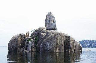
Mwanza City, also known as Rock City to the residents, is a port city and capital of Mwanza Region on the southern shore of Lake Victoria in north-western Tanzania. With an urban population of 1,311,000 in 2023, it is Tanzania's second largest city, after Dar es Salaam. It is also the second largest city in the Lake Victoria basin after Kampala, Uganda and ahead of Kisumu, Kenya at least in population size. Within the East African community, Mwanza city is the fifth largest city after Dar, Nairobi, Mombasa, and Kampala. It is slightly ahead of Kigali, Kisumu, and Bujumbura in the population of city proper limits. However, in terms of infrastructure, Kigali and Kisumu cities are way ahead of Mwanza. Mwanza city is also the capital city of Mwanza Region, and is administratively divided into two municipal districts within that Region - Ilemela and Nyamagana.

Ukerewe District is one of the seven districts of the Mwanza Region of Tanzania. It is located on Ukerewe Island, Ukara Island and other neighbouring islands within Lake Victoria. The largest settlement and the district's administrative capital is Nansio.

Mwanza Region is one of Tanzania's 31 administrative regions The region covers a land area of 25,233 km2 (9,743 sq mi). The region is comparable in size to the combined land area of the nation state of North Macedonia. Mwanza Region is bordered to the north through Lake Victoria by the Kagera Region and Mara Region, to the east by Simiyu Region, to the south by the Shinyanga Region and to the west by Geita Region. The regional capital is the city of Mwanza. According to the 2022 national census, the region had a population of 3,699,872 and national census of 2012 had 2,772,509. Mwanza Region is the second region with high population in Tanzania after Dar es Salaam Region

Sengerema District is one of seven districts in the Mwanza Region of Tanzania, East Africa. Its administrative headquarter is located in Sengerema city. It is bordered to the north and east by Lake Victoria, to the south by Geita Region and to the southeast by the Misungwi District. Sengerema district is known for having numerous lake islands in its territory the largest are Maisome Island and Kome Island.
As of 2021, there are 31 regions of Tanzania which are divided into 184 districts.
Olbalbal is an administrative ward in the Ngorongoro District of the Arusha Region of Tanzania. The ward is home to the famous Olduvai Gorge. The ward covers an area of 7.893 square kilometres (3.048 sq mi) with an average elevation of 1,405 metres (4,610 ft).
Katunguru, also Katungulu is an administrative ward in Sengerema District, Mwanza Region, Tanzania. In 2016 the Tanzania National Bureau of Statistics report there were 22,848 people in the ward, from 20,284 in 2012.

Kasingirima is an administrative ward in Kigoma-Ujiji District of Kigoma Region in Tanzania. The ward covers an area of 0.2 km2 (0.077 sq mi), and has an average elevation of 799 m (2,621 ft). In 2016 the Tanzania National Bureau of Statistics report there were 3,156 people in the ward, from 2,867 in 2012.
Kigoma is an administrative ward in Kigoma-Ujiji District of Kigoma Region in Tanzania. The ward covers an area of 4 km2 (1.5 sq mi), and has an average elevation of 789 m (2,589 ft). In 2016 the Tanzania National Bureau of Statistics report there were 7,604 people in the ward, from 6,908 in 2012.

Kitongoni is an administrative ward in Kigoma-Ujiji District of Kigoma Region in Tanzania. The ward covers an area of 1.2 km2 (0.46 sq mi), and has an average elevation of 773 m (2,536 ft). In 2016 the Tanzania National Bureau of Statistics report there were 7,675 people in the ward, from 6,973 in 2012.

Mwanga Kaskazini is an administrative ward in Kigoma-Ujiji District of Kigoma Region in Tanzania. The ward covers an area of 3.7 km2 (1.4 sq mi), and has an average elevation of 803 m (2,635 ft). In 2016 the Tanzania National Bureau of Statistics report there were 26,620 people in the ward, from 24,184 in 2012.

Rusimbi is an administrative ward in Kigoma-Ujiji District of Kigoma Region in Tanzania. The ward covers an area of 0.7 km2 (0.27 sq mi), and has an average elevation of 783 m (2,569 ft). In 2016 the Tanzania National Bureau of Statistics report there were 7,462 people in the ward, from 6,779 in 2012.
Kasimbu is an administrative ward in Kigoma-Ujiji District of Kigoma Region in Tanzania. The ward covers an area of 1.9 km2 (0.73 sq mi), and has an average elevation of 783 m (2,569 ft). In 2016 the Tanzania National Bureau of Statistics report there were 5,405 people in the ward, from 4,910 in 2012.
Katubuka is an administrative ward in Kigoma-Ujiji District of Kigoma Region in Tanzania. The ward covers an area of 3 km2 (1.2 sq mi), and has an average elevation of 814 m (2,671 ft). In 2016 the Tanzania National Bureau of Statistics report there were 27,287 people in the ward, from 24,790 in 2012.
Kipampa is an administrative ward in Kigoma-Ujiji District of Kigoma Region in Tanzania. The ward covers an area of 1.8 km2 (0.69 sq mi), and has an average elevation of 777 m (2,549 ft). In 2016 the Tanzania National Bureau of Statistics report there were 8,714 people in the ward, from 7,917 in 2012.
Machinjioni is an administrative ward in Kigoma-Ujiji District of Kigoma Region in Tanzania. The ward covers an area of 1.1 km2 (0.42 sq mi), and has an average elevation of 839 m (2,753 ft). In 2016 the Tanzania National Bureau of Statistics report there were 3,814 people in the ward, from 3,465 in 2012.
Majengo is an administrative ward in Kigoma-Ujiji District of Kigoma Region in Tanzania. The ward covers an area of 1.1 km2 (0.42 sq mi), and has an average elevation of 784 m (2,572 ft). In 2016 the Tanzania National Bureau of Statistics report there were 4,765 people in the ward, from 4,329 in 2012.
Rubuga is an administrative ward in Kigoma-Ujiji District of Kigoma Region in Tanzania. The ward covers an area of 1.2 km2 (0.46 sq mi), and has an average elevation of 784 m (2,572 ft). In 2016 the Tanzania National Bureau of Statistics report there were 2,899 people in the ward, from 2,634 in 2012.

Buchosa District, is a district in the Mwanza Region in the southern coastal Tanzania. The district is on the south shore of Lake Victoria west of the city of Mwanza and north of the Geita Region. Much of the district is large islands in the lake. The district was established in 2015.
Kahama is an administrative ward in Ilemela District, Mwanza Region, Tanzania. In the year 2016, the Tanzania National Bureau of Statistics reported that there were 8,197 people in the ward. Its post code is 33215.
