Ludewa District is one of six districts in the Njombe Region in Tanzania, East Africa. Prior to 2012, the district was one of the seven districts of Iringa Region. The town of Ludewa is the administrative seat of the district. A hospital is located in the city. The district is bordered to the north by the Njombe Rural District and Makete District, to the southeast by the Ruvuma Region and to the southwest by the country of Malawi across Lake Nyasa.

Ukerewe District is one of the seven districts of the Mwanza Region of Tanzania. It is located on Ukerewe Island, Ukara Island and other neighbouring islands within Lake Victoria. The largest settlement and the district's administrative capital is Nansio.

Mwanza Region is one of Tanzania's 31 administrative regions The region covers a land area of 25,233 km2 (9,743 sq mi). The region is comparable in size to the combined land area of the nation state of North Macedonia. Mwanza Region is bordered to the north through Lake Victoria by the Kagera Region and Mara Region, to the east by Simiyu Region, to the south by the Shinyanga Region and to the west by Geita Region. The regional capital is the city of Mwanza. According to the 2022 national census, the region had a population of 3,699,872 and national census of 2012 had 2,772,509. Mwanza Region is the second region with high population in Tanzania after Dar es Salaam Region

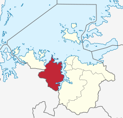
Ilemela District is one of the seven districts of the Mwanza Region of Tanzania with a postcode number 33200. It is bordered to the north and west by Lake Victoria, to the east by Magu District, and to the south by Nyamagana District. Part of the region's capital, the town of Mwanza, is within Ilemela District. The district commission's office is located in Buswelu area of Mwanza town.

Bagamoyo is one of the six districts of the Pwani Region of Tanzania. It is bordered to the north by the Tanga Region, to the west by the Morogoro Region, to the east by the Indian Ocean and to the south by the Kibaha District. The district capital is at Bagamoyo.
Kyela is one of the seven districts of Mbeya Region, Tanzania. It is bordered to the north by Rungwe District, to the northeast by Njombe Region, to the southeast by Lake Nyasa, to the south by Malawi and to the west by Ileje District.
As of 2021, there are 31 regions of Tanzania which are divided into 184 districts.

Uvinza is one of the eight administrative districts of Kigoma Region in Tanzania. Uvinza is bordered to the northwest by Kigoma District and Kigoma-Ujiji District. North of the district is bordered by Kasulu District. Lake Tanganyika borders the district on the west. Mpanda District in Katavi Region boders the district to the south and Kaliua District in Tabora Region borders the district to the east. The district is named in honor of the Vinza people whom the western part of district was their historic kingdom. Southern Uvinza District is home to the Mahale Mountains National Park. A unique park that is home to both Chimpanzees and lions in the same habitat.
Kirushya is one of 17 wards/divisions of Ngara District, in the Kagera Region of Tanzania. It is located near Burundi and Rwanda. The name itself comes from a word for "tedious"; the area is largely a dry hill, and the scarcity of water forced residents to travel long distances for resupply. Such a journey is tedious, hence the name. In the 2017 government plans, 41% of Kirushya's population had clean water.

Bukoba Rural District is one of the eight districts of the Kagera Region of Tanzania. It is bordered to the north by Missenyi District, to the east by Lake Victoria and Bukoba Urban District, to the south by Muleba District and to the west by Karagwe District. Its administrative seat is Bukoba town.
Katunguru, also Katungulu is an administrative ward in Sengerema District, Mwanza Region, Tanzania. In 2016 the Tanzania National Bureau of Statistics report there were 22,848 people in the ward, from 20,284 in 2012.
Kisesa is an administrative ward in the Magu District of the Mwanza Region of Tanzania. In 2016 the Tanzania National Bureau of Statistics report there were 9,889 people in the ward, from 30,486 in 2012.
Bugogwa is an administrative ward in Ilemela District, Mwanza Region, Tanzania with a postcode number 33207. In 2016 the Tanzania National Bureau of Statistics report there were 32,925 people in the ward, from 37,312 in 2012.
Kigoma District is one of the eight administrative districts of Kigoma Region in Tanzania. The district lies north of the city of Kigoma-Ujiji. Uvinza District, to the west and south of Ujiji, was split off from the Kigoma District in 1 July, 2013.

Busokelo is a new district in 2013 from Rungwe District within the Mbeya Region of Tanzania.

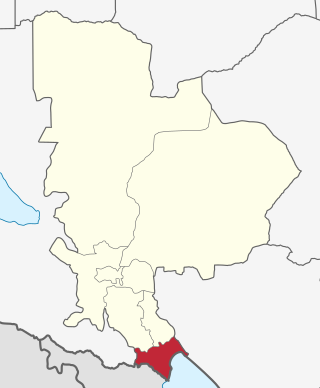
Mtwara Mikindani Municipal District Council is one of eight regional councils of the Mtwara Region in Tanzania. It is bordered to the north by the Lindi Region, to the east by the Indian Ocean and to the south and west by the Mtwara District. In 2016, the municipality has a total population of 113,732.
Simbo is an administrative ward in Kigoma Rural District of Kigoma Region in Tanzania. Prior to 2014 the ward was in the Uvinza District before moving to the Kigoma District.

Buchosa District, is a district in the Mwanza Region in the southern coastal Tanzania. The district is on the south shore of Lake Victoria west of the city of Mwanza and north of the Geita Region. Much of the district is large islands in the lake. The district was established in 2015.

Itigi District is a district council in the Singida Region of central Tanzania established in 2015. The district lies in the south-western portion of the Singida Region with 123,515 people and encompasses a large area mostly made up of protected game reserves.

Msalala District is a district council in the Shinyanga Region of Tanzania's lake zone established in 2012. The district lies in the middle of the region just north-east of the town of Kahama.