Ukerewe District

Last updated
Ukerewe
Halmashauri ya Wilaya ya Ukerewe (Swahili)
Ukerewe-2.jpg
Shores of Ukerewe Island.
Ukerewe District in Mwanza 2022.svg
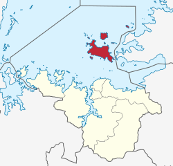
Ukerewe District of Mwanza Region
Coordinates: 2°03′S33°01′E / 2.050°S 33.017°E / -2.050; 33.017
Country Flag of Tanzania.svg Tanzania
Region Mwanza Region
District Ukerewe District
Boroughs
24 wards
  • Bukanda
  • Bukiko
  • Bukindo
  • Bukongo
  • Bukungu
  • Bwiro
  • Bwisya
  • Igala
  • Ilangala
  • Irugwa
  • Kagera
  • Kagunguli
  • Kakerege
  • Mukituntu
  • Muriti
  • Murutunguru
  • Nakatunguru
  • Namagondo
  • Namilembe
  • Nansio
  • Nduruma
  • Ngoma
  • Nkilizya
  • Nyamanga
Population
 (2016) [1] :148
  Total
388,778
Postcode
336xx
Area code 028
UFI -2574242
Website District Website

Ukerewe District [2] is one of the seven districts of the Mwanza Region of Tanzania. It is located on Ukerewe Island, Ukara Island and other neighbouring islands within Lake Victoria. The largest settlement and the district's administrative capital is Nansio.

Contents

In 2016 the Tanzania National Bureau of Statistics report there were 388,778 people in the district, from 345,147 in 2012. [1] :148 [3] :174

There are several small hotels and guest houses on the island to accommodate visitors.

The district is accessible by daily boat services between Mwanza city and Nansio. A road connecting the Island with Bunda district in Mara region via ferries on the eastern shore of Lake Victoria offers an alternative for those preferring not to travel by water.

Administrative subdivisions

Constituencies

For parliamentary elections, Tanzania is divided into constituencies. As of the 2020 elections Ukerewe District had one constituency: [4]

Divisions

Ukerewe District is administratively divided into divisions.

Wards

Ukerewe District is administratively divided into twenty-five wards: [5] [1] :148

References

  1. 1 2 3 2016 Makadirio ya Idadi ya Watu katika Majimbo ya Uchaguzi kwa Mwaka 2016, Tanzania Bara [Population Estimates in Administrative Areas for the Year 2016, Mainland Tanzania](PDF) (Report) (in Swahili). Dar es Salaam, Tanzania: National Bureau of Statistics. 2016-04-01. Archived (PDF) from the original on 2021-12-27. Retrieved 2022-07-03.
  2. Ukerewe District (Approved) at GEOnet Names Server, United States National Geospatial-Intelligence Agency
  3. 2012 Population and Housing Census - Population Distribution by Administrative Areas (PDF) (Report). Dar es Salaam, Tanzania: National Bureau of Statistics. 2013-03-01. Archived (PDF) from the original on 2022-03-26. Retrieved 2022-07-03.
  4. "Organisations located in Mwanza Region - Tanzania". African Development Information.
  5. "Mwanza Postcodes" (PDF). Tanzania Communications Regulatory Authority. Archived (PDF) from the original on 29 July 2022. Retrieved 9 August 2022.