Buchosa District

Last updated

Buchosa District
ISS028-E-6617 - View of Tanzania.jpg
Buchosa District and islands seen from the International Space Station.
Buchosa District in Mwanza 2022.svg
Buchosa District in Mwanza Region of Tanzania
Coordinates: 2°26′02″S32°18′50″E / 2.434°S 32.314°E / -2.434; 32.314
Country Flag of Tanzania.svg  Tanzania
Region Mwanza Region
District Buchosa District
Established [1] 2015
Government
  TypeCouncil
  Chairman [2] Julius Mulongo
  Director [2] Mheshimiwa Idama
Area
[3] :6
  Total4,480 km2 (1,730 sq mi)
  Land1,535 km2 (593 sq mi)
  Water2,945 km2 (1,137 sq mi)
Population
 (2016) [4] :145
  Total369,201
  Density82/km2 (210/sq mi)
Time zone EAT
Postcode [5]
33xxx
Area code 028
Website District Website

Buchosa District, is a district in the Mwanza Region in the southern coastal Tanzania. The district is on the south shore of Lake Victoria west of the city of Mwanza and north of the Geita Region. Much of the district is large islands in the lake. The district was established in 2015. [1]

Contents

Geography

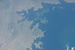
The district lies on islands and the southern shore of Lake Victoria. To the east is the Sengerema District that is also in the Mwanza Region. To the south and west is the Geita District of the Geita Region. Of the 4,480 square kilometres (1,730 sq mi) area of the district most, 2,945 km2 (1,137 sq mi), is water and only 1,535 km2 (593 sq mi) is land. [6] :7 [3] :6

Climate

The district's climate is tropical savanna with the Aw Koppen-Geiger system classification. There are two wet seasons, and one dry season. The primary wet season is October through December, and the secondary wet seasons is March and April. The dry seasons runs from late June to early September. The average rainfall is 1,414 millimetres (55.7 in) annually, and average temperature is 22.3 °C (72.1 °F). [7]

Administrative areas

The district consists of two divisions, 22 wards, 82 villages, and 410 hamlets. [3] :7 [8]

Wards (2016 Population) [4] :145

  • Bangwe (13,102)
  • Bugoro (5,124)
  • Buhama (14,051)
  • Bukokwa (20,072)
  • Bulyaheke (39,850)
  • Bupandwa (20,446)
  • Iligamba (13,565)
  • Irenza (13,274)
  • Kafunzo (12,101)
  • Kalebezo (21,357)
  • Kasisa (13,982)
  • Katwe (14,120)
  • Kazunzu (15,841)
  • Lugata (23,704)
  • Luhuza (7,744)
  • Maisome (18,573)
  • Nyakaliro (18,035)
  • Nyakasasa (2,920)
  • Nyakasungwa (9,466)
  • Nyanzenda (23,265)
  • Nyehunge (40,242)
  • Uharanyonga (8,367)

Demographics

In 2016 the Tanzania National Bureau of Statistics report there were 369,201 people in the district, from 327.767 in 2012. The district is made up of primarily people of the Zinza, Jita, Kerewe, Kara and Sukuma tribes. The average household size in 6.9 people. [4] :145 [9] [3] :11-12, 23

Economy

Buchosa District's economy is mostly farming and livestock keeping at 80% of the economy being agriculture. Of the 153,510 ha (379,300 acres) of land in the district, 132,019 ha (326,230 acres), which is 83%, is arable. Of that, 62,049 ha (153,330 acres), which is 47% of arable land, is currently cultivated. Buchosa is the largest producer of maize in the regions, and second largest producer of cassava. Other food crops include sweet potatoes, and is the only district in the region to grow rice. Cash crops are maize and cotton. [9] [3] :55

Buchosa District has a significant portion of the regions forest. The district has 14,964 ha (36,980 acres) of the regions 32,901 ha (81,300 acres) natural forest, and 33,000 ha (82,000 acres) of the regions 35,634 ha (88,050 acres) forest plantations. [3] :107

The district has no large, medium or small industry. There is fishing in the district with 1,280,503 tons in 2015. [3] :113,119

Roads

Buchosa District has no paved roads. For unpaved roads the district has 22.3 km (13.9 mi) of regional gravel roads, 79.4 km (49.3 mi) of district gravel or dirt roads, and 627.2 km (389.7 mi) of feeder dirt roads. The district has the most unpaved roads in the region of 728.9 km (452.9 mi) which in the wet season are unusable. [3] :124

Parks

Parts of the Rubondo Island National Park is in the district. The park consists of Rubondo Island, of the Geita Region, and other nearby islands along the southern shore of Lake Victoria. Wildlife on the islands are elephants, giraffes, chimpanzees, hippopotamus, crocodiles, sitatunga, bushbucks, suni, pythons, and pigs. There are also many water birds and fish eagles in the park. [10] [11]

Related Research Articles

<span class="mw-page-title-main">Regions of Tanzania</span> Subdivisions of Tanzania

Tanzania is administratively divided into thirty-one regions.

<span class="mw-page-title-main">Kagera Region</span> Region of Tanzania

Kagera Region is one of Tanzania's 31 administrative regions. The region covers an area of 35,686 km2 (13,778 sq mi). The region is comparable in size to the land area of the Netherlands. Kagera Region is bordered to the east by Lake Victoria, Mwanza Region and Mara Region. The region is bordered to the south by Geita Region and Kigoma Region. Lastly, Kagera borders Rwanda to the west, Uganda to the north and Burundi to the south west. The regional capital city is Bukoba. According to the 2022 national census, the region had 2,989,299, and 2012 the region had a population of 2,458,023.

<span class="mw-page-title-main">Ludewa District</span> District of Njombe Region, Tanzania

Ludewa District is one of six districts in the Njombe Region in Tanzania, East Africa. Prior to 2012, the district was one of the seven districts of Iringa Region. The town of Ludewa is the administrative seat of the district. A hospital is located in the city. The district is bordered to the north by the Njombe Rural District and Makete District, to the southeast by the Ruvuma Region and to the southwest by the country of Malawi across Lake Nyasa.

<span class="mw-page-title-main">Mwanza</span> City of Mwanza Region in Tanzania

Mwanza City, also known as Rock City to the residents, is a port city and capital of Mwanza Region on the southern shore of Lake Victoria in north-western Tanzania. With an urban population of 1,311,000 in 2023, it is Tanzania's second largest city, after Dar es Salaam. It is also the second largest city in the Lake Victoria basin after Kampala, Uganda and ahead of Kisumu, Kenya at least in population size. Within the East African community, Mwanza city is the fifth largest city after Dar, Nairobi, Mombasa, and Kampala. It is slightly ahead of Kigali, Kisumu, and Bujumbura in the population of city proper limits. However, in terms of infrastructure, Kigali and Kisumu cities are way ahead of Mwanza. Mwanza city is also the capital city of Mwanza Region, and is administratively divided into two municipal districts within that Region - Ilemela and Nyamagana.

<span class="mw-page-title-main">Kigoma Region</span> Region of Tanzania

Kigoma Region is one of Tanzania's 31 administrative regions. The regional capital is the city of Kigoma. Kigoma Region borders Kagera Region, Geita Region, Katavi Region, Tabora Region, DRC and Burundi According to the 2012 national census, the region had a population of 2,127,930, which was higher than the pre-census projection of 1,971,332. For 2002-2012, the region's 2.4 percent average annual population growth rate was tied for the fourteenth highest in the country. It was also the sixteenth most densely populated region with 57 people per square kilometer. With a size of 45,066 square kilometres (17,400 sq mi), the region is slightly smaller than Estonia.

<span class="mw-page-title-main">Mwanza Region</span> Region of Tanzania

Mwanza Region is one of Tanzania's 31 administrative regions The region covers a land area of 25,233 km2 (9,743 sq mi). The region is comparable in size to the combined land area of the nation state of North Macedonia. Mwanza Region is bordered to the north through Lake Victoria by the Kagera Region and Mara Region, to the east by Simiyu Region, to the south by the Shinyanga Region and to the west by Geita Region. The regional capital is the city of Mwanza. According to the 2022 national census, the region had a population of 3,699,872 and national census of 2012 had 2,772,509. Mwanza Region is the second region with high population in Tanzania after Dar es Salaam Region

<span class="mw-page-title-main">Sengerema District</span> District in Mwanza Region, Tanzania

Sengerema District is one of seven districts in the Mwanza Region of Tanzania, East Africa. Its administrative headquarter is located in Sengerema city. It is bordered to the north and east by Lake Victoria, to the south by Geita Region and to the southeast by the Misungwi District. Sengerema district is known for having numerous lake islands in its territory the largest are Maisome Island and Kome Island.

<span class="mw-page-title-main">Biharamulo District</span> District in Kagera Region, Tanzania

Biharamulo District is one of the eight districts of the Kagera Region of Tanzania. It is bordered to the north by Karagwe District and Muleba District, to the east and south by Geita Region, to the west by Ngara District, and to the southwest by the Kigoma Region. Its administrative seat is Biharamulo town. Biharamulo Game Reserve is located within the borders of the district.

As of 2021, there are 31 regions of Tanzania which are divided into 184 districts.

<span class="mw-page-title-main">Geita District</span> District in Geita, Tanzania

Geita District is located in the Geita Region of Tanzania. According to the 2012 census, the population of the district was 807,619. The district is bordered to the east by Mwanza Region and Nyang'hwale District, to the south by Shinyanga Region and Mbogwe District, and to the west by Chato District.

<span class="mw-page-title-main">Geita Region</span> Region of Tanzania

Geita Region is one of Tanzania's 31 administrative regions. The region covers an area of 20,054 km2 (7,743 sq mi)."Geita Region Size". The region is comparable in size to the combined land area of the nation state of Slovenia. Geita Region is bordered to the east by Lake Victoria, Mwanza Region and Shinyanga Region. The region is bordered by Tabora Region and Kigoma Region to the south and south west respectively. Lastly, Gieta is borders Kagera Region to the west.

<span class="mw-page-title-main">Chato District</span> District in Geita, Tanzania

Chato District is one of the five districts in Geita Region of northwestern Tanzania. Its administrative centre is the town of Chato. The main ethnic group in the district are the Sukuma. The late John Magufuli, who used to be as President of Tanzania from 2015—2021, was born in Chato.

<span class="mw-page-title-main">Bukoba Rural District</span> District in Kagera Region, Tanzania

Bukoba Rural District is one of the eight districts of the Kagera Region of Tanzania. It is bordered to the north by Missenyi District, to the east by Lake Victoria and Bukoba Urban District, to the south by Muleba District and to the west by Karagwe District. Its administrative seat is Bukoba town.

<span class="mw-page-title-main">Bukoba Urban District</span> District in Kagera Region, Tanzania

Bukoba Urban District is one of the eight districts of the Kagera Region of Tanzania. It is bordered to east by Lake Victoria and to the west by Bukoba Rural District. Its administrative seat is the town of Bukoba.

<span class="mw-page-title-main">Mtwara-Mikindani District, Mtwara</span> District of Mtwara Region, Tanzania

Mtwara Mikindani Municipal District Council is one of eight regional councils of the Mtwara Region in Tanzania. It is bordered to the north by the Lindi Region, to the east by the Indian Ocean and to the south and west by the Mtwara District. In 2016, the municipality has a total population of 113,732.

<span class="mw-page-title-main">Itigi District</span> District in Singida, Tanzania

Itigi District is a district council in the Singida Region of central Tanzania established in 2015. The district lies in the south-western portion of the Singida Region with 123,515 people and encompasses a large area mostly made up of protected game reserves.

<span class="mw-page-title-main">Msalala District</span> District in Shinyanga, Tanzania

Msalala District is a district council in the Shinyanga Region of Tanzania's lake zone established in 2012. The district lies in the middle of the region just north-east of the town of Kahama.

<span class="mw-page-title-main">Ushetu District</span> District in Shinyanga, Tanzania

Ushetu District is a district council in the Shinyanga Region of Tanzania's lake zone established in 2012. The district lies in west most portion of the region just south and west of the town of Kahama.

<span class="mw-page-title-main">Mpimbwe District</span> District in Katavi, Tanzania

Mpimbwe District is a district council in the Katavi Region of Tanzania's Southern Highlands established in 2012. The district lies in the south of the region on Lake Rukwa.

<span class="mw-page-title-main">Nsimbo District</span> District in Katavi, Tanzania

Nsimbo District is a district council in the Katavi Region of Tanzania's Southern Highlands established in 2012. The district lies in the middle of the region east of the city of Mpanda. It is a tropical environment of mostly forest reserves and agricultural economy.

References

  1. 1 2 "Historia". buchosadc.go.tz (in English and Swahili). Buchosa: Buchosa District. Archived from the original on 14 June 2022. Retrieved 4 September 2022.
  2. 1 2 "Halmashauri ya Wilaya ya Buchosa". buchosadc.go.tz (in Swahili). Buchosa: Buchosa District. Archived from the original on 19 June 2022. Retrieved 4 September 2022.
  3. 1 2 3 4 5 6 7 8 Mwanza Region Socio-Economic Profile (Report). National Bureau of Statistics (Tanzania). 1 December 2016. Archived from the original on 20 July 2022.
  4. 1 2 3 2016 Makadirio ya Idadi ya Watu katika Majimbo ya Uchaguzi kwa Mwaka 2016, Tanzania Bara [Population Estimates in Administrative Areas for the Year 2016, Mainland Tanzania](PDF) (Report) (in Swahili). Dar es Salaam, Tanzania: National Bureau of Statistics. 1 April 2016. Archived (PDF) from the original on 27 December 2021. Retrieved 3 July 2022.
  5. "Mwanza Postcodes" (PDF). Tanzania Communications Regulatory Authority. Archived (PDF) from the original on 29 July 2022. Retrieved 9 August 2022.
  6. "Mwanza Region Investment Guide" (PDF). United Nations Development Programme. Archived (PDF) from the original on 17 June 2022. Retrieved 4 September 2022.
  7. "Climate Nyehunge (Tanzania)". climate-data.org (in English and German). Germany: Climate-data. Archived from the original on 4 September 2022. Retrieved 4 September 2022.
  8. "Takwimu". buchosadc.go.tz (in Swahili). Buchosa: Buchosa District. Archived from the original on 14 June 2022. Retrieved 4 September 2022.
  9. 1 2 "Wasifu wa Halmashauri". buchosadc.go.tz (in Swahili). Buchosa: Buchosa District. Archived from the original on 6 July 2017. Retrieved 4 September 2022.
  10. "Rubondo Island National Park". tanzaniatourism.go.tz (in English and Swahili). Dodoma, Tanzania: Tanzania Tourist Board. Archived from the original on 19 August 2022. Retrieved 4 September 2022.
  11. "Rubondo Islands National Park". tanzaniaparks.go.tz (in English and Swahili). Dodoma, Tanzania: Tanzania National Parks Authority. Archived from the original on 6 July 2022. Retrieved 4 September 2022.