Chilavu

Last updated

Chilavu
Village
India Kerala location map.svg
Red pog.svg
Chilavu
Location in Kerala, India
India location map.svg
Red pog.svg
Chilavu
Chilavu (India)
Coordinates: 9°53′20″N76°47′07″E / 9.88889°N 76.78528°E / 9.88889; 76.78528 Coordinates: 9°53′20″N76°47′07″E / 9.88889°N 76.78528°E / 9.88889; 76.78528
Country India
State Kerala
District Idukki
Subdistrict Thodupuzha
Time zone UTC+05:30 (IST)
Pincode
685588 [1]

Chilavu is a small village in Thodupuzha Taluk. It lies in the Idukki district of Kerala, South India. The village is 12 km east of Thodupuzha, on the Velliyamattom route.

Thodupuzha Municipal town in Kerala, India

Thodupuzha is the largest town and municipality in Idukki district in the Kerala state of India, spread over an area of 35.43 km2. Thodupuzha is 57 km (35 mi) from Kottayam and 62 km (39 mi) south east of Kochi. Thodupuzha is 200 km from the state capital, Trivandrum. Geographical classification of Thodupuzha Region is Malanad or Idanad. Thodupuzha is also known as "Hollywood of Kerala" as it is used as a filming location for a large number of Malayalam and Tamil movies.

Idukki district District in Kerala, India

Idukki is one of the 14 districts of Kerala state, India, created on 26 January 1972. At that time, the district headquarters was at Kottayam. In June 1976 it was moved to Painavu. Idukki which lies in the Western Ghats of Kerala. Idukki is the second largest district in area but has the lowest population density. Idukki has a vast forest reserve area; more than a half of the district is covered by forests. The urban areas are densely populated whereas villages are sparsely populated. Idukki is also known as the spice garden of Kerala.

Kerala State in southern India

Kerala is a state on the southwestern, Malabar Coast of India. It was formed on 1 November 1956, following passage of the States Reorganisation Act, by combining Malayalam-speaking regions. Spread over 38,863 km2 (15,005 sq mi), Kerala is the twenty second largest Indian state by area. It is bordered by Karnataka to the north and northeast, Tamil Nadu to the east and south, and the Lakshadweep Sea and Arabian Sea to the west. With 33,387,677 inhabitants as per the 2011 Census, Kerala is the thirteenth-largest Indian state by population. It is divided into 14 districts with the capital being Thiruvananthapuram. Malayalam is the most widely spoken language and is also the official language of the state.

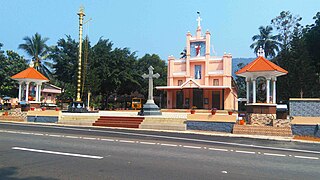
The main public establishments of Chilavu are Christ the King Catholic Church, Muhyudheen Juma Masjid, Sri Mahadevar Temple, St. Augustine's L.P School., BNE Madrasa and Masjidul Noor.

Chilavu is known as the 'Land of hills and natural beauty'. A post office, a branch of Alakodu Service Cooperative Bank, Chilavu Ayurvedic Dispensary, and Primary Health Centre are the main public institutions in Chilavu. It is a very small town having only a few hotels, stationary shops and provision shops. It is the Junction of three roads; to Karimannoor, Alakodu and Kalayanthani.

Karimannoor village in Kerala, India

Karimannoor is a panchayat, earlier it was a Legislative Constitutancy, belonging to Thodupuzha Thaluk in Idukki District, Kerala, India. The main occupation of the population is Agriculture, predominantly of natural rubber. Demographically people belonging to Christian, Hindu and Muslim religions live harmoniously in this beautiful piece of land in God's very Own Country. The predominant community here is the Syro-Malabar Catholic Christians.

Kalayanthani suburb in Kerala, India

Kalayanthani is a small suburb in Thodupuzha Taluk. It lies in the Idukki district of Kerala, South India. The suburb is 9 km east of Thodupuzha, on the Velliyamattom route.

Related Research Articles

Muvattupuzha Municipal Big Town in Kerala, India

Muvattupuzha is a prominent old town in the midlands directly to the east of Kochi. It is situated at around 40 km (25 mi) from downtown Kochi. The town is a growing urban centre in central Kerala and also an aspiring new district headquarter. The town is also popular as the starting point of Muvattupuzha river which happens by the merging of three rivers – namely Thodupuzhayar, Kaliyar and Kothayar – to form Muvattupuzhayaar. Thus, this Thriveni Sangamam or confluence of three rivers is called Muvattupuzha.

Udumbannoor is a panchayth in Idukki district and Thodupuzha taluk. It is situated in the western side of Idukki district. The main town in the panchayat is Udumbannoor. Udumbannoor is the first bio village in Kerala.

Syro-Malabar Catholic Eparchy of Kothamangalam eparchy

The Syro-Malabar Catholic Eparchy of Kothamangalam is an East Syriac Catholic eparchy in India, under the Syro-Malabar Catholic Church. It was established by Pope Pius XII in 1957. Mar Mathew Pothanamuzhy was the first bishop of the eparchy. Mar George Punnakottil served as the bishop until 10 January 2013, when his resignation was accepted by the synod. He was succeeded by Mar George Madathikandathil.

Kattappana Municipality in Kerala, India

Kattappana is a municipal town in the Sahyadri of Kerala state, India. It is the main urban centre in the high ranges of Idukki district, situated about 2,788.71–2,952.76 feet (850.00–900.00 m) above mean sea level, in the High Ranges, the high altitude region of Kerala has recently raised to the status of municipality. Kattappana is a CLASS III urban centre. It is the first municipality in high range of Idukki district with the real terraineous touch of Idukki as Thodupuzha municipality is situated in low range. It is a major commercial town and flourished with the boost in production of agriculture and spices. Based on the 2011 Census, it had a total population of 42646, consisting of 21,159 males and 21,487 females.

Main Eastern Highway road in Kerala, India

The Main Eastern Highway is the lifeline of the high range townships of the Travancore region of Kerala state, India. It is also known as Punalur-Pathanamthitta-Palai-Thodupuzha-Muvattupuzha Highway. Main Eastern Highway is categorized as State Highway - 08 of Kerala. It is the second longest State Highway of Kerala covering a distance of 153.6 km. The districts it passes through are Kollam, Pathanamthitta, Kottayam, Idukki and Ernakulam.

Thenathoor is a small village, population of 5000, located 16 kilometers from Thodupuzha, Kerala, India. Thodupuzha is the taluk headquarters of Thodupuzha taluk, one among the four taluks in Idukki District of Kerala.

Manathoor small town in Kerala, India

Manathoor is a small village in Kottayam district, aside Pala - Thodupuzha Highway, 12 km from Palai town and 15 km from Thodupuzha town.

Kalloorkkad village in Kerala, India

Kallorkkad is a village in Ernakulam district in Kerala, India. Most of its people are either farmers or engaged in small-scale business.

Thookkupalam village in Kerala, India

Thookupalam is a developing commercial centre lying about 10 kilometres (6.2 mi) from the Kerala-Tamil Nadu border in the Idukki district of Kerala, India. It lies on the banks of river Kallar and is one of the main tourist hubs between Thekkady, Munnar and Ramakkalmedu.

Chazhikattu Hospital Hospital in Kerala, India

Chazhikattu Hospital, Thodupuzha – is a multi-speciality hospital in Thodupuzha, Idukki district in Kerala, India. It was established in 1933 under the Chazhikattu Hospital Trust.

State Highway 33 is a State Highway in Kerala, India that starts in Thodupuzha and ends at Kumily road. The highway is 92.1 km long.

State Highway 43 is a State Highway in Kerala, India that starts in Muvattupuzha and ends in Theni Town. The highway is 105 km long. The Route Starts from Chali Bridge at Muvattupuzha Connecting to NH 49 towards Kothamangalam.

Arakulam Village in Kerala, India

Arakulam is a small village located in the Idukki district of Kerala state, India. Arakulam is 16 km from Thodupuzha which is the gateway to the high ranges of Kerala. Thodupuzha-Idukki road goes through this village. Arakulam is enriched with the Moovattupuzha River, the tail end of the Moolamattom Hydro Electric Power station, and where the Malankara Dam is located.

Muttom, Thodupuzha Gram Panchayat in Kerala, India

Muttom is a rural area in Idukki district in the Indian state of Kerala. This place is 66 km away from Cochin. Geographically this place is part of Midland or Idanad region of Kerala. Hindus, Christians and Muslims are living peacefully in the area.

Perumpillichira Grama Panchayat in Kerala, India

Perumpillichira is a small village that comes under the Panchayat of Kumaramangalam in Idukki district in the Indian state of Kerala. The name ‘Perumpillichira’ comes from the name of a large water reservoir adjacent to a Hindu temple at the heart of the village. This temple is the center point of the village. Water from Perumpillichira reservoir flows to nearby paddy field throughout the year except in peak summer and it finally reaches the Thodupuzha river. This place is 70 km away from the largest city Cochin in the state of Kerala.

Pizhaku Village in Kerala, India

Pizhaku is a village in Kottayam District in the Indian state of Kerala. It is located on the Pala–Thodupuzha state highway.

References

  1. "Pin Code: CHILAVU, IDUKKI, KERALA". PINcode.org.in. Retrieved 17 Feb 2015.