
Arequipa is a department in southwestern Peru. It is bordered by the departments of Ica, Ayacucho, Apurímac and Cusco in the north, the Department of Puno in the east, the Department of Moquegua in the south, and the Pacific Ocean in the west. Its capital, also called Arequipa, is Peru's second-largest city.

Arequipa is a province in the Arequipa Region, Peru. Its capital, Arequipa, is Peru's third most populous province of Peru. It borders the provinces of Islay, Camaná, Caylloma, and the Cusco and Puno regions. According to INEI in the year 2014 it has a population of 958.351 people.

Chilcayoc or Ch'illkayuq is the smallest of 11 districts of the Sucre Province in the Ayacucho region in Peru.
The Lucre District is one of the twelve districts in the Quispicanchi Province in Peru. Created by Law No. 9295 on January 17, 1941, its capital is the town of Lucre.

Pichu Pichu or Picchu Picchu is an inactive eroded volcano in the Andes of Peru. It is located in the Arequipa Region, Arequipa Province, on the border of Pocsi and Tarucani districts. Pichu Pichu reaches a height of 5,664 metres (18,583 ft) and is part of Salinas and Aguada Blanca National Reserve.
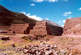
Mawk'allaqta, also Mawk'a Llaqta, the architectural Inca complex, is located above the contemporary village of San Antonio, 3,700 meters above sea level, and overlooks the neighbouring valley. The nearest bigger town, Pampacolca, is located approximately 170 kilometers north-west of the city Arequipa in the southern highlands of Peru.

Ticsho is a volcano in the Andes of Peru, about 3,860 metres (12,664 ft) high. It is situated in the "Valley of the Volcanoes" in the Arequipa Region, Castilla Province, Andagua District. Ticsho lies south-west of the volcano Puca Mauras and west of the volcano Yanamauras.
Puca Mauras is a volcano in the Andes of Peru, about 4,262 metres (13,983 ft) high. It is situated at the "Valley of the Volcanoes" in the Arequipa Region, Castilla Province, on the border of the districts of Andagua and Chilcaymarca. Puca Mauras lies in the western extensions of the Chila mountain range, northeast of the Ticsho and Yanamauras volcanoes.
Yanamauras is a volcano in the Andes of Peru, about 3,761 metres (12,339 ft) high. It is situated in the "Valley of the Volcanoes" in the Arequipa Region, Castilla Province, Andagua District. Yanamauras lies southwest of the Puca Mauras volcano and east of the Ticsho volcano.

Chilcayoc is a volcano in the Andes of Peru, about 3,347 metres (10,981 ft) high. It is situated in the "Valley of the Volcanoes" in the Arequipa Region, Castilla Province, Andagua District. Chilcayoc lies west of the Chachas Lake and north of the volcano Jechapita.
Jechapita is a volcano in the Andes of Peru, about 3,388 metres (11,115 ft) high. It is situated in the "Valley of the Volcanoes" in the Arequipa Region, Castilla Province, Andagua District. Jechapita lies west of the Chachas Lake and north-west of the volcano Chilcayoc Grande and south of the volcano Chilcayoc.
Mawk'allaqta or Mawk'a Llaqta may refer to:
Chillcamayu which upstream is called Jampamayo and downstream Pitumarca is a river in Peru located in the Cusco Region, Canchis Province, in the districts Checacupe and Pitumarca. Its waters flow to the Vilcanota River.

Hatun K'irawniyuq is a mountain in the Arequipa Region in the Andes of Peru, about 4,731.1 metres (15,522 ft) high. It is situated in the Condesuyos Province, Salamanca District, north of the volcano Coropuna. The peak west of K'irawniyuq is named Quri Qhawana (Ccorecahuana). One of the nearest populated places is Mawk'allaqta in the northeast. The village is situated at the mountain Mawk'a Llaqta (Mauca Llacta).

Choquepirhua is a mountain in the Chila mountain range in the Andes of Peru, about 5,400 metres (17,717 ft) high. It lies in the Arequipa Region, Castilla Province, on the border of the districts of Chachas and Choco. Choquepirhua is situated south of Chila.
P'isqi P'isqi is a mountain in the Andes of Peru, about 4,600 metres (15,092 ft) high. It lies in the Arequipa Region, Castilla Province, Andagua District. P'isqi P'isqi is situated west of Wakapallqa and Llallawi.
Ticlla is a 5,303-metre-high (17,398 ft) mountain in the Chila mountain range in the Andes of Peru. It is located in the Arequipa Region, Castilla Province, Chachas District. Ticlla lies southwest of Chila and Chila Pillune at a valley named Puncuhuaico. Its intermittent stream flows to Chachas Lake.
Sawsi is a 4,942-metre-high (16,214 ft) mountain in the Andes of Peru. It is situated in the Arequipa Region, Castilla Province, on the border of the districts of Chachas and Orcopampa. Sawsi lies at a lake named Machuqucha.
Jenchaña is a volcano in the Andes of Peru, about 3,600 m (11,800 ft) high. It is situated in the "Valley of the Volcanoes" in the Arequipa Region, Castilla Province, Andagua District. Jenchaña lies northwest of Chilcayoc.


