Childe's Tomb

Last updated

Childe's Tomb today Childe's tomb 2.jpg
Childe's Tomb today
Childe's Tomb before its destruction in 1812 Child's Tomb from Carrington's Dartmoor.jpg
Childe's Tomb before its destruction in 1812

Childe's Tomb is a granite cross on Dartmoor, Devon, England. Although not in its original form, it is more elaborate than most of the crosses on Dartmoor, being raised upon a constructed base, and it is known that a kistvaen is underneath.

Contents

A well-known legend attached to the site, first recorded in 1630 by Tristram Risdon, concerns a wealthy hunter, Childe, who became lost in a snow storm and supposedly died there despite disembowelling his horse and climbing into its body for protection. The legend relates that Childe left a note of some sort saying that whoever found and buried his body would inherit his lands at Plymstock. After a race between the monks of Tavistock Abbey and the men of Plymstock, the Abbey won.

The tomb was virtually destroyed in 1812 by a man who stole most of the stones to build a house nearby, but it was partly reconstructed in 1890.

Description

Childe's Tomb is a reconstructed granite cross on the south-east edge of Foxtor Mires, about 500 metres north of Fox Tor on Dartmoor, Devon, England at grid reference SX625704 . According to William Burt, in his notes to Dartmoor, a Descriptive Poem by N. T. Carrington (1826), the original tomb consisted of a pedestal of three steps, the lowest of which was built of four stones each six feet long and twelve inches square. The two upper steps were made of eight shorter but similarly shaped stones, and on top was an octagonal block about three feet high with a cross fixed upon it. [1]

The tomb lies on the line of several cairns that marked the east-west route of the ancient Monks' Path between Buckfast Abbey and Tavistock Abbey and it was no doubt erected here as part of that route: it would have been particularly useful in this part of the moor with few landmarks where a traveller straying from the path could easily end up in Foxtor Mires. [2] Tristram Risdon, writing in about 1630, said that Childe's Tomb was one of three remarkable things in the Forest of Dartmoor (the others being Crockern Tor and Wistman's Wood). [3] Risdon also stated that the original tomb bore an inscription: "They fyrste that fyndes and bringes mee to my grave, The priorie of Plimstoke they shall have", [4] but no sign of this has ever been found.

Today the cross, which is a replacement, is about 3 feet 4 inches (1.02 m) tall and 1 foot 8 inches (0.51 m) across at the crosspiece, and it has its base in a socket stone which rests on a pedestal of granite blocks that raises the total height of the cross to 7 ft (2.1 m). [5] The original, now broken, socket stone for the cross lies nearby. The whole is surrounded by a circle of granite stones set on their edge which once surrounded the cairn—the rocks of which are now scattered around—that was originally built over a large kistvaen that still exists beneath the pedestal. [2]

Destruction

All that remains of Fox Tor Farm Ruins of Foxtor Farm - geograph.org.uk - 635099.jpg
All that remains of Fox Tor Farm

In the early 19th century, there was much interest in enclosing and "improving" the open moorland on Dartmoor, encouraged by Sir Thomas Tyrwhitt's early successes at Tor Royal near Princetown. [6] Enclosure was aided by the greatly enhanced access provided by the construction of the first turnpike roads over the moor: the road between Ashburton and Two Bridges opened in around 1800, for instance. [7] In February 1809 one Thomas Windeatt, from Bridgetown, Totnes, took over the lease of a plot of land (a "newtake") of about 582 acres in the valley of the River Swincombe. In 1812 Windeatt started to build a farmhouse, Fox Tor Farm, on his land and his workmen robbed the nearby Childe's Tomb of most of its stones for the building and its doorsteps. [8] [9]

In 1902, William Crossing wrote that he had been told by an old moorman that some of the granite blocks from the tomb's pedestal had also been used to make a clapper bridge across a stream flowing into the River Swincombe near the farm. The moorman also said that they had lettering on their undersides. [10] This encouraged Crossing to arrange to lift the clapper bridge, but no inscription was found. However, he did locate nine out of the twelve stones that had made up the pedestal, as well as the broken socket stone for the cross. [8]

Reconstruction

Crossing rediscovered the original site of the tomb in 1882 and said that all that remained was a small mound and some half buried stones. He cleared out the kistvaen, reporting that it was 5 feet 6 inches (1.68 m) long by 2 feet 8 inches (81 cm) wide and that unlike most kistvaens found on the moor, the stones lining it had apparently been shaped by man, which led him to suggest that it was less old than most. [11] Having located most of the stones of the original tomb, Crossing thought that it could be rebuilt in its original form with little effort, but it was not to be. [12]

J. Brooking Rowe, writing in 1895, states that the tomb was re-erected in 1890 under the direction of Mr. E. Fearnley Tanner, who said that he was dissatisfied with the result because several stones were missing and it was difficult to recreate the original character of the monument. [13] Tanner was the honourable secretary of the Dartmoor Preservation Association, [14] and this reconstruction was one of the first acts of that organisation.[ citation needed ] The replacement base and cross were made in Holne in 1885. [14]

Childe the Hunter

View of the setting of Childe's Tomb Childe's tomb 1.jpg
View of the setting of Childe's Tomb

According to legend, the cross was erected over the kistvaen ('chest-stone' i.e. burial chamber) of Childe the Hunter, who was Ordulf, son of Ordgar, an Anglo-Saxon Earl of Devon in the 11th century. The name Childe is probably derived from the Old English word cild which was used as a title of honour. [15]

Legend has it that Childe was in a party hunting on the moor when they were caught in some changeable weather. [16] Childe became separated from the main party and was lost. In order to save himself from dying of exposure, he killed his horse, disembowelled it and crept inside the warm carcass for shelter. He nevertheless froze to death, but before he died, he wrote a note to the effect that whoever should find him and bury him in their church should inherit his Plymstock estate.

His body was found by the monks of Tavistock Abbey, who started to carry it back. However, they heard of a plot to ambush them by the people of Plymstock, at a bridge over the River Tavy. They took a detour and built a new bridge over the river, just outside Tavistock. They were successful in burying the body in the grounds of the Abbey and inherited the Plymstock estate.

The first account of this story is to be found in Risdon's Survey of Devon which was completed in around 1632:

It is left us by tradition that one Childe of Plimstoke, a man of fair possessions, having no issue, ordained, by his will, that wheresoever he should happen to be buried, to that church his lands should belong. It so fortuned, that he riding to hunt in the forest of Dartmore, being in pursuit of his game, casually lost his company, and his way likewise. The season then being so cold, and he so benumed therewith, as he was enforced to kill his horse, and embowelled him, to creep into his belly to get heat; which not able to preserve him, was there frozen to death; and so found, was carried by Tavistoke men to be buried in the church of that abbey; which was so secretly done but the inhabitants of Plymstoke had knowledge thereof; which to prevent, they resorted to defend the carriage of the corpse over the bridge, where, they conceived, necessity compelled them to pass. But they were deceived by guile; for the Tavistoke men forthwith built a slight bridge, and passed over at another place without resistance, buried the body, and enjoyed the lands; in memory whereof the bridge beareth the name of Guilebridge to this day. [4]

Finberg pointed out, however, that a document of 1651 refers to Tavistock's guildhall as Guilehall, so Guilebridge is more likely to be guild bridge, probably because it was built or maintained by one of the town guilds. [15]

Devon folk singer Seth Lakeman sang about Childe the Hunter on his 2006 album Freedom Fields .

Related Research Articles

<span class="mw-page-title-main">Dartmoor</span> National park in South West England

Dartmoor is an upland area in southern Devon, South West England. The moorland and surrounding land has been protected by National Park status since 1951. Dartmoor National Park covers 954 km2 (368 sq mi).

Princetown is a village located within Dartmoor national park in the English county of Devon. It is the principal settlement of the civil parish of Dartmoor Forest.

William Crossing (1847–1928) was a writer and chronicler of Dartmoor and the lives of its inhabitants. He lived successively at South Brent, Brentor and at Mary Tavy but died at Plymouth, Devon.

<span class="mw-page-title-main">Merrivale, Devon</span> Village in Devon, England

Merrivale is a locality in western Dartmoor, in the West Devon district of Devon, England. It is best known for the nearby series of Bronze Age megalithic monuments to the south and a former granite quarry.

<span class="mw-page-title-main">Dartmoor longhouse</span> Stone-built home, typical of Dartmoor, England

The Dartmoor longhouse is a type of traditional stone-built home, typically found on the high ground of Dartmoor, in Devon, England and belonging to a wider tradition of combining human residences with those of livestock under a single roof specific to western Britain; Wales, Cornwall and Devon, where they are more usually referred to simply as longhouses and in general housebarns.

<span class="mw-page-title-main">Fox Tor</span> Granite tor on Dartmoor in Devon, England

Fox Tor is a relatively minor tor on Dartmoor in the county of Devon, England.

<span class="mw-page-title-main">Bowerman's Nose</span> Stack of weathered granite on Dartmoor, Devon, England

Bowerman's Nose is a stack of weathered granite on Dartmoor, Devon, England. It is situated on the northern slopes of Hayne Down, about a mile from Hound Tor and close to the village of Manaton at grid reference SX742805. It is about 21.5 feet (6.6 m) high and is the hard granite core of a former tor, standing above a 'clitter' of the blocks that have eroded and fallen from it.

<span class="mw-page-title-main">Plymstock</span> Suburb of Plymouth, Devon

Plymstock is a commuter suburb of Plymouth and former civil parish in the English county of Devon.

<span class="mw-page-title-main">Crockern Tor</span> Tor on Dartmoor, England

Crockern Tor is a tor in Dartmoor National Park, Devon, England. Composed of two large outcrops of rock, it is 396 metres above sea level. The lower outcrop was the open-air meeting place of the Stannary Convocation of Devon from the early 14th century until the first half of the 18th century. On Parliament Rock, pictured here, the Lord Warden of the Great Court of the Devon Tinners supposedly sat during meetings of the Court.

<span class="mw-page-title-main">Tavistock Abbey</span> Ruined Benedictine abbey in Devon, England

Tavistock Abbey, also known as the Abbey of Saint Mary and Saint Rumon, is a ruined Benedictine abbey in Tavistock, Devon. Nothing remains of the abbey except the refectory, two gateways and a porch. The abbey church, dedicated to Our Lady and St Rumon, was destroyed by Danish raiders in 997 and rebuilt under Lyfing, the second abbot. The church was further rebuilt in 1285 and the greater part of the abbey between 1457 and 1458.

<span class="mw-page-title-main">Whiteworks</span> Former mining hamlet in Devon, England

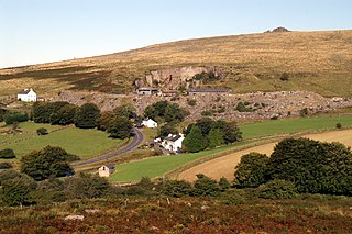
Whiteworks is a former mining hamlet near the town of Princetown, within Dartmoor National Park, in the English county of Devon. Tin mining is central to the history of settlement at Whiteworks, which was once home to one of Dartmoor's largest tin mines. The original cottages and their inhabitants were related to this industry, until the area became used increasingly for farming in the 20th century. The site has now largely been abandoned, although Whiteworks is still on the route of many walks including Abbots Way Walk passes 500 m to the west.

<span class="mw-page-title-main">Dartmoor crosses</span> Series of stone crosses found in Dartmoor National Park in Devon, England

The Dartmoor crosses are a series of stone crosses found in Dartmoor National Park in the centre of Devon, England. Many of them are old navigational aids, needed because of the remoteness of the moorland and its typically bad weather. Some mark medieval routes between abbeys. Other crosses were erected as memorials, for prayer, as town or market crosses, in churchyards, and as boundary markers. The crosses were erected over a long period of time, some as recently as 100 years ago, the earliest probably almost 1,000 years ago.

<span class="mw-page-title-main">Plymouth and Dartmoor Railway</span>

The Plymouth and Dartmoor Railway (P&DR) was a 4 ft 6 in gauge railway built to improve the economy of moorland areas around Princetown in Devon, England. Independent carriers operated horse-drawn wagons and paid the company a toll. It opened in 1823, and a number of short branches were built in the next few years.

<span class="mw-page-title-main">Sheepstor</span> Village in Devon, England

Sheepstor is a village, civil parish and former manor on the western side of Dartmoor in the county of Devon, England. In 2001, its population was 53, down from 95 in 1901. For administrative purposes the parish is grouped with the parishes of Meavy and Walkhampton to form Burrator Parish Council, and for electoral purposes it is grouped with the same two parishes to form Burrator Ward. Burrator Reservoir, constructed in 1898, is to the north of the village and forms part of the northern boundary of the parish.

<span class="mw-page-title-main">Dartmoor kistvaens</span> Cists from the late Neolithic and early Bronze Age

Dartmoor kistvaens are burial tombs or cists from the late Neolithic and early Bronze Age, i.e. from c. 2500 BC to c. 1500 BC. Kistvaens have been found in many places, including Dartmoor, a 954 km2 area of moorland in south Devon, England. The box-like stone tombs were created when the ancient people of the area lived in hut circles. Cists are often to be found in the centre of a cairn circle although some appear solitary which could be the result of the loss of an original slight mound. There are over 180 known cists on Dartmoor although there could be up to 100 that remain buried underneath unexplored cairns. In the South West there are no cists to be found on the Quantock Hills, only 2 to be found on Exmoor and 58 to be found on Bodmin Moor. The Dartmoor cists are unique in that about 94% have the longer axis of the tomb orientated in a NW/SE direction It appears that Dartmoor cists were positioned in such a way that the deceased were facing the Sun.

<span class="mw-page-title-main">Cosdon Hill</span> Hill on Dartmoor in Devon, England

Cosdon Hill, also called Cosdon Beacon, or Cawsand Beacon, is one of the highest hills on Dartmoor, in Devon, England. It has numerous traces of prehistoric occupation.

<span class="mw-page-title-main">Vixen Tor</span> Granite tor on Dartmoor in Devon, England

Vixen Tor is a tor on Dartmoor, England. The tor is on private land and since 2003 access by the public has been banned, causing protests and mass trespassing by hikers and climbers.

<span class="mw-page-title-main">Manor of Tor Mohun</span>

Tor Mohun is a historic manor and parish on the south coast of Devon, now superseded by the Victorian sea-side resort of Torquay and known as Tormohun, an area within that town. In 1876 the Local Board of Health obtained the sanction of Government to alter the name of the district from Tormoham (sic) to Torquay.

<span class="mw-page-title-main">Radford, Plymstock</span> Historic manor in Devon, England

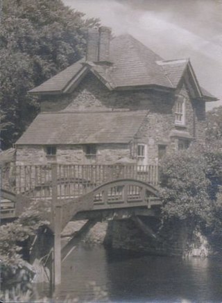
Radford in the parish of Plymstock in Devon is a historic manor and the oldest recorded seat of the prominent Harris family. It is today a low-cost housing suburb of the City of Plymouth. The 16th century manor house of the Harris family was remodelled in the 18th century and was demolished in 1937. However, various traces of the estate remain, including most notably the deerpark, now a public amenity known as Radford Park, with its large lake, an early 19th century gate-lodge at the entrance drive to the former mansion house, with gatepiers, on Radford Park Road, a bridge and boathouse with follies of a sham castle and another sham-ruin.

The manor of Alverdiscott was a manor situated in north Devon, England, which included the village of Alverdiscott.

References

  1. Reported by Crossing (1902) p. 89
  2. 1 2 Butler, Jeremy (1993). Dartmoor Atlas of Antiquities, Volume 4: The South-East. Exeter: Devon Books. pp. 218–220. ISBN   0861148819.
  3. Risdon (1811) pp. 222–223
  4. 1 2 Risdon (1811) pp. 198–199
  5. Sandles, Tim. "Childe's Tomb Cross". Legendary Dartmoor. Archived from the original on 25 November 2010. Retrieved 21 February 2019.
  6. Rowe (1985) p. 255
  7. Mercer, Ian (2009). Dartmoor – A Statement of its Time. London: Collins. p. 293. ISBN   978-0007184996.
  8. 1 2 Stanbrook (1994) p. 42–43
  9. Sandles, Tim. "Childe the Hunter". www.legendarydartmoor.co.uk. Archived from the original on 25 November 2010. Retrieved 7 February 2011.
  10. Crossing (1902) p. 93
  11. Crossing (1902) p. 91
  12. Crossing (1902) pp. 93–94
  13. Rowe (1985) pp. 188–9
  14. 1 2 Stanbrook (1994) p. 44
  15. 1 2 Finberg (1946) p. 277
  16. Urban, Sylvanus, Gent.; A.J.K. (January–June 1830). "June 1830 | Notices of Tavistock. | THE BRIDGES.". The Gentleman's Magazine and Historical Chronicle. Vol. C (Being the Twenty-Third of a New Series) Part the First. London: J.B. Nichols and Son. p. 491. In the reign of Edward III, one Child [sic] of Plimstock, a man of large possessions, hunting in the winter season on the trackless waste of Dartmoor, lost his way, and being pressed by the extremity of cold, killed his horse, embowelled him, and crept into his carcase [sic] for shelter ; but seeing little chance of preservation by this expedient, he at the same time made his will in the following terms, using some of the blood of his steed for ink :
    "He that finds and brings me to my tomb,
    "My lands which are at Plimstock shall be his doom."
    {{cite book}}: CS1 maint: multiple names: authors list (link)

Sources

50°31′02″N3°56′27″W / 50.51719°N 3.94085°W / 50.51719; -3.94085