
A geographic information system (GIS) consists of integrated computer hardware and software that store, manage, analyze, edit, output, and visualize geographic data. Much of this often happens within a spatial database, however, this is not essential to meet the definition of a GIS. In a broader sense, one may consider such a system also to include human users and support staff, procedures and workflows, the body of knowledge of relevant concepts and methods, and institutional organizations.

A gazetteer is a geographical dictionary or directory used in conjunction with a map or atlas. It typically contains information concerning the geographical makeup, social statistics and physical features of a country, region, or continent. Content of a gazetteer can include a subject's location, dimensions of peaks and waterways, population, gross domestic product and literacy rate. This information is generally divided into topics with entries listed in alphabetical order.
A GIS file format is a standard for encoding geographical information into a computer file, as a specialized type of file format for use in geographic information systems (GIS) and other geospatial applications. Since the 1970s, dozens of formats have been created based on various data models for various purposes. They have been created by government mapping agencies, GIS software vendors, standards bodies such as the Open Geospatial Consortium, informal user communities, and even individual developers.
A GIS software program is a computer program to support the use of a geographic information system, providing the ability to create, store, manage, query, analyze, and visualize geographic data, that is, data representing phenomena for which location is important. The GIS software industry encompasses a broad range of commercial and open-source products that provide some or all of these capabilities within various information technology architectures.

A virtual globe is a three-dimensional (3D) software model or representation of Earth or another world. A virtual globe provides the user with the ability to freely move around in the virtual environment by changing the viewing angle and position. Compared to a conventional globe, virtual globes have the additional capability of representing many different views of the surface of Earth. These views may be of geographical features, man-made features such as roads and buildings, or abstract representations of demographic quantities such as population.
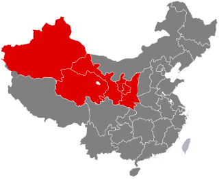
Northwestern China (西北) is a geographical region of China which includes three provinces and two autonomous regions.

gvSIG, geographic information system (GIS), is a desktop application designed for capturing, storing, handling, analyzing and deploying any kind of referenced geographic information in order to solve complex management and planning problems. gvSIG is known for having a user-friendly interface, being able to access the most common formats, both vector and raster ones. It features a wide range of tools for working with geographic-like information.
The Lemur Project is a collaboration between the Center for Intelligent Information Retrieval at the University of Massachusetts Amherst and the Language Technologies Institute at Carnegie Mellon University. The Lemur Project develops search engines, browser toolbars, text analysis tools, and data resources that support research and development of information retrieval and text mining software. The project is best known for its Indri and Galago search engines, the ClueWeb09 and ClueWeb12 datasets, and the RankLib learning-to-rank library. The software and datasets are used widely in scientific and research applications, as well as in some commercial applications.
A historical geographic information system is a geographic information system that may display, store and analyze data of past geographies and track changes in time. It can be regarded as a tool for historical geography.
The China Historical Geographic Information System (CHGIS) is a Historical GIS project for creating a database of populated places and historical administrative units for the period of Chinese history between 222 BCE and 1911 CE. The project creates a dataset which tracks changes in place names, administrative status, and geography. It is a joint project of Harvard University and Fudan University. Its director is Professor Peter K. Bol of Harvard.
A Spatial Data Infrastructure (SDI), also called geospatial data infrastructure, is a data infrastructure implementing a framework of geographic data, metadata, users and tools that are interactively connected in order to use spatial data in an efficient and flexible way. Another definition is "the technology, policies, standards, human resources, and related activities necessary to acquire, process, distribute, use, maintain, and preserve spatial data".
David Der-wei Wang is a literary historian, critic, and the Edward C. Henderson Professor of Chinese Literature at Harvard University. He has written extensively on post-late Qing Chinese fiction, comparative literary theory, colonial and modern Taiwanese literature, diasporic literature, Chinese Malay literature, Sinophone literature, and Chinese intellectuals and artists in the 20th century. His notions such as "repressed modernities", "post-loyalism", and "modern lyrical tradition" are instrumental and widely discussed in the field of Chinese literary studies.

Michael A. Szonyi is Professor of Chinese History at Harvard University and former director of the Fairbank Center for Chinese Studies. His research focuses on the local history of southeast China, especially in the Ming dynasty, the history of Chinese popular religion, and Overseas Chinese history.

Geospatial topology is the study and application of qualitative spatial relationships between geographic features, or between representations of such features in geographic information, such as in geographic information systems (GIS). For example, the fact that two regions overlap or that one contains the other are examples of topological relationships. It is thus the application of the mathematics of topology to GIS, and is distinct from, but complementary to the many aspects of geographic information that are based on quantitative spatial measurements through coordinate geometry. Topology appears in many aspects of geographic information science and GIS practice, including the discovery of inherent relationships through spatial query, vector overlay and map algebra; the enforcement of expected relationships as validation rules stored in geospatial data; and the use of stored topological relationships in applications such as network analysis. Spatial topology is the generalization of geospatial topology for non-geographic domains, e.g., CAD software.
A prosopographical network is a system which represents a historical group made up by individual actors and their interactions within a delimited spatial and temporal range. The network science methodology offers an alternative way of analyzing the patterns of relationships, composition and activities of people studied in their own historical context. Since prosopography examines the whole of a past society, its individuals who made it up, and its structure, this independent science of social history uses a collective study of biographies of a well-defined group, in a multiple career analysis, for collecting and interpreting relevant quantities of data, these same set of data can be employed for constructing a network of the studied group. Prosopographical network studies have emerged as a young and dynamic field in historical research; nevertheless, the category of prosopographical network is in its formative, initial phase and as a consequence it is hard to view as a stable and defined notion in history and beyond social network analysis. See also narrative network.

Apache Drill is an open-source software framework that supports data-intensive distributed applications for interactive analysis of large-scale datasets. Built chiefly by contributions from developers from MapR, Drill is inspired by Google's Dremel system. Drill is an Apache top-level project. Tom Shiran is the founder of the Apache Drill Project. It was designated an Apache Software Foundation top-level project in December 2016.
The GDELT Project, or Global Database of Events, Language, and Tone, created by Kalev Leetaru of Yahoo! and Georgetown University, along with Philip Schrodt and others, describes itself as "an initiative to construct a catalog of human societal-scale behavior and beliefs across all countries of the world, connecting every person, organization, location, count, theme, news source, and event across the planet into a single massive network that captures what's happening around the world, what its context is and who's involved, and how the world is feeling about it, every single day." Early explorations leading up to the creation of GDELT were described by co-creator Philip Schrodt in a conference paper in January 2011. The dataset is available on Google Cloud Platform.
Open energy system database projects employ open data methods to collect, clean, and republish energy-related datasets for open use. The resulting information is then available, given a suitable open license, for statistical analysis and for building numerical energy system models, including open energy system models. Permissive licenses like Creative Commons CC0 and CC BY are preferred, but some projects will house data made public under market transparency regulations and carrying unqualified copyright.
Peter Kees Bol is an American historian and sinologist. He is the Charles H. Carswell Professor of East Asian Languages and Civilizations of Harvard University. Since 2013, he has been a Vice Provost of Harvard with oversight of HarvardX and the Harvard Initiative in Learning and Teaching (HILT). He is the founding director of the Harvard Center for Geographic Analysis, and also directs the China Historical Geographic Information System (CHGIS) and the China Biographical Database (CBDB) project.

